

Landmark Ensenada, Baja California Tijuana to Ensenada coast
A sea blowhole on the Punta Banda peninsula that shoots spray up to about 30 m, reached by a street of souvenir and food stalls.
From Ensenada: 45 min by car (38 km by road) How to get there ↓
Plan your visit to La Bufadora
Where to stay near La Bufadora
Compare hotels, posadas and guest houses in La Bufadora.
Tours to La Bufadora
Look for tours of the area around Tecate that stop at La Bufadora.
 La Bufadora Tour in Baja California
★ 4.8 (221) · From US$47
How to get to La Bufadora
- From Ensenada: about 45 min by road (~38 km)
- Nearest airport: Tijuana (TIJ), 40 min by car to Tecate
Links open a partner site. We may earn a commission if you book, at no cost to you.
Popular tours to La Bufadora


Tours, prices and ratings from Viator, checked weekly. We may earn a commission if you book.
About La Bufadora
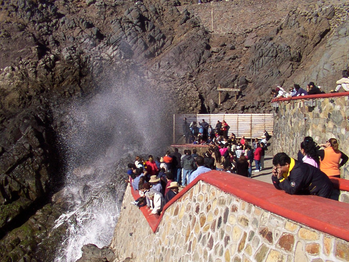
La Bufadora is a marine blowhole on the Punta Banda peninsula, in the municipality of Ensenada, Baja California, on the Pacific side south of Bahía de Todos Santos. It lies roughly 30 km south of the city of Ensenada, at the end of a winding road that leaves Highway 1 and crosses the peninsula to the coast. It is one of the most visited natural stops in the state, and it is easy to spot when you arrive: a plume of spray rising from the cliff above a cluster of rocks.
The effect comes from a sea cave rather than a spring. Swells push water and air into the cave, the air is compressed, and when the water recedes the trapped air blasts out through a narrow opening, sending the seawater into the air in a column that Wikipedia says can reach about 30 meters above sea level. The timing follows the swell, so there is a pause between spouts, usually a minute or two, and bigger bursts come with higher tide and a larger swell. A local legend says a whale trapped at the point blew water to call its pod and was turned to stone.
The approach is part of the experience. From the parking lot, a street of stalls roughly 150 meters long leads down to the viewing platform, lined with shops selling pottery, blankets, jewelry and trinkets, and food stands with churros, fish tacos and seafood cocktails; in 2017 some 150 businesses were reported operating there. Vendors will call out to you, and bargaining is normal. The stone platforms above the blowhole have rails, and part of the path is passable for strollers, though steep in places. On sunny days you can look for sea birds and sea lions on the rocks off the point, and in winter whales pass offshore.
Go near high tide for the strongest spray, and on a weekday morning if you want fewer people; weekends and holidays are crowded. Plan for a visit of an hour or less, and bring cash for parking, the restrooms and the stalls. It is often paired with a day in Ensenada and the Valle de Guadalupe, or with a stop at the Punta Banda beaches.
How to get to La Bufadora
Drive from Ensenada: 45 min, 38 km
La Bufadora is roughly 30 km south of Ensenada (sources give 27 to 38 km): take the Transpeninsular south and follow the signs to La Bufadora across the Punta Banda peninsula, a drive of roughly 40 minutes. The last stretch is curvy. Park in one of the lots at the end of the road, where parking costs a small fee; one guidebook lists 50 pesos, undated. Tours from Ensenada also go.
Directions to La Bufadora on Google Maps
Distances are in a straight line; the road is usually longer.
Links open a partner site. We may earn a commission if you book, at no cost to you.
From the nearest cities to La Bufadora
- Ensenada · 38 km by road, 45 min
- Tijuana · 142 km by road, 2 h 10 min
- Tecate · 147 km by road, 2 h 25 min
Drive times by road from OpenStreetMap, without traffic or stops. Times marked ~ are estimated from the straight-line distance.
Before you go to La Bufadora: hours, prices and tips
- Entry
- Viewing the blowhole is free; parking is a small fee, listed at 50 pesos in one undated guide. Lonely Planet · checked Oct 2026
- Best time of day
- High tide gives the strongest eruptions, and weekday mornings are quieter; weekends and national holidays are the busiest. Airial Travel · checked Oct 2026
Hours and prices change, especially around holidays. Each fact links to where we checked it.
Visiting La Bufadora: what to see and do
Watch the blowhole spout from the stone viewing platforms.
Walk down the street of stalls selling crafts, pottery and blankets.
Eat churros, fish tacos or a seafood cocktail at the food stands.
Look for sea lions and sea birds on the rocks off the point.
Come near high tide for the biggest spray.
Spot whales offshore in winter.
Plan your trip
Places to stay in La Bufadora
Compare hotels, posadas, and rentals in and around La Bufadora.
Tours & activities
Look for tours of the area around Tecate that stop at La Bufadora.
Rental cars
Pick up a car at TIJ (Tijuana): about 40 min by road to Tecate, then 94 km more to La Bufadora, on your own schedule.
Flights
The nearest airport with scheduled flights is Tijuana (TIJ), about 40 min by road from Tecate, the base for La Bufadora.
Mobile data
Signal can drop away from Tecate: download a map of the way to La Bufadora before you set out, or carry an eSIM with data.
Links open a partner site. We may earn a commission if you book, at no cost to you.
Photos
When to go to La Bufadora mild
La Bufadora shares the climate of Tecate, 94 km away. The best months to visit are May, June, September, and October.
See the month-by-month climate of Tecate
Weather in La Bufadora now and the next 7 days
Live forecast from Open-Meteo. Chance of rain is the day's highest.
The closest Pueblo Mágico: Tecate

Tecate is the Pueblo Mágico closest to La Bufadora, with places to stay, food, and more to see.
Closest to La Bufadora
-
Ensenada · City · 19 km away
-
Valle de Guadalupe · Nature reserve · 42 km away


Near La Bufadora

Drive times by road from OpenStreetMap, without traffic. Times marked ~ are estimated from the straight-line distance.
Location from OpenStreetMap. Written by Puebloteca.