Archaeological site Calakmul, Campeche Río Bec Route
Capital of the Snake Head kingdom, Tikal's great rival, with over 6,000 structures and a 55-metre pyramid deep in the Calakmul forest.
From Palenque: about 4 h 35 min by road (~310 km) How to get there ↓
Plan your visit to Calakmul
Where to stay near Calakmul
Compare hotels, posadas and guest houses in Calakmul.
Tours to Calakmul
A guide brings Calakmul to life: look for tours from Campeche that include the site and the ride there.
How to get to Calakmul
- From Palenque: about 4 h 35 min by road (~310 km)
Links open a partner site. We may earn a commission if you book, at no cost to you.
About Calakmul
Calakmul is a Maya city in the far south of Campeche, in the core of the Calakmul Biosphere Reserve and some 35 km from the Guatemalan border. It is one of the largest Maya sites known: the ruins spread over about 70 square kilometres with more than 6,000 recorded structures, and at its height the city ruled a territory of over 13,000 square kilometres. Its modern name, given by the botanist Cyrus Lundell, means "two adjacent mounds"; the inscriptions call the centre Uxte' Tuun, "three stones", and Chiik Naab.
Between roughly 250 BC and AD 700 it was the leading city of the Maya lowlands and the seat of the Kaan, or Snake Head, dynasty. Its rivalry with Tikal shaped the region's politics for more than a century: Calakmul and its allies defeated Tikal in 562, and Tikal struck back and beat Calakmul in 695. Glyph readings give the names of 18 kings, among them Yuknoom the Great (636–686) and Yich'aak K'ahk', "Jaguar Paw". The city slowly declined after that defeat; the last dated stela is from 909. Lundell reported the ruins in 1931, Sylvanus Morley came to study the stelae the next year, and real excavations only began in 1982 with the Universidad Autónoma de Campeche, followed by INAH. They turned up royal tombs and the jade funerary masks now shown in Campeche city.
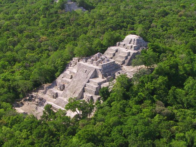
The visit centres on the Great Plaza and the buildings around it. Structure II, on the south side, is a massive Petén-style pyramid about 55 metres high, built over earlier phases going back to the Preclassic, and from its top the forest runs flat to every horizon, with the second great pyramid, Structure I, rising out of it. Calakmul has more stelae than any other Maya city, around 120, many still standing in front of the temples. Because it sits inside the reserve, howler and spider monkeys, toucans and ocellated turkeys are part of the visit. UNESCO listed the site in 2002 and extended it in 2014 to a mixed natural and cultural World Heritage Site together with the forest around it.
How to get to Calakmul
Take Federal Highway 186 (Escárcega–Chetumal) to the signed turnoff at km 95, about 60 km west of Xpujil, where the reserve gate is. From there a narrow paved road runs about 60 km through the forest to the site, so count on roughly two hours each way from Xpujil. There is no public transport inside the reserve: drive, hire a taxi for the day or join a day tour from Xpujil, the nearest town with hotels and the Tren Maya station.
Directions to Calakmul on Google Maps
Distances are in a straight line; the road is usually longer.
Links open a partner site. We may earn a commission if you book, at no cost to you.
From the nearest cities to Calakmul
- Palenque · about 310 km by road, ~4 h 35 min
- Chetumal · 235 km by road, 4 h 45 min
- Campeche · 305 km by road, 5 h 45 min
Drive times by road from OpenStreetMap, without traffic or stops. Times marked ~ are estimated from the straight-line distance.
Before you go to Calakmul: hours, prices and tips
- Hours
- Daily 8:00 am–5:00 pm; last entry 4:00 pm. INAH · checked Oct 2026
- Entry
- Two fees: INAH site entry 210 pesos for foreigners (105 for Mexicans), plus the CONANP reserve fee of 215 pesos general (110 for residents of Mexico). INAH entry is free for under-13s, students, teachers and seniors, and for Mexicans on Sundays. INAH · checked Oct 2026
- Time needed
- A full day from Xpujil: about two hours each way on the road and three hours or more at the site. Wikivoyage · checked Oct 2026
- Best time of day
- Arrive early: the gate road is long, last entry is at 4:00 pm, and wildlife is most active in the morning. INAH · checked Oct 2026
- Guide or tour
- Not required. Local guides can be hired at the reserve entrance, and tour operators in Xpujil run day trips. Tours: Viator GetYourGuide Wikivoyage · checked Oct 2026
- What to bring
- Water, food and plenty of insect repellent: there are no shops or restaurants inside the reserve. Wikivoyage · checked Oct 2026
- Rules
- Professional cameras pay an extra fee; no smoking. INAH · checked Oct 2026
Hours and prices change, especially around holidays. Each fact links to where we checked it.
Visiting Calakmul: what to see and do
Climb Structure II for the view over an unbroken sea of forest.
Walk the Great Plaza and look for the carved stelae in front of the temples.
See Structure VII on the north side of the plaza and the big Structure I to the southeast.
Watch and listen for howler and spider monkeys, toucans and ocellated turkeys on the trails.
See the jade masks from the royal tombs at the Fuerte de San Miguel museum in Campeche city.
Plan your trip
Places to stay in Calakmul
Compare hotels, posadas, and rentals in and around Calakmul.
Tours & activities
A guide brings Calakmul to life: look for tours from Campeche that include the site and the ride there.
Mobile data
Signal can drop away from Campeche: download a map of the way to Calakmul before you set out, or carry an eSIM with data.
Links open a partner site. We may earn a commission if you book, at no cost to you.
Lists with Calakmul
Ruins in Campeche · 3Location from OpenStreetMap. Written by Puebloteca.