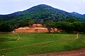


Archaeological site Juan R. Escudero, Guerrero Central Guerrero
A ceremonial centre of the Yopes, never conquered by the Aztecs, with pyramids, a ball court and temples lined up with sacred hills near Tierra Colorada.
From Chilpancingo: 50 min by car (60 km by road) How to get there ↓
Near here
See everything nearby ↓


Plan your visit to Tehuacalco
Where to stay near Tehuacalco
Compare hotels, posadas and guest houses in Tehuacalco.
Tours to Tehuacalco
A guide brings Tehuacalco to life: look for tours from Guerrero that include the site and the ride there.
 Tehuacalco Fascinating Archaeological Site Just 60 Minutes Away!
★ 5.0 (13) · From US$280
How to get to Tehuacalco
- From Chilpancingo: about 50 min by road (~60 km)
Links open a partner site. We may earn a commission if you book, at no cost to you.
Popular tours to Tehuacalco
Tours, prices and ratings from Viator, checked weekly. We may earn a commission if you book.
About Tehuacalco
Tehuacalco is an archaeological site in the Sierra Madre del Sur between Chilpancingo and Acapulco, a few kilometres off the Autopista del Sol near Tierra Colorada. It sits on a broad rise ringed by higher hills, and its builders treated that setting as sacred: four of the hills, Compuerta, Capulín, Tierra Colorada and Gavilpan, line up with the cardinal directions, and the sun rising behind Compuerta and the peaks beside it marked the equinoxes and solstices. INAH describes it as a ceremonial centre for the worship of water, hills, the sun and fertility, part of an 80-hectare settlement whose main buildings cover 12 hectares.
The site is linked to the Yopes, the people of the region the Nahuas called Yopitzingo, one of the few areas the Aztecs never managed to conquer. Building began shortly before AD 650, the great platforms went up over the following centuries and the city peaked around the year 1000; from about 1350, fighting between groups in the region led people to leave, although some caves and temples were still used for rituals afterwards. The name probably comes from Nahua groups who arrived after the Conquest and may mean 'place of the stone box' or 'place of the temples of water'. It was excavated in 2006 and 2007, the first Yope site to be studied in depth, and opened to the public in 2008.
Pyramid bases and palaces surround a large rectangular plaza. The Palace, the biggest building, has a base about 80 m on each side and was built to copy the outline of Cerro La Compuerta behind it. A ritual causeway with carved rain symbols on its steps climbs from the Palace to the Main Temple, a shrine to the rain on the most sacred hill, where a possible sacrificial stone was found. The ball court, about 38 m long, runs north to south towards that temple rather than east to west as most do. Look also for the Piedra de los Pies Labrados, a granite boulder with carved human footprints that local legend credits to a giant called Tehua, and for blocks with spirals, raindrops and Venus symbols set into the walls. An introductory room at the entrance explains the site.
How to get to Tehuacalco
Drive from Chilpancingo: 50 min, 60 km
Tehuacalco is about 2.5 km down a side road (Camino a Tehuacalco) that leaves the Autopista del Sol (95D) at about kilometre 57. Coming from Mexico City or Chilpancingo, take the Autopista del Sol towards Acapulco, leave it at the Tierra Colorada exit and follow the road to the junction at La Haciendita, which leads to the site. There is no public transport to the gate, so a car or taxi from Tierra Colorada is the practical way in. The US government currently advises against all travel to Guerrero state.
Directions to Tehuacalco on Google Maps
Distances are in a straight line; the road is usually longer.
Links open a partner site. We may earn a commission if you book, at no cost to you.
From the nearest cities to Tehuacalco
- Chilpancingo · 60 km by road, 50 min
- Acapulco · 69 km by road, 55 min
- Tlapa · about 140 km by road, ~2 h
Drive times by road from OpenStreetMap, without traffic or stops. Times marked ~ are estimated from the straight-line distance.
Before you go to Tehuacalco: hours, prices and tips
- Hours
- Tuesday to Sunday, 9am to 5pm; last entry 4pm. Closed Mondays. INAH · checked Oct 2026
- Entry
- 145 pesos for foreign visitors and 80 pesos for Mexican visitors. INAH · checked Oct 2026
- Rules
- No smoking, food, pets or flash photography; professional cameras pay a fee. INAH · checked Oct 2026
Hours and prices change, especially around holidays. Each fact links to where we checked it.
Visiting Tehuacalco: what to see and do
Walk the great plaza, ringed by pyramid bases and lined up with the sacred hills on the horizon.
Climb the ritual causeway, with rain symbols carved on its steps, from the Palace to the Main Temple.
See the ball court, unusually aimed north towards the rain shrine.
Find the Piedra de los Pies Labrados, the boulder with carved footprints.
Look for carved spirals, raindrops and Venus symbols set into the building walls.
Start at the introductory room to understand the Yopes and their calendar.
Plan your trip
Places to stay in Tehuacalco
Compare hotels, posadas, and rentals in and around Tehuacalco.
Tours & activities
A guide brings Tehuacalco to life: look for tours from Guerrero that include the site and the ride there.
Mobile data
Signal can drop away from Guerrero: download a map of the way to Tehuacalco before you set out, or carry an eSIM with data.
Links open a partner site. We may earn a commission if you book, at no cost to you.
Photos
Closest to Tehuacalco
-
Chilpancingo · City · 41 km away
-
El Santuario · Landmark · 43 km away
-
Tixtla de Guerrero · Town · 44 km away
-
Grutas de Juxtlahuaca · Cave · 46 km away
Near Tehuacalco


Drive times by road from OpenStreetMap, without traffic. Times marked ~ are estimated from the straight-line distance.
Lists with Tehuacalco
Ruins in Guerrero · 4Location from OpenStreetMap. Written by Puebloteca.