
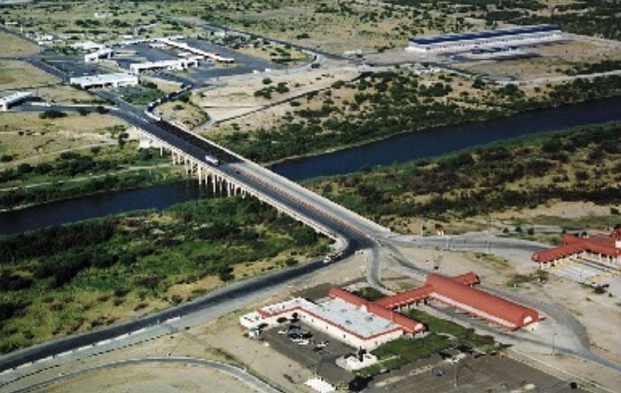
Village Anáhuac, Nuevo León
Nuevo León's small border port facing Laredo, Texas, refounded in 1992 and named for Columbus's 500th anniversary; a quieter crossing than Nuevo Laredo.
From Nuevo Laredo: 35 min by car (40 km by road) How to get there ↓
Plan your visit to Colombia
Where to stay near Colombia
Compare hotels, posadas and guest houses in Colombia.
Tours to Colombia
Day trips and guided outings from Guerrero often include Colombia; with a local guide you can get there without a car.
How to get to Colombia
- From Nuevo Laredo: about 35 min by road (~40 km)
- Nearest airport: Piedras Negras (PDS), 39 min by car to Guerrero
Links open a partner site. We may earn a commission if you book, at no cost to you.
About Colombia
Colombia is Nuevo León's only gateway to the United States, a community of 615 people on the south bank of the Rio Grande directly across from Laredo, Texas, with Nuevo Laredo to the east and Hidalgo, Coahuila, to the west. An earlier settlement of the same name existed and had been abandoned by 1978, when the state attached it to the municipality of Anáhuac. In 1992 Nuevo León refounded it as a planned community with a clear purpose: to win a share of the import-export trade with Texas instead of relying on the crossings of neighboring Coahuila and Tamaulipas. The name honors Christopher Columbus, because the founding fell on the 500th anniversary of his landfall in the Americas. The town has a sculpture called Danza a la alegría.
A year later, in 1993, the Colombia–Solidarity international bridge opened; the City of Laredo counts it among its four bridges, the farthest northwest of them. For decades it saw little traffic. The federal government canceled its concession in 2020 after years of neglect and in 2023 handed it to Nuevo León for 30 years, renewable for another 30. Since then crossings have grown from about 3,400 to more than 5,500 a day; in August 2023 the Laredo city council approved more lanes, with the cost split equally, and in 2024 Nuevo León and Laredo backed two more bridges at the same spot. To feed it, the state built the toll-free La Gloria–Colombia highway, 102 km long, at a cost of nearly 5 billion pesos. During the pandemic the bridge also served as a cross-border vaccination point for people from Nuevo León and Nuevo Laredo.
For travelers, Colombia is mainly a calmer crossing than those in Nuevo Laredo and a curiosity on the map: a small town about 150 meters above sea level, with a hot semi-arid climate, that exists because of its customs post and its bridge. Do not expect a historic center: this is a new town, built around the customs post on the bank of the Rio Grande.
How to get to Colombia
Drive from Nuevo Laredo: 35 min, 40 km
From Nuevo Laredo take Federal Highway 2 northwest toward Piedras Negras; Colombia is about 34 km away as the crow flies, roughly 40 minutes. From Monterrey, the toll-free route is the highway to Nuevo Laredo as far as kilometer 146, then the 102 km La Gloria–Colombia road. To go on to Guerrero, Coahuila, the nearest Pueblo Mágico, keep northwest on Highway 2 for about an hour and a quarter. There is no tourist transport to the town.
Directions to Colombia on Google Maps
Distances are in a straight line; the road is usually longer.
Links open a partner site. We may earn a commission if you book, at no cost to you.
From the nearest cities to Colombia
- Nuevo Laredo · 40 km by road, 35 min
- Piedras Negras · 143 km by road, 2 h
- Sabinas · 252 km by road, 3 h 25 min
Drive times by road from OpenStreetMap, without traffic or stops. Times marked ~ are estimated from the straight-line distance.
Visiting Colombia: what to see and do
Cross or look out over the Colombia–Solidarity international bridge on the Rio Grande.
Find the Danza a la alegría sculpture.
Walk down to the bank of the Rio Grande facing Laredo, Texas.
Drive the new La Gloria–Colombia highway.
Plan your trip
Places to stay in Colombia
Compare hotels, posadas, and rentals in and around Colombia.
Tours & activities
Day trips and guided outings from Guerrero often include Colombia; with a local guide you can get there without a car.
Rental cars
Pick up a car at PDS (Piedras Negras): about 39 min by road to Guerrero, then 91 km more to Colombia, on your own schedule.
Flights
The nearest airport with scheduled flights is Piedras Negras (PDS), about 39 min by road from Guerrero, the base for Colombia.
Mobile data
Signal can drop away from Guerrero: download a map of the way to Colombia before you set out, or carry an eSIM with data.
Links open a partner site. We may earn a commission if you book, at no cost to you.
When to go to Colombia warm
Colombia shares the climate of Guerrero, 91 km away. The best months to visit are January, February, March, and December.
See the month-by-month climate of Guerrero
Weather in Colombia now and the next 7 days
Live forecast from Open-Meteo. Chance of rain is the day's highest.
The closest Pueblo Mágico: Guerrero

Guerrero is the Pueblo Mágico closest to Colombia, with places to stay, food, and more to see.
Near Colombia

Drive times by road from OpenStreetMap, without traffic. Times marked ~ are estimated from the straight-line distance.
Location from OpenStreetMap. Written by Puebloteca.