Town Anáhuac, Nuevo León
An irrigation town founded in 1933 on a radial plan drawn by federal engineers; seat of the only Nuevo León municipality on the US border.
From Nuevo Laredo: 1 h 25 min by car (72 km by road) How to get there ↓
Plan your visit to Anáhuac
Where to stay near Anáhuac
Compare hotels, posadas and guest houses in Anáhuac.
Tours to Anáhuac
Day trips around Candela sometimes stop in Anáhuac; a tour is the easy way to see it without a car.
How to get to Anáhuac
- From Nuevo Laredo: about 1 h 25 min by road (~72 km)
- Nearest airport: Nuevo Laredo (NLD), 2 h 22 min by car to Candela
Links open a partner site. We may earn a commission if you book, at no cost to you.
About Anáhuac
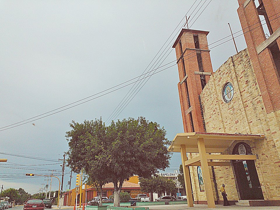
Anáhuac was born neither from a mission nor a mine but from an irrigation scheme. It was founded on May 5, 1933, while still part of Lampazos de Naranjo, as the administrative seat of National Irrigation System No. 04, the Río Salado project, and as housing for the settlers who came to farm the new fields. The Nahuatl name means place near the water. On May 29, 1935, it became the seat of a new municipality that took in the town and the communities along the Salado. The plan was drawn by engineers and technicians of the National Irrigation Commission who had trained at universities in Paris, and instead of a colonial grid the main streets fan out from the center in a radial, modernist layout that is rare in northeastern Mexico. At the hub stands the brick and stone parish church of Our Lady of Guadalupe, near the Plaza Rosita.
The town has 16,414 people and sits about 200 meters above sea level in a hot semi-arid climate with fierce summers. Water is still the constant concern. The main source of irrigation is Lake Venustiano Carranza, better known as Don Martín, which actually lies across the state line in Juárez, Coahuila; water is sent from there by canal to the Salinillas reservoir. Salinillas holds about 19 million cubic meters, supplies Anáhuac's taps and fields, and was Nuevo León's fourth-largest reservoir before the Presa Libertad was built; in March 2026 it stood at 29 percent after more than a year at critical levels. The Salado River, fed by the Camarón and Galameses creeks and the Sabinas Hidalgo River, crosses the municipality.
Farms grow wheat, sorghum and fodder and raise cattle and goats, and in town there are broom and mop workshops, sawmills and auto-parts plants. The municipality, some 4,500 km², is the only one in Nuevo León that touches the United States, with the Rio Grande as its northern edge. In 1978 the state annexed the then-abandoned community of Colombia to it, and since 1992 Anáhuac has received federal revenue from commercial traffic on the Colombia–Solidarity international bridge. Its sister city, since 2007, is Tijuana.
How to get to Anáhuac
Drive from Nuevo Laredo: 1 h 25 min, 72 km
From Nuevo Laredo there are two options. The direct one is the Anáhuac–Laredo road, whose roughly 25 km stretch along the Nuevo León–Tamaulipas line was in such bad shape that in 2017 a state legislator called it the worst road in northern Mexico; many drivers go around through Colombia instead, on Federal Highway 2, which meets the Colombia–Solidarity bridge. From the Laredo, Texas side it is 90 to 100 km, an hour to an hour and a quarter. Candela, the nearest Pueblo Mágico, is in Coahuila, reached by way of Lampazos de Naranjo in about an hour and a half.
Directions to Anáhuac on Google Maps
Distances are in a straight line; the road is usually longer.
Links open a partner site. We may earn a commission if you book, at no cost to you.
From the nearest cities to Anáhuac
- Nuevo Laredo · 72 km by road, 1 h 25 min
- Sabinas · 137 km by road, 2 h 10 min
- Monclova · about 175 km by road, ~2 h 35 min
Drive times by road from OpenStreetMap, without traffic or stops. Times marked ~ are estimated from the straight-line distance.
Visiting Anáhuac: what to see and do
Walk the radial streets fanning out from the center, laid out by the National Irrigation Commission.
Visit the parish church of Our Lady of Guadalupe.
Sit for a while in the Plaza Rosita.
Look out over the Salinillas reservoir that supplies the municipality.
See the canals and wheat and sorghum fields of the irrigation district.
Plan your trip
Places to stay in Anáhuac
Compare hotels, posadas, and rentals in and around Anáhuac.
Tours & activities
Day trips around Candela sometimes stop in Anáhuac; a tour is the easy way to see it without a car.
Rental cars
Pick up a car at NLD (Nuevo Laredo): about 2 h 22 min by road to Candela, then 69 km more to Anáhuac, on your own schedule.
Flights
The nearest airport with scheduled flights is Nuevo Laredo (NLD), about 2 h 22 min by road from Candela, the base for Anáhuac.
Mobile data
Signal can drop away from Candela: download a map of the way to Anáhuac before you set out, or carry an eSIM with data.
Links open a partner site. We may earn a commission if you book, at no cost to you.
When to go to Anáhuac warm
Anáhuac shares the climate of Candela, 69 km away. The best months to visit are January, February, March, and December.
See the month-by-month climate of Candela
Weather in Anáhuac now and the next 7 days
Live forecast from Open-Meteo. Chance of rain is the day's highest.
The closest Pueblo Mágico: Candela

Candela is the Pueblo Mágico closest to Anáhuac, with places to stay, food, and more to see.
Closest to Anáhuac
-
Lampazos de Naranjo · Town · 44 km away

Near Anáhuac


Drive times by road from OpenStreetMap, without traffic. Times marked ~ are estimated from the straight-line distance.
Location from OpenStreetMap. Written by Puebloteca.