

Landmark Mérida, Yucatán Municipality of Mérida Mérida and around
Historic barrio on Calle 60 near Paseo de Montejo, with an 18th-century church, a palm-lined park and a market known for regional food stalls.
From Valladolid: 2 h 10 min by car (163 km by road) How to get there ↓
Near here
See everything nearby ↓


Plan your visit to Barrio de Santa Ana
Where to stay near Barrio de Santa Ana
Compare hotels, posadas and guest houses in Barrio de Santa Ana.
Tours to Barrio de Santa Ana
Look for tours of the area around Motul that stop at Barrio de Santa Ana.
 Tours from Merida
From Merida: Chichen Itza Tour, Izamal, Cenote Ik Kil and Food
★ 4.9 (578) · From US$74
How to get to Barrio de Santa Ana
- From Valladolid: about 2 h 10 min by road (~163 km)
- Nearest airport: Mérida (MID), 47 min by car to Motul
Links open a partner site. We may earn a commission if you book, at no cost to you.
Tours from Merida, near Barrio de Santa Ana


Tours, prices and ratings from Viator, checked weekly. We may earn a commission if you book.
About Barrio de Santa Ana
Santa Ana is one of the historic barrios on the north side of Mérida's centre, about 1 km up Calle 60 from the Plaza Grande, around the corner of Calles 60 and 47, almost at the start of Paseo de Montejo. Its heart is a small group of landmarks: the church of Santa Ana, the palm-lined park in front of it with a statue of Andrés Quintana Roo at the centre, and the Santa Ana market beside them. It makes an easy stop between the cathedral and the Paseo, and one of the best-known places in the centre to sit down to a cheap Yucatecan meal.
The site began as a small square at the centre of a pre-Hispanic Maya settlement, and in colonial times it became a modest barrio of artisans and day labourers. Before 1600 it was probably part of neighbouring Santa Lucía, and its plots were used to grow fruit and vegetables for the city. Its growth came in the early 18th century, when Governor Antonio de Figueroa y Silva laid out a straight street north from the bishop's palace with stone arches at either end, and in 1729 ordered a church built on the site of an old open chapel. The church was finished in 1733 and is believed to stand on a Maya platform. Figueroa y Silva did not see it completed: he died in the forests of eastern Yucatán after a campaign against the Belize buccaneers, and a plaque on the façade says his remains rest inside.
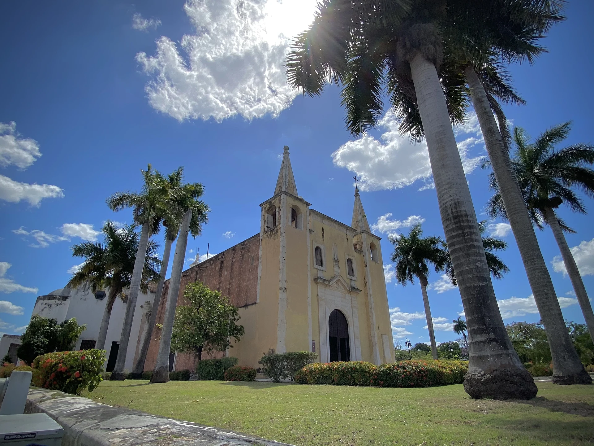
Today the church, with its two slender pointed towers and yellow façade, still faces the park, and many of the old houses around it have become shops and restaurants. The city government keeps the park and the market in good order, and since 2012 the barrio has been part of the circuit of the Noche Blanca arts night. The market is the main draw for visitors: its open dining area fills with families eating at the stalls, and the park is ringed with restaurants serving regional cooking, which a city councillor once called one of Mérida's most important food hubs. Santa Ana was also among the barrios that applied to the federal Barrio Mágico programme after La Ermita was named in 2023.
How to get to Barrio de Santa Ana
Drive from Valladolid: 2 h 10 min, 163 km
From the Plaza Grande walk north along Calle 60 for about 1 km (12–15 minutes), past the Parque Hidalgo and Santa Lucía; the church and park are at Calle 60 and 47. The start of Paseo de Montejo is just to the east.
Directions to Barrio de Santa Ana on Google Maps
Distances are in a straight line; the road is usually longer.
Links open a partner site. We may earn a commission if you book, at no cost to you.
From the nearest cities to Barrio de Santa Ana
- Valladolid · 163 km by road, 2 h 10 min
- Campeche · 173 km by road, 2 h 10 min
- Tizimín · 165 km by road, 2 h 30 min
Drive times by road from OpenStreetMap, without traffic or stops. Times marked ~ are estimated from the straight-line distance.
Visiting Barrio de Santa Ana: what to see and do
Look at the church of Santa Ana (1729–1733) and the plaque to Governor Figueroa y Silva on its façade.
Sit in the park around the statue of Andrés Quintana Roo.
Eat at the stalls of the Santa Ana market: cochinita tortas and tacos are on offer.
Walk one block east to the start of Paseo de Montejo.
Plan your trip
Places to stay in Barrio de Santa Ana
Compare hotels, posadas, and rentals in and around Barrio de Santa Ana.
Tours & activities
Look for tours of the area around Motul that stop at Barrio de Santa Ana.
Rental cars
Pick up a car at MID (Mérida): about 47 min by road to Motul, then 38 km more to Barrio de Santa Ana, on your own schedule.
Flights
The nearest airport with scheduled flights is Mérida (MID), about 47 min by road from Motul, the base for Barrio de Santa Ana.
Mobile data
Signal can drop away from Motul: download a map of the way to Barrio de Santa Ana before you set out, or carry an eSIM with data.
Links open a partner site. We may earn a commission if you book, at no cost to you.
Photos
When to go to Barrio de Santa Ana warm
Barrio de Santa Ana shares the climate of Motul, 38 km away. The best months to visit are January, February, November, and December.
See the month-by-month climate of Motul
Weather in Barrio de Santa Ana now and the next 7 days
Live forecast from Open-Meteo. Chance of rain is the day's highest.
The closest Pueblo Mágico: Motul

Motul is the Pueblo Mágico closest to Barrio de Santa Ana, with places to stay, food, and more to see.
Also close to
Closest to Barrio de Santa Ana
-
Palacio Cantón · Landmark · 0 km away
-
Paseo de Montejo · Landmark · 0 km away
-
Arcos de Mérida · Landmark · 1 km away
-
Barrio de Santa Lucía · Landmark · 1 km away
-
Barrio de Santiago · Landmark · 1 km away
-
Casa de Montejo · Landmark · 1 km away
-
Catedral de San Ildefonso · Landmark · 1 km away
-
Mercado Lucas de Gálvez · Landmark · 1 km away


Near Barrio de Santa Ana


Drive times by road from OpenStreetMap, without traffic. Times marked ~ are estimated from the straight-line distance.
Location from OpenStreetMap. Written by Puebloteca.