

Landmark Morelia, Michoacán Municipality of Morelia Morelia and around
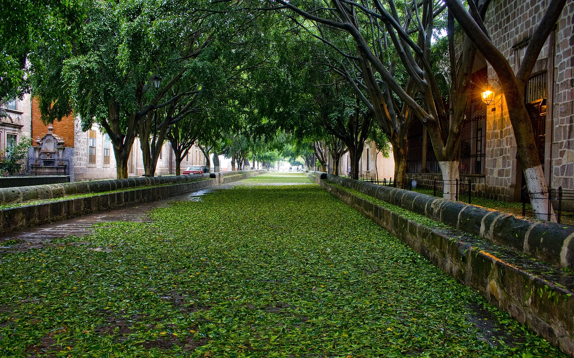
A stone-paved walkway of 1732 under ash trees, running about 500 m from the famous Fuente de las Tarascas to the Santuario de Guadalupe.
From Uriangato: 50 min by car (57 km by road) How to get there ↓
Near here
See everything nearby ↓


Plan your visit to Calzada Fray Antonio de San Miguel and Fuente de las Tarascas
Where to stay near Calzada Fray Antonio de San Miguel and Fuente de las Tarascas
Compare hotels, posadas and guest houses in Calzada Fray Antonio de San Miguel and Fuente de las Tarascas.
Tours to Calzada Fray Antonio de San Miguel and Fuente de las Tarascas
Look for tours of the area around Cuitzeo that stop at Calzada Fray Antonio de San Miguel and Fuente de las Tarascas.
 Tours from Morelia
Morelia City Tour
★ 4.9 (115) · From US$33
How to get to Calzada Fray Antonio de San Miguel and Fuente de las Tarascas
- From Uriangato: about 50 min by road (~57 km)
- Nearest airport: Morelia (MLM), 26 min by car to Cuitzeo
Links open a partner site. We may earn a commission if you book, at no cost to you.
Tours from Morelia, near Calzada Fray Antonio de San Miguel and Fuente de las Tarascas


Tours, prices and ratings from Viator, checked weekly. We may earn a commission if you book.
About Calzada Fray Antonio de San Miguel and Fuente de las Tarascas
The Calzada Fray Antonio de San Miguel, also known as the Calzada de San Diego or de Guadalupe, is a wide pedestrian walkway on the east side of the historic centre. It was laid out in 1732 under Bishop Juan José de Escalona y Calatayud to link the city, then Valladolid, with the church of the Virgin of Guadalupe, which at the time stood out in the fields; the Santuario de Guadalupe, also called the Templo de San Diego, still closes its eastern end. Later in the century it was renovated and given cantera stone paving and stone benches, and it takes its name from Bishop Fray Antonio de San Miguel, who restored it and also paid for the rebuilding of the aqueduct in the 1780s. A row of ash trees shades its whole length, and it is lined with 18th- and 19th-century summer houses. Measured on OpenStreetMap it runs just under 500 m, from Avenida Acueducto to the small square in front of the sanctuary.
At the western end, where Avenida Madero meets Avenida Acueducto and the aqueduct arches end, stands the Fuente de las Tarascas, Morelia's best-known fountain. The first version, installed in 1931 and made by Antonio Silva Díaz and Benigno Lara, was a painted concrete group of three kneeling, bare-breasted women in blue rebozos holding up a basket of fruit. It drew criticism for its nudity, and in August 1965 the mayor had it taken away and replaced with a fountain known as El Huarache; the old figures ended up at the city's fairground. El Huarache was never liked, and in 1983 and 1984 the sculptor José Luis Padilla Retana made a new bronze group on the same theme, paid for with public donations and unveiled on 18 May 1984.
The bronze women are popularly identified as three Purépecha princesses of legend, Atzimba, Eréndira and Tzetzangari; their faces were modelled on a woman from the island of Yunuén in Lake Pátzcuaro. They lift a basket of regional produce, including apples, maize and avocados, as a sign of the land's abundance, and a replica was given to Buenos Aires in 1998. Just north of the fountain is the narrow Callejón del Romance, a pink-stone alley with fountains and lamps named after a poem about the city by the Morelia poet Lucas Ortiz.
How to get to Calzada Fray Antonio de San Miguel and Fuente de las Tarascas
Drive from Uriangato: 50 min, 57 km
The Fuente de las Tarascas is about 1 km east of the cathedral, at the point where Avenida Madero Oriente meets Avenida Acueducto; walk east along Madero from the Plaza de Armas, past the Museo del Dulce. The Calzada starts beside the fountain on the south side of Avenida Acueducto and runs east, on foot only, to the Santuario de Guadalupe on Avenida Tata Vasco.
Directions to Calzada Fray Antonio de San Miguel and Fuente de las Tarascas on Google Maps
Distances are in a straight line; the road is usually longer.
Links open a partner site. We may earn a commission if you book, at no cost to you.
From the nearest cities to Calzada Fray Antonio de San Miguel and Fuente de las Tarascas
- Uriangato · 57 km by road, 50 min
- Pátzcuaro · 58 km by road, 50 min
- Acámbaro · 75 km by road, 1 h 5 min
Drive times by road from OpenStreetMap, without traffic or stops. Times marked ~ are estimated from the straight-line distance.
Before you go to Calzada Fray Antonio de San Miguel and Fuente de las Tarascas: hours, prices and tips
- Entry
- Free: the Calzada is a public pedestrian walkway and the fountain stands on a public roundabout. Programa Destinos México · checked Oct 2026
- Time needed
- The Calzada is just under 500 m long, a 10-minute stroll each way. OpenStreetMap · checked Oct 2026
- Rules
- The fountain is a frequent meeting point for protests and marches. Wikipedia · checked Oct 2026
Hours and prices change, especially around holidays. Each fact links to where we checked it.
Visiting Calzada Fray Antonio de San Miguel and Fuente de las Tarascas: what to see and do
Walk the shaded stone walkway from the Fuente de las Tarascas to the Santuario de Guadalupe.
Photograph the bronze Tarascas with the aqueduct arches behind them.
Sit on the old stone benches under the ash trees.
Look at the 18th- and 19th-century summer houses along the Calzada.
Detour into the Callejón del Romance, just north of the fountain.
Plan your trip
Places to stay in Calzada Fray Antonio de San Miguel and Fuente de las Tarascas
Compare hotels, posadas, and rentals in and around Calzada Fray Antonio de San Miguel and Fuente de las Tarascas.
Tours & activities
Look for tours of the area around Cuitzeo that stop at Calzada Fray Antonio de San Miguel and Fuente de las Tarascas.
Rental cars
Pick up a car at MLM (Morelia): about 26 min by road to Cuitzeo, then 30 km more to Calzada Fray Antonio de San Miguel and Fuente de las Tarascas, on your own schedule.
Flights
The nearest airport with scheduled flights is Morelia (MLM), about 26 min by road from Cuitzeo, the base for Calzada Fray Antonio de San Miguel and Fuente de las Tarascas.
Mobile data
Signal can drop away from Cuitzeo: download a map of the way to Calzada Fray Antonio de San Miguel and Fuente de las Tarascas before you set out, or carry an eSIM with data.
Links open a partner site. We may earn a commission if you book, at no cost to you.
Photos
When to go to Calzada Fray Antonio de San Miguel and Fuente de las Tarascas mild
Calzada Fray Antonio de San Miguel and Fuente de las Tarascas shares the climate of Cuitzeo, 30 km away. The best months to visit are January, March, April, and November.
See the month-by-month climate of Cuitzeo
Weather in Calzada Fray Antonio de San Miguel and Fuente de las Tarascas now and the next 7 days
Live forecast from Open-Meteo. Chance of rain is the day's highest.
The closest Pueblo Mágico: Cuitzeo

Cuitzeo is the Pueblo Mágico closest to Calzada Fray Antonio de San Miguel and Fuente de las Tarascas, with places to stay, food, and more to see.
Also close to
- Tzintzuntzan · Michoacán · 43 km away
- Pátzcuaro · Michoacán · 49 km away
- Yuriria · Guanajuato · 57 km away
- Santa Clara del Cobre · Michoacán · 58 km away
- Tacámbaro · Michoacán · 59 km away
Closest to Calzada Fray Antonio de San Miguel and Fuente de las Tarascas
-
Acueducto de Morelia · Landmark · 0 km away
-
Bosque Cuauhtémoc · Nature reserve · 0 km away
-
Santuario de Guadalupe (San Diego) · Landmark · 0 km away
-
Catedral de Morelia · Landmark · 1 km away
-
Morelia · City · 1 km away
-
Museo Casa Natal de Morelos · Landmark · 1 km away
-
Museo Regional Michoacano · Landmark · 1 km away
-
Museo del Dulce (Dulces Morelianos de la Calle Real) · Landmark · 1 km away


Near Calzada Fray Antonio de San Miguel and Fuente de las Tarascas


Drive times by road from OpenStreetMap, without traffic. Times marked ~ are estimated from the straight-line distance.
Location from OpenStreetMap. Written by Puebloteca.