


Town Solidaridad, Quintana Roo Municipality of Solidaridad Riviera Maya
Playa del Carmen's gated hotel zone south of the ferry pier, with a long beach, a golf course and the free Xaman-Há Maya ruins.
From Playa del Carmen: 10 min by car (5 km by road) How to get there ↓
Near here
See everything nearby ↓


Plan your visit to Playacar
Where to stay near Playacar
Compare hotels, posadas and guest houses in Playacar.
Tours to Playacar
Day trips around Cozumel sometimes stop in Playacar; a tour is the easy way to see it without a car.
 Private one-way transport from Tulum Airport
★ 5.0 (20) · From US$57
How to get to Playacar
- From Playa del Carmen: about 10 min by road (~5 km)
- Nearest airport: Cozumel (CZM), 7 min by car to Cozumel
Links open a partner site. We may earn a commission if you book, at no cost to you.
Popular tours to Playacar

Tours, prices and ratings from Viator, checked weekly. We may earn a commission if you book.
About Playacar
Playacar is the gated resort district of Playa del Carmen, lying just south of the city centre and the Cozumel ferry pier. It has three controlled entrances and two parts: Phase I, a strip of villas and apartments along the sea close to downtown, and the larger Phase II, built around an 18-hole golf course and home to most of the all-inclusive resorts. It is roughly a 40-minute drive from Cancún.
The district sits on top of Xaman-Há, the Postclassic Maya port (about 1200–1526) from which pilgrims crossed to Cozumel to honour the goddess Ixchel; the Spanish saw it in 1518 and it was abandoned after their arrival. The Carnegie Institution of Washington studied it from 1918 and INAH began rescue work in 1978. Of eight original building groups, three survive (C, E and F), small temples and platforms set among the houses and gardens, some fenced and some open, and free to see. The golf course, laid out by Robert von Hagge and opened in 1994, threads through jungle with cenotes and mangroves; it now operates as the Hard Rock Golf Club. The Xaman-Ha bird sanctuary on Paseo Xaman-Há keeps native and migratory birds.
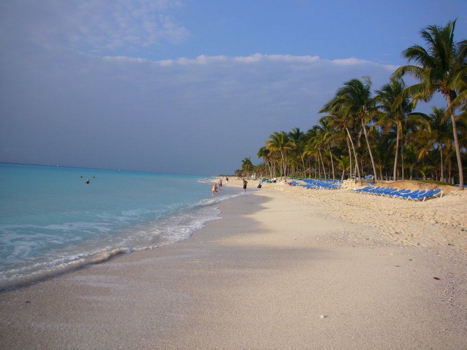
The beach in front of Playacar is long and quieter than the town beaches, with loungers and resort bars along the Phase II stretch. Walkers and cyclists usually get through the gates to visit the ruins, while car access is restricted to guests and residents, so the easiest approach from Quinta Avenida is on foot or by bike.
How to get to Playacar
Drive from Playa del Carmen: 10 min, 5 km
Playacar begins just south of Playa del Carmen's ferry pier. Phase I is entered from Avenida 10 just south of Calle 1 Sur; Phase II is at the end of Avenida 10. From the pier it is a 15–20 minute walk or a short taxi ride to the beach; Wikivoyage put a taxi from downtown at about US$7. From Highway 307 follow signs for Playacar south of the Avenida Juárez exit.
Directions to Playacar on Google Maps
Distances are in a straight line; the road is usually longer.
Links open a partner site. We may earn a commission if you book, at no cost to you.
From the nearest cities to Playacar
- Playa del Carmen · 5 km by road, 10 min
- Cancún · 69 km by road, 1 h
- Valladolid · 143 km by road, 1 h 50 min
Drive times by road from OpenStreetMap, without traffic or stops. Times marked ~ are estimated from the straight-line distance.
Before you go to Playacar: hours, prices and tips
- Entry
- The Xaman-Há ruins inside Playacar are free to visit. Loco Gringo · checked Oct 2026
- Best time of day
- Early morning gives the best light at the ruins and fewer people. Infoviajera · checked Oct 2026
- Best season
- Local schools hold public events at the ruins on the summer and winter solstices. Loco Gringo · checked Oct 2026
- Rules
- Car entry to the gated community is restricted to guests and residents; visitors to the ruins go on foot or by bike. Infoviajera · checked Oct 2026
Hours and prices change, especially around holidays. Each fact links to where we checked it.
Visiting Playacar: what to see and do
Xaman-Há ruins, groups E and F along Paseo Xaman-Há, about a mile from the Phase II gate
Group C, reached by a signed jungle path off Paseo Xaman-Há
The long beach south of the ferry pier
The Xaman-Ha bird sanctuary
A round at the von Hagge golf course (Hard Rock Golf Club)
Plan your trip
Places to stay in Playacar
Compare hotels, posadas, and rentals in and around Playacar.
Tours & activities
Day trips around Cozumel sometimes stop in Playacar; a tour is the easy way to see it without a car.
Rental cars
Pick up a car at CZM (Cozumel): about 7 min by road to Cozumel, then 21 km more to Playacar, on your own schedule.
Flights
The nearest airport with scheduled flights is Cozumel (CZM), about 7 min by road from Cozumel, the base for Playacar.
Mobile data
Signal can drop away from Cozumel: download a map of the way to Playacar before you set out, or carry an eSIM with data.
Links open a partner site. We may earn a commission if you book, at no cost to you.
Photos
When to go to Playacar warm
Playacar shares the climate of Cozumel, 21 km away. The best months to visit are February, March, April, and May.
See the month-by-month climate of Cozumel
Weather in Playacar now and the next 7 days
Live forecast from Open-Meteo. Chance of rain is the day's highest.
The closest Pueblo Mágico: Cozumel

Cozumel is the Pueblo Mágico closest to Playacar, with places to stay, food, and more to see.
Also close to
- Tulum · Quintana Roo · 60 km away
- Isla Mujeres · Quintana Roo · 78 km away
Closest to Playacar
-
Playa del Carmen · City · 1 km away
-
Quinta Avenida · Landmark · 1 km away
-
Punta Esmeralda · Beach · 5 km away
-
Xplor · Nature reserve · 5 km away
-
Río Secreto · Cave · 6 km away
-
Xcaret · Nature reserve · 6 km away
-
Xenses · Nature reserve · 6 km away
-
Chankanaab · Nature reserve · 21 km away


Near Playacar


Drive times by road from OpenStreetMap, without traffic. Times marked ~ are estimated from the straight-line distance.
Location from OpenStreetMap. Written by Puebloteca.