Lake Cajeme, Sonora Municipality of Cajeme
Sonora's largest reservoir, on the Yaqui River north of Ciudad Obregón: a lookout over the dam, black bass fishing and lakeshore camping.
From Ciudad Obregón: 45 min by car (43 km by road) How to get there ↓
Plan your visit to Presa Álvaro Obregón (El Oviáchic)
Where to stay near Presa Álvaro Obregón (El Oviáchic)
Compare hotels, posadas and guest houses in Presa Álvaro Obregón (El Oviáchic).
Tours to Presa Álvaro Obregón (El Oviáchic)
Day trips and guided outings from Sonora often include Presa Álvaro Obregón (El Oviáchic); with a local guide you can get there without a car.
How to get to Presa Álvaro Obregón (El Oviáchic)
- From Ciudad Obregón: about 45 min by road (~43 km)
Links open a partner site. We may earn a commission if you book, at no cost to you.
About Presa Álvaro Obregón (El Oviáchic)
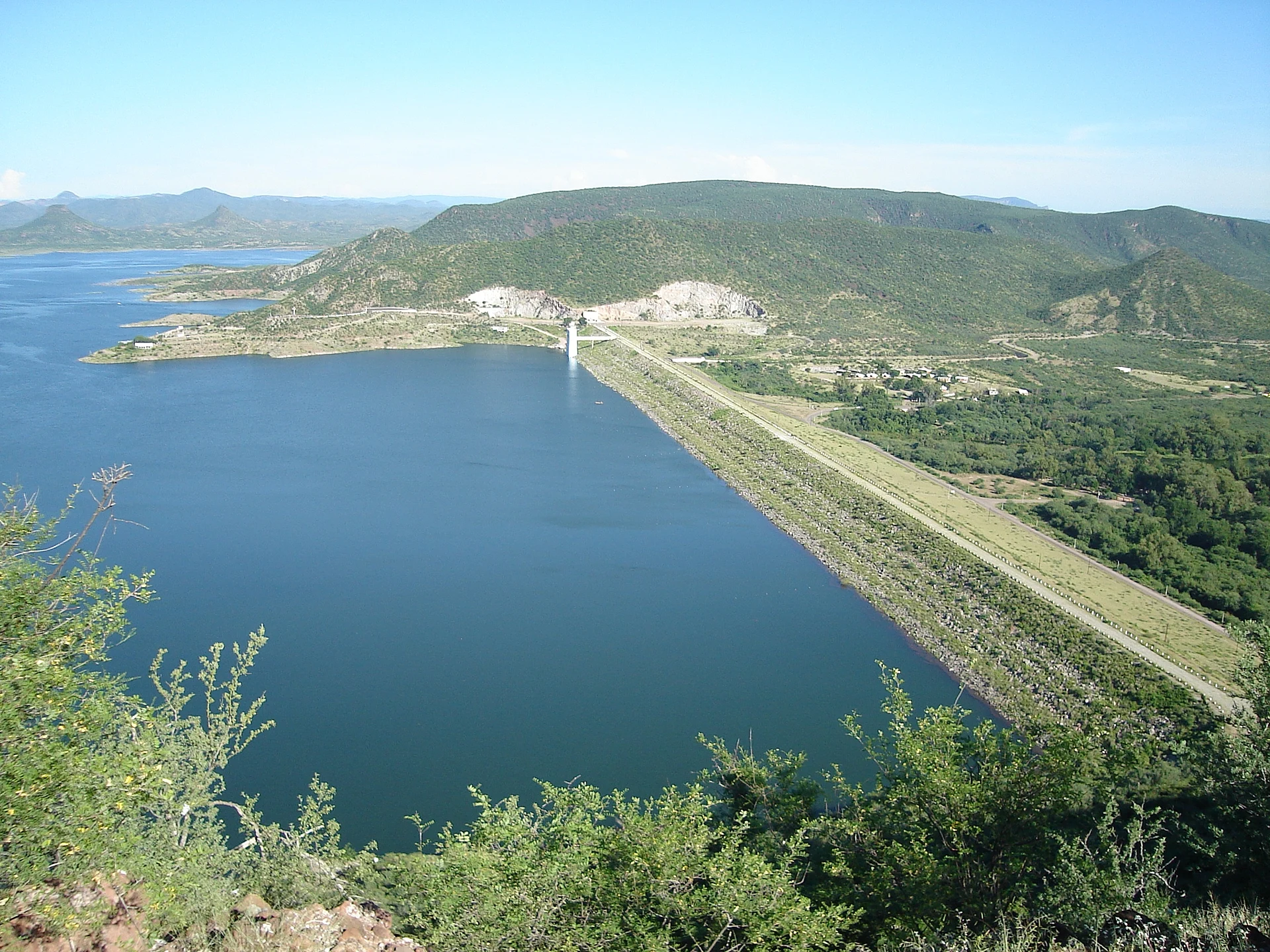
El Oviáchic, as everyone in southern Sonora calls the Álvaro Obregón Dam, holds back the Yaqui River at the point where it leaves the foothills of the Sierra Madre Occidental and widens toward the coastal plain. The name is Yaqui for "the difficult one." Built between 1947 and 1952 under President Miguel Alemán and inaugurated on August 28, 1957, it is an embankment dam 1,457 meters long and 360 meters wide at the base, wedged between the Oviáchic and La Cantera hills. Its hydroelectric plant started running in April 1958.
At full capacity the reservoir stores 2,989 million cubic meters over roughly 205 square kilometers, about 21 km long and up to 6.75 km wide, which makes it the largest reservoir in the state. Working with La Angostura and El Novillo dams upstream, it evens out the river's flow, prevents floods, generates power and above all irrigates the Yaqui Valley farms around Ciudad Obregón. The original village of Buena Vista was flooded when the lake filled, after its people were moved; in dry years the cross of its old church shows above the water. Today's Buenavista, on the shore, depends heavily on fishing, with around a hundred families living from it.
Water levels swing hard with drought, so set your expectations. In April 2024 the dam was at 12 percent and local fishermen stopped going out because their boats grounded; a year later it stood near 15 percent. When the lake is low you get bare shorelines and dry hills rather than a brimming reservoir, though the view from above is still wide.
A day trip here is simple. Stop at the scenic lookout at the entrance for the view of the dam wall and the water between the hills, look at the spillway, then head down to the shore. Anglers come for black bass, with tournaments through the year, plus catfish and tilapia; there is boating, kayaking and water skiing, and people camp along the banks. The hills are made of Precambrian metamorphic rock, Mesozoic marine sediments and volcanic agglomerates.
How to get to Presa Álvaro Obregón (El Oviáchic)
Drive from Ciudad Obregón: 45 min, 43 km
The dam is about 40 km north of Ciudad Obregón, the nearest city (El Imparcial puts it at 42 km northeast, by Buenavista); allow about an hour. The last stretch is state road SON 121, and the lookout is at the entrance to the dam. From Hermosillo, first drive south on Highway 15 to Ciudad Obregón. San Carlos, the nearest Pueblo Mágico, is about three hours away: back to Ciudad Obregón, then north on Highway 15 past Guaymas.
Directions to Presa Álvaro Obregón (El Oviáchic) on Google Maps
Distances are in a straight line; the road is usually longer.
Links open a partner site. We may earn a commission if you book, at no cost to you.
From the nearest cities to Presa Álvaro Obregón (El Oviáchic)
- Ciudad Obregón · 43 km by road, 45 min
- Navojoa · 106 km by road, 1 h 30 min
- Guaymas · 146 km by road, 2 h
Drive times by road from OpenStreetMap, without traffic or stops. Times marked ~ are estimated from the straight-line distance.
Visiting Presa Álvaro Obregón (El Oviáchic): what to see and do
Stop at the scenic lookout by the entrance for the dam wall and the reservoir between the hills.
Look at the dam's spillway.
Fish for black bass, catfish or tilapia from a boat.
Paddle a kayak or take a boat out on the reservoir.
Camp on the shore.
Look for the cross of the drowned village of Buena Vista when the water is low.
Plan your trip
Places to stay in Presa Álvaro Obregón (El Oviáchic)
Compare hotels, posadas, and rentals in and around Presa Álvaro Obregón (El Oviáchic).
Tours & activities
Day trips and guided outings from Sonora often include Presa Álvaro Obregón (El Oviáchic); with a local guide you can get there without a car.
Travel insurance
If you plan on swimming or kayaking at Presa Álvaro Obregón (El Oviáchic), check that your policy covers it: some plans leave adventure activities out.
Mobile data
Signal can drop away from Sonora: download a map of the way to Presa Álvaro Obregón (El Oviáchic) before you set out, or carry an eSIM with data.
Links open a partner site. We may earn a commission if you book, at no cost to you.
Closest to Presa Álvaro Obregón (El Oviáchic)


Near Presa Álvaro Obregón (El Oviáchic)

Drive times by road from OpenStreetMap, without traffic. Times marked ~ are estimated from the straight-line distance.
Location from OpenStreetMap. Written by Puebloteca.