
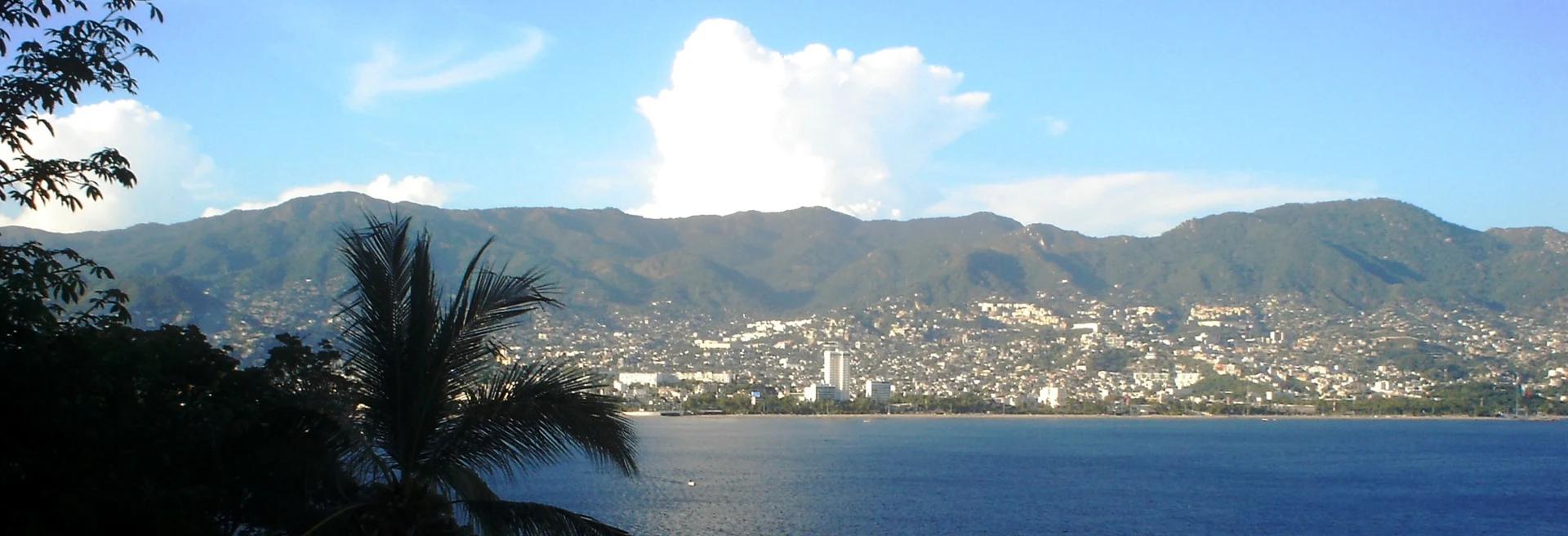
Nature reserve Acapulco de Juárez, Guerrero Municipality of Acapulco de Juárez Acapulco Bay
The hills ringing Acapulco Bay, a national park since 1980, with tropical forest, lookouts and the Palma Sola petroglyphs.
From Acapulco: about 5 min by road (~5 km) How to get there ↓
Near here
See everything nearby ↓


Plan your visit to Parque Nacional El Veladero
Where to stay near Parque Nacional El Veladero
Compare hotels, posadas and guest houses in Parque Nacional El Veladero.
Tours to Parque Nacional El Veladero
Day trips and guided outings from Guerrero often include Parque Nacional El Veladero; with a local guide you can get there without a car.
 Tours from Acapulco
Paddle Boarding At Acapulco´s Bay
★ 5.0 (247) · From US$24
How to get to Parque Nacional El Veladero
- From Acapulco: about 5 min by road (~5 km)
Links open a partner site. We may earn a commission if you book, at no cost to you.
Tours from Acapulco, near Parque Nacional El Veladero


Tours, prices and ratings from Viator, checked weekly. We may earn a commission if you book.
About Parque Nacional El Veladero
El Veladero is the national park that protects the upper slopes of the amphitheatre of hills wrapped around Acapulco Bay. It was decreed on 18 July 1980 with about 3,159 hectares, and its high point is Cerro El Veladero, 918 metres, the mountain that rises straight behind the city. It is run by Mexico's national protected areas commission, CONANP.
The cover is medium semi-deciduous tropical forest mixed with dry deciduous forest, with scattered oaks such as Quercus affinis and Quercus laurina. More than 360 plant and animal species have been recorded, twelve of them listed as at risk: boas, green iguanas, spiny-tailed iguanas, the Mexican beaded lizard (Heloderma horridum), crested guans, ospreys and a range of raptors and songbirds. The city government reckons the park's vegetation soaks up more than two thousand tonnes of the carbon dioxide Acapulco produces.
The hill played a part in the War of Independence. In 1813 and 1814 José María Morelos and Hermenegildo Galeana used El Veladero as a barracks and supply base for their campaigns in the south, building small forts with artillery pieces, among them Fortín San Cristóbal. On 6 May 1814 royalist troops sent by José Gabriel de Armijo reached the hill, burned the settlement and took the position.
The high ground looks over Acapulco's neighbourhoods, the whole bay, Pie de la Cuesta and the Coyuca lagoon. On the southern slope, between the Independencia and Palma Sola neighbourhoods, lies the Palma Sola archaeological site: 18 granite boulders carved with human figures, mythical beings, animals and geometric shapes, dated from the Late Preclassic to the Classic period. The path to the top runs to about 500 steps.
No tourism project has ever been carried out in the park, and its biggest problem is irregular settlement: the village of El Veladero, with 735 residents in 2010, lies inside it, and land invasions keep recurring. In 2025 the city council and CONANP agreed to work together to stop them.
How to get to Parque Nacional El Veladero
The park covers the hills right behind the city: from Acapulco it is about 5 minutes and 3 km by road to its edge. The usual way in is through the Palma Sola archaeological site: from the Costera Miguel Alemán take Avenida Escudero, then Aquiles Serdán and Constituyentes to Avenida Palma Sola, and walk the last stretch uphill; a taxi can take you (Acapulco taxis are unmetered, so agree the fare first). To reach Acapulco from Mexico City, buses leave the Terminal del Sur (Taxqueña): Estrella de Oro hourly, in about five hours, plus Costa Line and ETN, on the Autopista del Sol (95D). The US State Department advises against all travel to Guerrero; go by day, in company, and ask about local conditions before heading up.
Directions to Parque Nacional El Veladero on Google Maps
Distances are in a straight line; the road is usually longer.
Links open a partner site. We may earn a commission if you book, at no cost to you.
From the nearest cities to Parque Nacional El Veladero
- Acapulco · about 5 km by road, ~5 min
- Chilpancingo · about 110 km by road, ~1 h 40 min
- Tlapa · about 205 km by road, ~3 h 5 min
Drive times by road from OpenStreetMap, without traffic or stops. Times marked ~ are estimated from the straight-line distance.
Before you go to Parque Nacional El Veladero: hours, prices and tips
- Hours
- 09:00 to 17:00. Wikivoyage · checked Oct 2026
- Time needed
- The climb to the top is about 500 steps. Wikivoyage · checked Oct 2026
Hours and prices change, especially around holidays. Each fact links to where we checked it.
Visiting Parque Nacional El Veladero: what to see and do
The Palma Sola petroglyphs, 18 carved granite boulders on the southern slope.
The view over Acapulco Bay, Pie de la Cuesta and the Coyuca lagoon from the high ground.
Cerro El Veladero, 918 metres, the summit behind the city.
The tropical forest with oaks, iguanas, boas and birds of prey.
The hill where Morelos and Galeana built their forts in 1813 and 1814.
Plan your trip
Places to stay in Parque Nacional El Veladero
Compare hotels, posadas, and rentals in and around Parque Nacional El Veladero.
Tours & activities
Day trips and guided outings from Guerrero often include Parque Nacional El Veladero; with a local guide you can get there without a car.
Travel insurance
If you plan on hiking at Parque Nacional El Veladero, check that your policy covers it: some plans leave adventure activities out.
Mobile data
Signal can drop away from Guerrero: download a map of the way to Parque Nacional El Veladero before you set out, or carry an eSIM with data.
Links open a partner site. We may earn a commission if you book, at no cost to you.
Closest to Parque Nacional El Veladero
-
Palma Sola · Archaeological site · 2 km away
-
Acapulco · City · 4 km away
-
Fuerte de San Diego (Museo Histórico de Acapulco) · Landmark · 5 km away
-
La Quebrada · Landmark · 5 km away
-
Playa Condesa · Beach · 7 km away
-
Playas Caleta y Caletilla · Beach · 7 km away
-
Isla La Roqueta · Island · 8 km away
-
Playa Icacos · Beach · 8 km away


Near Parque Nacional El Veladero



Drive times by road from OpenStreetMap, without traffic. Times marked ~ are estimated from the straight-line distance.
Lists with Parque Nacional El Veladero
Nature Parks in Guerrero · 3Location from OpenStreetMap. Written by Puebloteca.