



Landmark Michoacán Municipality of Uruapan Meseta Purépecha
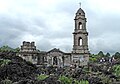
A church tower and altar rising from a sea of black lava, all that is left of a town buried by Paricutín in 1944.
From Uruapan: 1 h by car (50 km by road) How to get there ↓
Near here
See everything nearby ↓



Plan your visit to Templo de San Juan Parangaricutiro
Where to stay near Templo de San Juan Parangaricutiro
Paracho, 24 km away, is the closest town with places to stay.
Compare hotels, posadas and guest houses in Templo de San Juan Parangaricutiro.
Tours to Templo de San Juan Parangaricutiro
Look for tours of the area around Paracho that stop at Templo de San Juan Parangaricutiro.
How to get to Templo de San Juan Parangaricutiro
- From Uruapan: about 1 h by road (~50 km)
- 24 km southwest of Paracho
- Nearest airport: Uruapan (UPN), 42 min by car to Paracho
Links open a partner site. We may earn a commission if you book, at no cost to you.
About Templo de San Juan Parangaricutiro
When Paricutín began erupting in 1943, San Juan Parangaricutiro was the main town of the area, with close to 1,900 people. For more than a year its residents watched the lava creep closer. In May 1944 they left, walking for days with their revered image of the Señor de los Milagros to an old hacienda near Uruapan, where they founded Nuevo San Juan Parangaricutiro. A few weeks later, in June 1944, the lava reached the town and buried it.
Only the church held out. Today its stone facade and one complete bell tower rise out of a jagged field of black rock, along with part of a second tower that was still under construction when the volcano was born and was never finished. Behind it, the apse and the area around the altar also survive, half swallowed by rock.
It is one of the most striking sights in Mexico, and much easier to reach than the volcano itself: a walk or horse ride of about an hour from Angahuan, with a clear view of the Paricutín cone in the distance.
How to get to Templo de San Juan Parangaricutiro
Drive from Uruapan: 1 h, 50 km
From Paracho, drive about 45 minutes to Angahuan (south on Highway 37, then west just past Capácuaro). From Angahuan it is roughly an hour on foot or on horseback to the ruins; local guides offer the trip, and the lava is rough, so wear sturdy shoes.
24 km southwest of Paracho
Directions from Paracho on Google Maps
Distances are in a straight line; the road is usually longer.
Links open a partner site. We may earn a commission if you book, at no cost to you.
From the nearest cities to Templo de San Juan Parangaricutiro
- Uruapan · 50 km by road, 1 h
- Zamora · 76 km by road, 1 h 35 min
- Pátzcuaro · 105 km by road, 1 h 45 min
Drive times by road from OpenStreetMap, without traffic or stops. Times marked ~ are estimated from the straight-line distance.
Before you go to Templo de San Juan Parangaricutiro: hours, prices and tips
- Time needed
- About 30 minutes' walk downhill from the Angahuan tourist centre (uphill on the way back), plus an hour or two at the ruins. Away Go We · checked Oct 2026
- Best season
- The lava field has no shade and gets very hot in spring and early summer, before the rains. Away Go We · checked Oct 2026
- Guide or tour
- You can walk there alone on a clear horse trail; local guides and horses are offered in Angahuan and at the stalls by the ruins. Tours: Viator GetYourGuide Away Go We · checked Oct 2026
- What to bring
- Sun protection and plenty of water; the site sits at about 2,300 m, so take it slowly. Away Go We · checked Oct 2026
Hours and prices change, especially around holidays. Each fact links to where we checked it.
Visiting Templo de San Juan Parangaricutiro: what to see and do
Scramble over the lava to the bell tower and the facade.
Find the surviving altar area at the back of the church.
Take in the view of the Paricutín cone across the lava field.
Visit Angahuan's own colonial church of Santiago Apóstol before or after.
Plan your trip
Places to stay in Templo de San Juan Parangaricutiro
Compare hotels, posadas, and rentals in and around Templo de San Juan Parangaricutiro.
Tours & activities
Look for tours of the area around Paracho that stop at Templo de San Juan Parangaricutiro.
Rental cars
Pick up a car at UPN (Uruapan): about 42 min by road to Paracho, then 24 km more to Templo de San Juan Parangaricutiro, on your own schedule.
Flights
The nearest airport with scheduled flights is Uruapan (UPN), about 42 min by road from Paracho, the base for Templo de San Juan Parangaricutiro.
Mobile data
Signal can drop away from Paracho: download a map of the way to Templo de San Juan Parangaricutiro before you set out, or carry an eSIM with data.
Links open a partner site. We may earn a commission if you book, at no cost to you.
Photos
When to go to Templo de San Juan Parangaricutiro cool
Templo de San Juan Parangaricutiro shares the climate of Paracho, 24 km away. The best months to visit are January, March, April, and November.
See the month-by-month climate of Paracho
Weather in Templo de San Juan Parangaricutiro now and the next 7 days
Live forecast from Open-Meteo. Chance of rain is the day's highest.
Make Paracho your base

Templo de San Juan Parangaricutiro is an easy trip from Paracho, a Pueblo Mágico with places to stay, food, and more to see.
Also close to
- Cotija · Michoacán · 57 km away
- Santa Clara del Cobre · Michoacán · 65 km away
- Pátzcuaro · Michoacán · 67 km away
- Jiquilpan · Michoacán · 71 km away
- Tzintzuntzan · Michoacán · 71 km away
Closest to Templo de San Juan Parangaricutiro
-
Angahuan · Town · 3 km away
-
Volcán Paricutín · Mountain · 4 km away
-
Zacán · Town · 5 km away
-
Nurío · Town · 18 km away
-
Cocucho · Town · 19 km away
-
Capácuaro · Town · 20 km away
-
Parque Nacional Barranca del Cupatitzio · Nature reserve · 22 km away · Michoacán
-
Barrio de San Pedro · Landmark · 23 km away · Michoacán


Near Templo de San Juan Parangaricutiro


Drive times by road from OpenStreetMap, without traffic. Times marked ~ are estimated from the straight-line distance.
Something wrong or missing on this page? Suggest a fix or addition
Location from OpenStreetMap. Written by Puebloteca.