

Mountain Michoacán Municipality of Uruapan Meseta Purépecha
The volcano that rose from a cornfield in 1943: ride or hike across the lava from Angahuan to its still-steaming crater.
From Uruapan: 1 h by car (49 km by road) How to get there ↓
Near here
See everything nearby ↓



Plan your visit to Volcán Paricutín
Where to stay near Volcán Paricutín
Paracho, 27 km away, is the closest town with places to stay.
Compare hotels, posadas and guest houses in Volcán Paricutín.
Tours to Volcán Paricutín
Day trips and guided outings from Paracho often include Volcán Paricutín; with a local guide you can get there without a car.
How to get to Volcán Paricutín
- From Uruapan: about 1 h by road (~49 km)
- 27 km southwest of Paracho
- Nearest airport: Uruapan (UPN), 42 min by car to Paracho
Links open a partner site. We may earn a commission if you book, at no cost to you.
About Volcán Paricutín
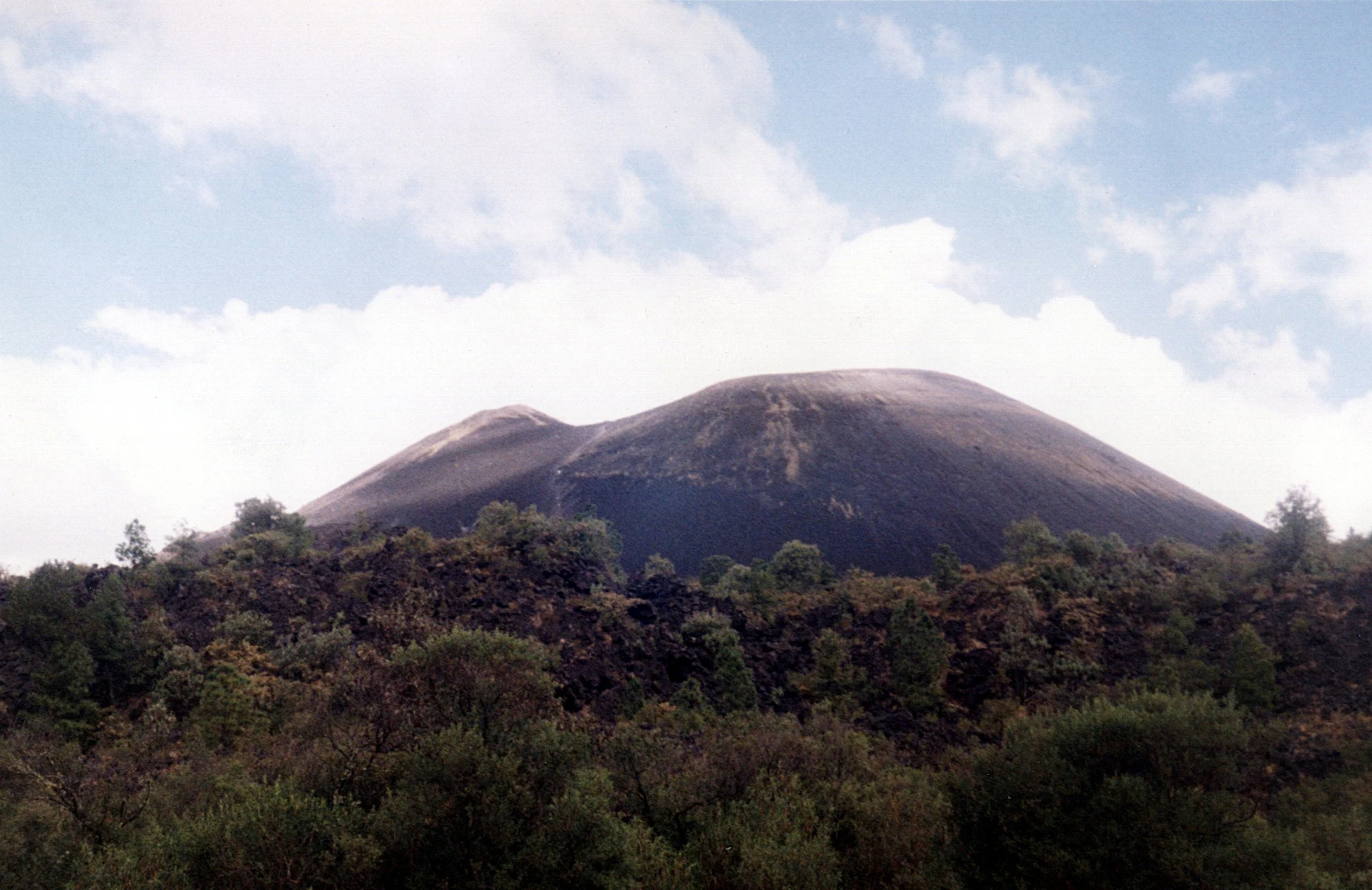
On the afternoon of February 20, 1943, a farmer named Dionisio Pulido watched the ground split open in his cornfield near the village of Parangaricutiro. Within a day a cone of ash stood about 30 meters high; by the end of the first year it was more than 300. Paricutín kept erupting for nine years, until 1952, and for a long time was known as the world's youngest volcano.
Scientists from around the world came to watch, and it became the first eruption of its kind documented from birth to end. Its lava buried two villages, Paricutín and San Juan Parangaricutiro, whose people were evacuated and resettled. The cone rose 424 meters above the original fields, though only about 220 meters now stand above the lava that piled around its base. The crater is about 250 meters across, and steam still seeps from the rim.
Today the volcano is quiet and one of the great adventures of the Purépecha highlands. From the village of Angahuan, local guides lead you on horseback or on foot across black lava and ash to the base of the cone, then up its loose slopes to walk around the crater, with Pico de Tancítaro rising behind.
How to get to Volcán Paricutín
Drive from Uruapan: 1 h, 49 km
Drive south from Paracho on Highway 37 toward Uruapan and, just past Capácuaro, take the paved road west to Angahuan (about 19 kilometers); the whole drive is roughly 45 minutes. In Angahuan, guides and horses are hired at the tourist center or in the village; the volcano cannot be reached by road.
27 km southwest of Paracho
Directions from Paracho on Google Maps
Distances are in a straight line; the road is usually longer.
Links open a partner site. We may earn a commission if you book, at no cost to you.
From the nearest cities to Volcán Paricutín
- Uruapan · 49 km by road, 1 h
- Zamora · 75 km by road, 1 h 35 min
- Pátzcuaro · 105 km by road, 1 h 40 min
Drive times by road from OpenStreetMap, without traffic or stops. Times marked ~ are estimated from the straight-line distance.
Before you go to Volcán Paricutín: hours, prices and tips
- Entry
- No entrance fee; you only pay for a horse and guide if you hire one. Nomads Beyond · checked Oct 2026
- Time needed
- A full day: the horseback trip takes about 6 hours round trip, including the final climb on foot. Lonely Planet · checked Oct 2026
- Best time of day
- Leave Angahuan before 9 am; it is a long day and the last climb up the black sand gets hot. Lonely Planet · checked Oct 2026
- Guide or tour
- Horse-and-guide trips are arranged on the roadside in Angahuan, about 600 pesos per person (bargaining possible). Hikers can go alone, but the forest trail is easy to lose, so a guide helps. Tours: Viator GetYourGuide Nomads Beyond · checked Oct 2026
- What to bring
- Plenty of water and sturdy shoes; the final climb to the crater is always on foot over loose sand. Lonely Planet · checked Oct 2026
Hours and prices change, especially around holidays. Each fact links to where we checked it.
Visiting Volcán Paricutín: what to see and do
Ride or hike with a local guide from Angahuan across the lava field to the base of the cone, about 11 kilometers and three hours on horseback.
Climb the loose cinder slope (30 to 60 minutes) and walk around the crater rim, where steam still rises.
Stop at the lava-buried church of San Juan Parangaricutiro on the way back.
Start early, bring a jacket and sun protection, and plan on a full day; the summit is about 2,800 meters high and windy.
Plan your trip
Places to stay in Volcán Paricutín
Compare hotels, posadas, and rentals in and around Volcán Paricutín.
Tours & activities
Day trips and guided outings from Paracho often include Volcán Paricutín; with a local guide you can get there without a car.
Rental cars
Pick up a car at UPN (Uruapan): about 42 min by road to Paracho, then 27 km more to Volcán Paricutín, on your own schedule.
Flights
The nearest airport with scheduled flights is Uruapan (UPN), about 42 min by road from Paracho, the base for Volcán Paricutín.
Travel insurance
If you plan on hiking at altitude at Volcán Paricutín, check that your policy covers it: some plans leave adventure activities out.
Mobile data
Signal can drop away from Paracho: download a map of the way to Volcán Paricutín before you set out, or carry an eSIM with data.
Links open a partner site. We may earn a commission if you book, at no cost to you.
Photos
When to go to Volcán Paricutín cool
Volcán Paricutín shares the climate of Paracho, 27 km away. The best months to visit are January, March, April, and November.
For the clearest views from Volcán Paricutín, go in the driest months (January, March, April, and November); in the rains, clouds tend to build up by midday.
See the month-by-month climate of Paracho
Weather in Volcán Paricutín now and the next 7 days
Live forecast from Open-Meteo. Chance of rain is the day's highest.
Make Paracho your base

Volcán Paricutín is an easy trip from Paracho, a Pueblo Mágico with places to stay, food, and more to see.
Also close to
- Cotija · Michoacán · 59 km away
- Santa Clara del Cobre · Michoacán · 65 km away
- Pátzcuaro · Michoacán · 67 km away
- Tzintzuntzan · Michoacán · 72 km away
- Jiquilpan · Michoacán · 74 km away
Closest to Volcán Paricutín
-
Templo de San Juan Parangaricutiro · Landmark · 4 km away
-
Angahuan · Town · 7 km away
-
Zacán · Town · 9 km away
-
Parque Nacional Barranca del Cupatitzio · Nature reserve · 20 km away · Michoacán
-
Barrio de San Pedro · Landmark · 21 km away · Michoacán
-
La Huatápera (Museo de los Cuatro Pueblos Indios) · Landmark · 21 km away · Michoacán
-
Peribán de Ramos · Town · 21 km away · Michoacán
-
Tancítaro · Town · 21 km away · Michoacán

Near Volcán Paricutín


Drive times by road from OpenStreetMap, without traffic. Times marked ~ are estimated from the straight-line distance.
Something wrong or missing on this page? Suggest a fix or addition
Location from OpenStreetMap. Written by Puebloteca.