Village Buenavista, Michoacán Tierra Caliente
Seat of Buenavista in Michoacán's Tierra Caliente, at 450 m: lime orchards, the old Nahua Tomatlán and a lime fair. 30 minutes from Apatzingán.
From Apatzingán: about 30 min by road (~35 km) How to get there ↓
Near here
See everything nearby ↓


Plan your visit to Buenavista Tomatlán
Where to stay near Buenavista Tomatlán
Compare hotels, posadas and guest houses in Buenavista Tomatlán.
Tours to Buenavista Tomatlán
Day trips and guided outings from Cotija often include Buenavista Tomatlán; with a local guide you can get there without a car.
How to get to Buenavista Tomatlán
- From Apatzingán: about 30 min by road (~35 km)
- Nearest airport: Uruapan (UPN), 2 h 5 min by car to Cotija
Links open a partner site. We may earn a commission if you book, at no cost to you.
About Buenavista Tomatlán
Buenavista Tomatlán is the seat of Buenavista municipality, in the Tepalcatepec River valley in the Tierra Caliente of western Michoacán. It sits at about 450 metres and had 12,262 people in 2020. Tomatlán is Nahuatl for "place of tomatoes", and the wild tomato appears on the municipal coat of arms beside Cerro de Tomatán, the Puente del Diablo spring and the Buenavista River.
The Mexica founded the first settlement a little further north, on the ranch now called Pueblo Viejo, where pre-Hispanic remains survive. A hacienda later grew up on the present site. In 1831 the place became a tenencia of Apatzingán, and on 5 December 1927 a decree of the state congress created Buenavista municipality from land taken from Apatzingán and Tancítaro.
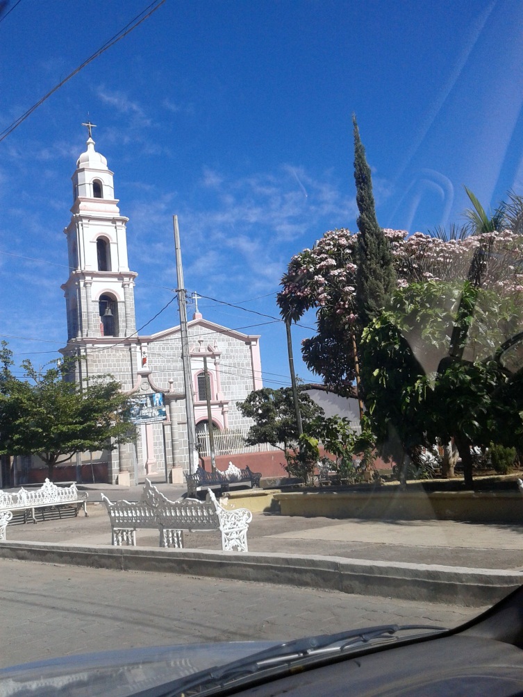
This is hot country: temperatures run from 18 to 36 °C, with about 745 mm of summer rain a year. The town is ringed by orchards of limes, papaya, mango, orange and grapefruit, plus maize, chilli and melon fields, and it has lime-packing plants and a plant that distils essential oil. The parish church is dedicated to the Sacred Heart of Jesus, whose feast falls in June. December brings the municipality's anniversary, the Virgin of Guadalupe and the posadas, and the Feria del Limón follows Christmas. Local cooking runs to morisqueta, fish and grilled meat, and the traditional music is harp, violin and guitar.
On 24 February 2013 La Ruana, in the same municipality, became the first community to take up arms against the Knights Templar cartel; Buenavista Tomatlán joined the self-defence movement a few weeks later.
How to get to Buenavista Tomatlán
From Apatzingán, head west on federal highway 120 (Quiroga–Tepalcatepec), which crosses the valley straight to Buenavista Tomatlán: 30 minutes and 32 km by road, and the same highway continues to Tepalcatepec. The nearest Pueblo Mágico by road is Cotija, 1 h 40 min away (101 km). Bus lines including Parhikuni, Purhépechas, Línea Plus and Transportes Tancítaro link the town with Apatzingán, Uruapan, Morelia, Zamora, Colima and Guadalajara. The UK government advises against all but essential travel to Michoacán except Morelia, Pátzcuaro and their access roads; Buenavista is outside those exceptions, so travel by day and check local conditions before you go.
Directions to Buenavista Tomatlán on Google Maps
Distances are in a straight line; the road is usually longer.
Links open a partner site. We may earn a commission if you book, at no cost to you.
From the nearest cities to Buenavista Tomatlán
- Apatzingán · about 35 km by road, ~30 min
- Uruapan · about 80 km by road, ~1 h 10 min
- Zamora · about 120 km by road, ~1 h 45 min
Drive times by road from OpenStreetMap, without traffic or stops. Times marked ~ are estimated from the straight-line distance.
Before you go to Buenavista Tomatlán: hours, prices and tips
- Best season
- The feast of the Sacred Heart, the patron, is in June; 5 December marks the founding of the municipality, posadas run 16-23 December, and the Feria del Limón comes after Christmas. Wikipedia · checked Oct 2026
- Rules
- The UK advises against all but essential travel to Michoacán, except Morelia, Pátzcuaro and their access roads. GOV.UK · checked Oct 2026
Hours and prices change, especially around holidays. Each fact links to where we checked it.
Visiting Buenavista Tomatlán: what to see and do
See the Sacred Heart parish church and the main square.
Take in the lime orchards around town and the packing plants in the seat.
Come for the December posadas and, after Christmas, the Feria del Limón.
Visit Santa Ana Amatlán, 15 km away, with its Franciscan church of 1612.
Look for the ruins of the Hacienda del Nacimiento and its arched aqueduct in the municipality.
Try morisqueta, the rice-and-beans dish of the Tierra Caliente.
Plan your trip
Places to stay in Buenavista Tomatlán
Compare hotels, posadas, and rentals in and around Buenavista Tomatlán.
Tours & activities
Day trips and guided outings from Cotija often include Buenavista Tomatlán; with a local guide you can get there without a car.
Rental cars
Pick up a car at UPN (Uruapan): about 2 h 5 min by road to Cotija, then 68 km more to Buenavista Tomatlán, on your own schedule.
Flights
The nearest airport with scheduled flights is Uruapan (UPN), about 2 h 5 min by road from Cotija, the base for Buenavista Tomatlán.
Mobile data
Signal can drop away from Cotija: download a map of the way to Buenavista Tomatlán before you set out, or carry an eSIM with data.
Links open a partner site. We may earn a commission if you book, at no cost to you.
When to go to Buenavista Tomatlán mild
Buenavista Tomatlán shares the climate of Cotija, 68 km away. The best months to visit are January, March, April, and November.
See the month-by-month climate of Cotija
Weather in Buenavista Tomatlán now and the next 7 days
Live forecast from Open-Meteo. Chance of rain is the day's highest.
The closest Pueblo Mágico: Cotija

Cotija is the Pueblo Mágico closest to Buenavista Tomatlán, with places to stay, food, and more to see.
Also close to
- Paracho · Michoacán · 75 km away
Closest to Buenavista Tomatlán
-
Tepalcatepec · Town · 27 km away
-
Apatzingán · City · 28 km away
-
Chorros del Varal · Waterfall · 35 km away
-
Parácuaro · Town · 39 km away
-
Volcán Paricutín · Mountain · 47 km away
-
Jilotlán de los Dolores · Village · 49 km away
-
Zacán · Town · 50 km away
Near Buenavista Tomatlán


Drive times by road from OpenStreetMap, without traffic. Times marked ~ are estimated from the straight-line distance.
Location from OpenStreetMap. Written by Puebloteca.