
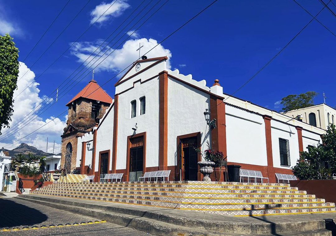
Town Santa María del Oro, Jalisco
Former mining settlement in southeast Jalisco and seat of the state's least populous municipality, with yácatas and the Templo Viejo.
From Sahuayo: 2 h 20 min by car (106 km by road) How to get there ↓
Near here
See everything nearby ↓



Plan your visit to Santa María del Oro
Where to stay near Santa María del Oro
Compare hotels, posadas and guest houses in Santa María del Oro.
Tours to Santa María del Oro
Day trips around Cotija sometimes stop in Santa María del Oro; a tour is the easy way to see it without a car.
How to get to Santa María del Oro
- From Sahuayo: about 2 h 20 min by road (~106 km)
- Nearest airport: Uruapan (UPN), 2 h 5 min by car to Cotija
Links open a partner site. We may earn a commission if you book, at no cost to you.
About Santa María del Oro
Santa María del Oro is the seat of a municipality in southeast Jalisco, beside the Michoacán border. At the 2020 census the town had 666 residents and the whole municipality only 1,815, making it the least populous in the state. The name comes from its mining past: before the conquest the region belonged to the Purépecha, defeated in the Saltpetre War of 1510, and in 1523 Alonso de Ávalos subdued the peoples of the area.
According to the official historical account, the site began as a ranch called La Teja and, from the mid-18th century, became the Real Hacienda de Beneficio del Río del Oro. More than twenty mines were being worked, and the Real del Oro had furnaces where silver and gold ore was refined; the bars left in caravans for Mexico City. North of the town the La Jarana sugar mill also ran. In 1812 insurgent forces under Francisco Guzmán surprised and beheaded 42 Spaniards on the spot now occupied by the parish church. At the Las Minas ranch, 6 km to the east, yácatas and ruins mark the oldest workings.
The settlement of Santa María de Guadalupe became a municipality in 1938 under the name Manuel M. Diéguez, honouring the revolutionary and governor; the name Santa María del Oro was restored for the town in 1997 and for the municipality in 1999. Surviving architecture includes the Templo Viejo, and the surroundings take in the forests of Cerro El Encamizado, La Mesa del Valle and Las Águilas, the landscapes of Las Bufas and Llanos de Zipoco, and three hot springs in the municipality.
The feast of the Virgin of Guadalupe is held here in January rather than December: the priests of the old chaplaincy could not serve two towns at once, so the dates were shifted a month. Local dishes include goat birria, pozole, briado and tejuino; the typical craft is huaraches.
How to get to Santa María del Oro
Drive from Sahuayo: 2 h 20 min, 106 km
Santa María del Oro is in southeast Jalisco, bordered by Quitupan to the north, Jilotlán de los Dolores to the south, Tamazula de Gordiano to the west and the state of Michoacán to the east. From Zapopan, yotellevo.mx estimates about 209 km by car (roughly 3 h 45 min), and from Ciudad Guzmán another route site gives about 177 km by road (roughly 3 h 30 min); in a straight line Cotija, Michoacán, is about 33 km away. Access is by roads through the Quitupan and Tamazula area, with mountain stretches. There are no published bus schedules for the town; the Enciclopedia de los Municipios notes that tourist infrastructure amounts to one guesthouse and a few fondas, so allow generous time and confirm transport in Tamazula or Quitupan. To Ciudad Guzmán it is about 59 km in a straight line.
Directions to Santa María del Oro on Google Maps
Distances are in a straight line; the road is usually longer.
Links open a partner site. We may earn a commission if you book, at no cost to you.
From the nearest cities to Santa María del Oro
- Sahuayo · 106 km by road, 2 h 20 min
- Zamora · 157 km by road, 3 h 5 min
- Ciudad Guzmán · 162 km by road, 3 h 10 min
Drive times by road from OpenStreetMap, without traffic or stops. Times marked ~ are estimated from the straight-line distance.
Before you go to Santa María del Oro: hours, prices and tips
- Best season
- Feast of the Virgin of Guadalupe 3 to 12 January (not December); Independence Day 16 September. Enciclopedia de los Municipios de México (INAFED) · checked Oct 2026
Hours and prices change, especially around holidays. Each fact links to where we checked it.
Visiting Santa María del Oro: what to see and do
Templo Viejo, the town's old church.
The parish church, on the site where 42 Spaniards were beheaded in 1812.
Las Minas ranch, 6 km east, with yácatas and ruins of the early mines.
Forests of Cerro El Encamizado, La Mesa del Valle and Las Águilas.
Las Bufas and Llanos de Zipoco: landscapes and rock formations in the municipality.
Feast of the Virgin of Guadalupe, 3 to 12 January.
Plan your trip
Places to stay in Santa María del Oro
Compare hotels, posadas, and rentals in and around Santa María del Oro.
Tours & activities
Day trips around Cotija sometimes stop in Santa María del Oro; a tour is the easy way to see it without a car.
Rental cars
Pick up a car at UPN (Uruapan): about 2 h 5 min by road to Cotija, then 33 km more to Santa María del Oro, on your own schedule.
Flights
The nearest airport with scheduled flights is Uruapan (UPN), about 2 h 5 min by road from Cotija, the base for Santa María del Oro.
Mobile data
Signal can drop away from Cotija: download a map of the way to Santa María del Oro before you set out, or carry an eSIM with data.
Links open a partner site. We may earn a commission if you book, at no cost to you.
When to go to Santa María del Oro mild
Santa María del Oro shares the climate of Cotija, 33 km away. The best months to visit are January, March, April, and November.
See the month-by-month climate of Cotija
Weather in Santa María del Oro now and the next 7 days
Live forecast from Open-Meteo. Chance of rain is the day's highest.
The closest Pueblo Mágico: Cotija

Cotija is the Pueblo Mágico closest to Santa María del Oro, with places to stay, food, and more to see.
Also close to
Closest to Santa María del Oro
-
Jilotlán de los Dolores · Village · 27 km away
-
La Garita · Village · 31 km away
-
Cerro del Tigre · Viewpoint · 36 km away
-
Cascada El Salto · Waterfall · 37 km away
-
Chorros del Varal · Waterfall · 37 km away
-
Tamazula de Gordiano · Town · 37 km away
-
Quitupan · Village · 38 km away
-
Valle de Juárez · Town · 39 km away


Near Santa María del Oro


Drive times by road from OpenStreetMap, without traffic. Times marked ~ are estimated from the straight-line distance.
Location from OpenStreetMap. Written by Puebloteca.