

Town Pátzcuaro, Michoacán Municipality of Pátzcuaro Lake Pátzcuaro
A small, green and quiet island in the north of the lake, a calmer alternative to Janitzio by boat from Pátzcuaro.
Reached by boat from Muelle General, Pátzcuaro: 25 min each way. How to get there ↓
Near here


Plan your visit to Isla Yunuén
Tours to Isla Yunuén
Day trips around Tzintzuntzan sometimes stop in Isla Yunuén; a tour is the easy way to see it without a car.
 Tours from Morelia
Morelia City Tour
★ 4.9 (115) · From US$33
How to get to Isla Yunuén
- Reached by boat from Muelle General, Pátzcuaro: 25 min each way.
- From Pátzcuaro: about 5 min by road (~4 km)
- 8 km southwest of Tzintzuntzan
- Nearest airport: Uruapan (UPN), 57 min by car to Tzintzuntzan
Links open a partner site. We may earn a commission if you book, at no cost to you.
Tours from Morelia, near Isla Yunuén


Tours, prices and ratings from Viator, checked weekly. We may earn a commission if you book.
About Isla Yunuén
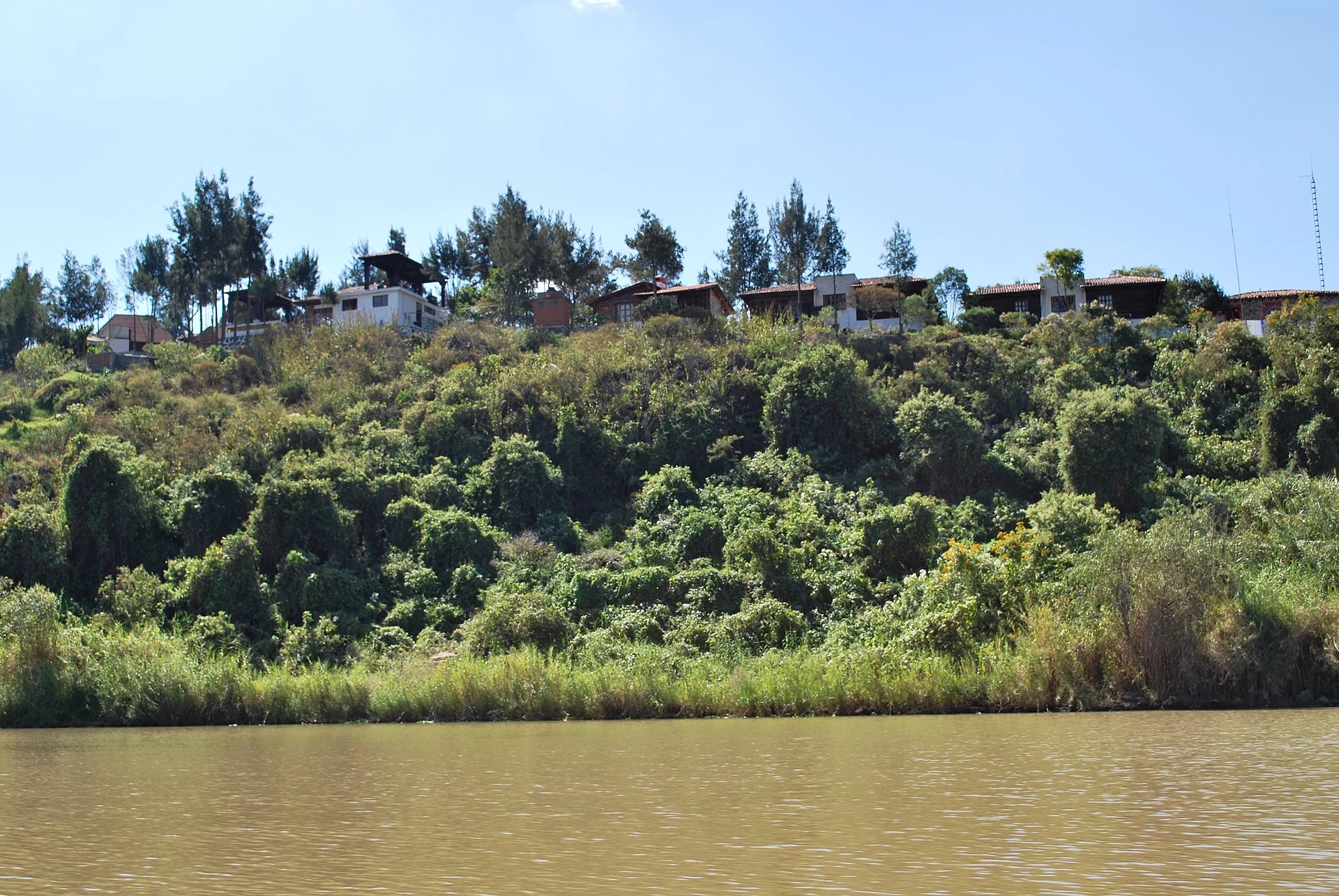
Yunuén is one of the small islands in the middle of Lake Pátzcuaro, a curved strip of land only about 200 meters long whose Purépecha name refers to its bent, crooked shape. While Janitzio fills with souvenir stalls and day-trippers, Yunuén stays green and quiet, covered with pines, oaks and cedars, with herons nesting on its shores and a handful of Purépecha families who fish and farm.
The islanders formed a cooperative to run a small ecotourism center, with rustic wooden cabins, a restaurant serving lake fish and regional dishes, paths around the island and lookouts over the water toward Janitzio and the shore. A zip line links Yunuén with neighboring La Pacanda, one of the more unusual ways to cross part of the lake.
The island has its own legend, of a princess called Hapunda who threw herself into the lake rather than be married off and came back as a heron, and its own Day of the Dead vigil on the nights of November 1 and 2. For most visitors, though, the appeal is simpler: a night or a long afternoon on an island with no traffic and very little noise.
How to get to Isla Yunuén
Drive from Pátzcuaro to Muelle General, Pátzcuaro: 5 min, 4 km
Boats to Yunuén leave from Pátzcuaro's main pier (Muelle General) and from the San Pedrito pier; the crossing takes roughly 20 to 30 minutes. From Tzintzuntzan, drive about 20 minutes to Pátzcuaro's piers. Arrange your return trip with the boatman, or book the cabins ahead to include transport.
Reached by boat from Muelle General, Pátzcuaro: 25 min each way.
8 km southwest of Tzintzuntzan
Directions from Tzintzuntzan on Google Maps
Distances are in a straight line; the road is usually longer.
Links open a partner site. We may earn a commission if you book, at no cost to you.
From the nearest cities to Isla Yunuén
- Pátzcuaro · 4 km by road, 5 min to Muelle General, Pátzcuaro, then 25 min by boat
- Morelia · 55 km by road, 45 min to Muelle General, Pátzcuaro, then 25 min by boat
- Uruapan · 56 km by road, 45 min to Muelle General, Pátzcuaro, then 25 min by boat
Drive times by road from OpenStreetMap, without traffic or stops. Times marked ~ are estimated from the straight-line distance.
What to see in Isla Yunuén 1
Sights with their own page, closest to the centre first.
-
Zona Arqueológica de Ihuatzio · Archaeological site · 4 km from the centre
One of the three Purépecha capitals: rectangular pyramids and raised stone causeways on a hill above the lake.
Map of Isla Yunuén
Neighbourhoods and villages of Isla Yunuén
Part of Isla Yunuén or just outside it, closest first.
-
Isla Yunuén · Town · in the centre
A small, green and quiet island in the north of the lake, a calmer alternative to Janitzio by boat from Pátzcuaro. -
Isla La Pacanda · Town · 1 km from the centre
A round, farming island in the middle of the lake with an inner lagoon and a famous Day of the Dead, with altars open in homes. -
Isla de Janitzio · Town · 3 km from the centre
The lake's best-known island, crowned by a giant Morelos statue you can climb inside, a short boat ride from Pátzcuaro's pier.

Day trips and tours from Isla Yunuén
The closest Pueblos Mágicos and places to visit, with the drive from Isla Yunuén and tours that leave from it.


Times marked ~ are estimated from the distance. Links open a partner site. We may earn a commission if you book, at no cost to you.
Before you go: getting to and around Isla Yunuén
- The nearest airport is Uruapan (UPN).
- The best months to go are January, February, March, and April.
- 1 of the places on this page is more than 3 km from the centre: take a taxi, a ride-hailing app or a local bus.
- Isla Yunuén, Isla La Pacanda, and Isla de Janitzio: reached by boat or on foot, not by road (each page says from where).
- For day trips a rental car gives the most freedom; the tours above leave from Isla Yunuén.
Before you go to Isla Yunuén: hours, prices and tips
- Time needed
- A walk around the whole island takes 20–30 minutes; many visitors stay overnight in the community's wooden cabins. Food and Pleasure · checked Oct 2026
- Guide or tour
- Reached by boat from Pátzcuaro's Muelle General or San Pedrito pier, a 20–30 minute ride. A 550 m zip line links the island with La Pacanda. Tours: Viator GetYourGuide Food and Pleasure · checked Oct 2026
Hours and prices change, especially around holidays. Each fact links to where we checked it.
Visiting Isla Yunuén: what to see and do
Walk the paths around the island and watch the herons along the shore.
Stay a night in the cooperative's wooden cabins.
Eat white fish or other lake fish at the island restaurant.
Ride the zip line over to neighboring La Pacanda.
Plan your trip
Places to stay in Isla Yunuén
Hotel Boutique Hacienda Ucazanaztacua Hotel · 1.8 km from the center Find on Expedia Hotel San Carlos Hotel · 7.2 km from the center Find on Expedia Estrella Hotel · 7.3 km from the center Find on Expedia Hotel Colibri 250 mxn Hotel · 7.3 km from the center Find on Expedia Hotel Colibri Hotel · 7.3 km from the center Find on Expedia Hotel Chalamú Hotel · 7.7 km from the center Find on ExpediaTours & activities
Day trips around Tzintzuntzan sometimes stop in Isla Yunuén; a tour is the easy way to see it without a car.
Rental cars
Pick up a car at UPN (Uruapan): about 57 min by road to Tzintzuntzan, then 8 km more to Isla Yunuén, on your own schedule.
Flights
The nearest airport with scheduled flights is Uruapan (UPN), about 57 min by road from Tzintzuntzan, the base for Isla Yunuén.
Mobile data
Signal can drop away from Tzintzuntzan: download a map of the way to Isla Yunuén before you set out, or carry an eSIM with data.
Links open a partner site. We may earn a commission if you book, at no cost to you. Hotel names from OpenStreetMap.
Photos
When to go to Isla Yunuén mild
Isla Yunuén shares the climate of Tzintzuntzan, 8 km away. The best months to visit are January, February, March, and April.
See the month-by-month climate of Tzintzuntzan
Weather in Isla Yunuén now and the next 7 days
Live forecast from Open-Meteo. Chance of rain is the day's highest.
Make Tzintzuntzan your base

Isla Yunuén is an easy trip from Tzintzuntzan, a Pueblo Mágico with places to stay, food, and more to see.
Also close to
- Pátzcuaro · Michoacán · 10 km away
- Santa Clara del Cobre · Michoacán · 22 km away
- Paracho · Michoacán · 42 km away
- Tacámbaro · Michoacán · 45 km away
- Cuitzeo · Michoacán · 67 km away
Near Isla Yunuén
-
Erongarícuaro · Town · Michoacán
45 min: 25 min by boat back to Muelle General, Pátzcuaro, then drive -
Santa Fe de la Laguna · Town · Michoacán
50 min: 25 min by boat back to Muelle General, Pátzcuaro, then drive -
San Jerónimo Purenchécuaro · Town · Michoacán
1 h: 25 min by boat back to Muelle General, Pátzcuaro, then drive -
Zona Arqueológica de Tingambato · Archaeological site · Michoacán
1 h: 25 min by boat back to Muelle General, Pátzcuaro, then drive -
Museo y Archivo Histórico Casa de Morelos · Landmark · Michoacán
1 h 10 min: 25 min by boat back to Muelle General, Pátzcuaro, then drive -
Museo Casa Natal de Morelos · Landmark · Michoacán
1 h 10 min: 25 min by boat back to Muelle General, Pátzcuaro, then drive -
Museo Regional Michoacano · Landmark · Michoacán
1 h 10 min: 25 min by boat back to Muelle General, Pátzcuaro, then drive


Drive times by road from OpenStreetMap, without traffic. Times marked ~ are estimated from the straight-line distance.
Something wrong or missing on this page? Suggest a fix or addition
Location from OpenStreetMap. Written by Puebloteca.