
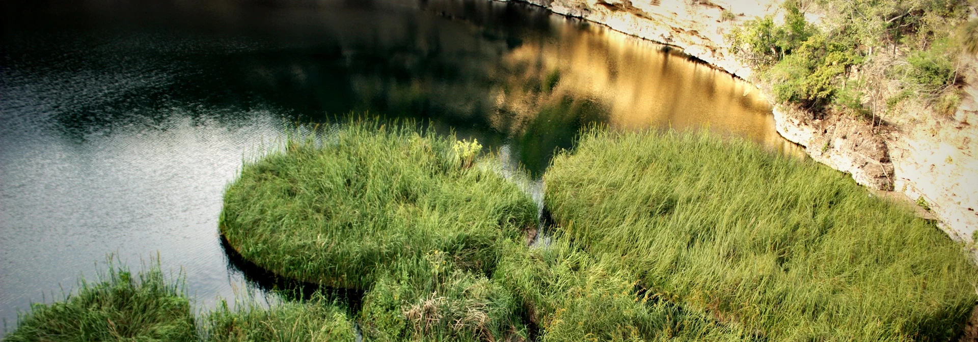
Cenote Aldama, Tamaulipas
One of the deepest water-filled sinkholes on Earth, 339 m, with floating grass islands that drift in the wind, on La Azufrosa ranch in Aldama.
From Ciudad Mante: 1 h 55 min by car (118 km by road) How to get there ↓
Plan your visit to El Zacatón
Where to stay near El Zacatón
Compare hotels, posadas and guest houses in El Zacatón.
Tours to El Zacatón
Day trips and guided outings from Tamaulipas often include El Zacatón; with a local guide you can get there without a car.
How to get to El Zacatón
- From Ciudad Mante: about 1 h 55 min by road (~118 km)
Links open a partner site. We may earn a commission if you book, at no cost to you.
About El Zacatón
El Zacatón is a thermal water-filled sinkhole on La Azufrosa ranch in the municipality of Aldama, at the foot of the Sierra de Tamaulipas. From the rim it looks like a round crater with rock walls and a dark green pool at the bottom, across which islands of zacate grass drift as the wind pushes them; they give the place its name. What you cannot see is the depth. It is about 20 metres from the cliff edge down to the water, and below the surface an autonomous robot measured another 319 metres, for a total of 339. That puts it among the deepest flooded sinkholes known anywhere.
It belongs to the Zacatón System, a group of five connected cenotes at La Azufrosa (El Zacatón, La Poza Verde, El Caracol, La Pilita and La Azufrosa), and it is the only one of them with noticeable water flow. The area has more than fifteen sinkholes, caves and karst springs, some capped by travertine crusts that are slowly sealing them from the top; one, Poza Seca, has closed completely over an isolated underground lake. Hydrogeologist Marcus Gary, who has studied the system since the late 1990s, argues that these shafts formed differently from other caves in the region: in the Pleistocene, volcanic activity deep below charged the groundwater with carbon dioxide and hydrogen sulphide, which dissolved the limestone from beneath until the roof collapsed into vertical shafts.
El Zacatón has a place in deep-diving history. In 1993 Ann Kristovich set the women's depth record here at 169 metres, and on 6 April 1994 Jim Bowden reached 282 metres, then the men's record, on the same dive in which cave-diving pioneer Sheck Exley died at around 270 metres, probably from high-pressure nervous syndrome. Later NASA's DEPTHX project, built by Stone Aerospace with several US universities, used the sinkhole to test a robot designed to explore Jupiter's moon Europa; its samples turned up about a hundred microbes, including at least three entirely new groups of bacteria.
Today diving is limited to scientific work and highly experienced divers because of the depth and the sulphur in the water. Visitors come to look down from the rim, walk the surroundings and combine it with the other cenotes: La Poza Verde, about 150 metres across and 45 deep, is good for swimming, snorkelling and kayaking, and La Pilita has warm springs. The Los Cuarteles caves are nearby.
How to get to El Zacatón
Drive from Ciudad Mante: 1 h 55 min, 118 km
From Tampico it is about 125 km, around 2 hours: head north on federal highway 80 to Altamira and take highway 180 toward Aldama. From the town of Aldama a rural road of about 18 km runs northwest to La Azufrosa ranch; a suitable vehicle helps, and it is worth asking in town about the road. From Ciudad Victoria it is about 2 hours: drive toward Tampico and turn off for Aldama at Estación Manuel. There is no public transport to the cenotes. The nearest Pueblos Mágicos, Aquismón and Tula, are about 3.5 hours away.
Directions to El Zacatón on Google Maps
Distances are in a straight line; the road is usually longer.
Links open a partner site. We may earn a commission if you book, at no cost to you.
From the nearest cities to El Zacatón
- Ciudad Mante · 118 km by road, 1 h 55 min
- Tampico · 130 km by road, 2 h
- Ciudad Valles · about 185 km by road, ~2 h 40 min
Drive times by road from OpenStreetMap, without traffic or stops. Times marked ~ are estimated from the straight-line distance.
Before you go to El Zacatón: hours, prices and tips
- Entry
- Entry is around 60 pesos per person; the money goes to looking after the site. POSTA México · checked Oct 2026
- What to bring
- Swimsuit, proper footwear, a life jacket if you cannot swim, and biodegradable sunscreen. POSTA México · checked Oct 2026
- Rules
- Diving in El Zacatón is restricted to scientific research and highly experienced divers because of its depth and high sulphur content. POSTA México · checked Oct 2026
Hours and prices change, especially around holidays. Each fact links to where we checked it.
Visiting El Zacatón: what to see and do
Look down into the shaft from the rim and spot the grass islands floating on the water.
Swim, snorkel or kayak in La Poza Verde, the neighbouring cenote.
See the warm springs of La Pilita and the pools of El Caracol and La Azufrosa.
Explore the Los Cuarteles caves, a short way from the cenotes.
On the cenote route, start at El Nacimiento, where the Río Blanco rises.
Plan your trip
Places to stay in El Zacatón
Compare hotels, posadas, and rentals in and around El Zacatón.
Tours & activities
Day trips and guided outings from Tamaulipas often include El Zacatón; with a local guide you can get there without a car.
Travel insurance
If you plan on swimming or snorkeling at El Zacatón, check that your policy covers it: some plans leave adventure activities out.
Mobile data
Signal can drop away from Tamaulipas: download a map of the way to El Zacatón before you set out, or carry an eSIM with data.
Links open a partner site. We may earn a commission if you book, at no cost to you.
Near El Zacatón




Drive times by road from OpenStreetMap, without traffic. Times marked ~ are estimated from the straight-line distance.
Location from OpenStreetMap. Written by Puebloteca.