



Village Mérida, Yucatán Municipality of Mérida Mérida and around
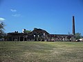
A village at the southern end of Mérida municipality, set around the large ruined house, machine hall and tall chimney of its henequen hacienda.
From Mérida: 35 min by car (29 km by road) How to get there ↓
Near here
See everything nearby ↓


Plan your visit to San Antonio Tzacalá
Where to stay near San Antonio Tzacalá
Compare hotels, posadas and guest houses in San Antonio Tzacalá.
Tours to San Antonio Tzacalá
Day trips and guided outings from Maní often include San Antonio Tzacalá; with a local guide you can get there without a car.
 Tours from Merida
From Merida: Chichen Itza Tour, Izamal, Cenote Ik Kil and Food
★ 4.9 (578) · From US$74
How to get to San Antonio Tzacalá
- From Mérida: about 35 min by road (~29 km)
- Nearest airport: Mérida (MID), 1 h 27 min by car to Maní
Links open a partner site. We may earn a commission if you book, at no cost to you.
Tours from Merida, near San Antonio Tzacalá


Tours, prices and ratings from Viator, checked weekly. We may earn a commission if you book.
About San Antonio Tzacalá
San Antonio Tzacalá, usually just Tzacalá, is a comisaría of Mérida municipality about 28 km south of the city centre. Petac lies to its north. The village had 715 inhabitants in the 2020 census. Its name joins Saint Anthony of Padua, the patron, with the Maya Tzacalá, read as "wheel woven of vine and basil".
Tzacalá grew around a henequen hacienda whose large buildings still stand, though in ruins. The main house stands on a raised platform reached by a broad flight of steps, with a portico of slender columns across its front; inside, traces of painted decoration with stencilled flowers and borders survive on the walls. Across a wide open green rise the long, arched walls of the machine house and a tall brick chimney, and a crumbling stone gateway stands by the road. Photographs from 2012 show the buildings abandoned and partly roofless.
The village itself is small, with a yellow-and-red casa comisarial, a small church with a pointed gable beside the hacienda walls, two parks, a kindergarten, a primary school, a telesecundaria and a cemetery. For anyone interested in Yucatán's henequen history, the hacienda ruins can be seen from the village streets; they make a good stop on a drive through the hacienda villages south of Mérida, together with Texán Cámara, Yaxnic and Dzoyaxché.
How to get to San Antonio Tzacalá
Drive from Mérida: 35 min, 29 km
Tzacalá is about 28 km south of central Mérida. Leave the city to the south through San José Tzal and continue past Petac; allow about 40 minutes by car and use a map app for the local roads.
Directions to San Antonio Tzacalá on Google Maps
Distances are in a straight line; the road is usually longer.
Links open a partner site. We may earn a commission if you book, at no cost to you.
From the nearest cities to San Antonio Tzacalá
- Mérida · 29 km by road, 35 min
- Campeche · 158 km by road, 2 h 20 min
- Valladolid · 185 km by road, 2 h 35 min
Drive times by road from OpenStreetMap, without traffic or stops. Times marked ~ are estimated from the straight-line distance.
Visiting San Antonio Tzacalá: what to see and do
See the ruined main house of the hacienda, with its broad steps and columned portico.
Look at the machine house and its tall brick chimney across the green.
Find the crumbling stone gateway by the road.
Visit the small village church beside the hacienda walls.
Plan your trip
Places to stay in San Antonio Tzacalá
Compare hotels, posadas, and rentals in and around San Antonio Tzacalá.
Tours & activities
Day trips and guided outings from Maní often include San Antonio Tzacalá; with a local guide you can get there without a car.
Rental cars
Pick up a car at MID (Mérida): about 1 h 27 min by road to Maní, then 49 km more to San Antonio Tzacalá, on your own schedule.
Flights
The nearest airport with scheduled flights is Mérida (MID), about 1 h 27 min by road from Maní, the base for San Antonio Tzacalá.
Mobile data
Signal can drop away from Maní: download a map of the way to San Antonio Tzacalá before you set out, or carry an eSIM with data.
Links open a partner site. We may earn a commission if you book, at no cost to you.
Photos
When to go to San Antonio Tzacalá warm
San Antonio Tzacalá shares the climate of Maní, 49 km away. The best months to visit are January, February, November, and December.
See the month-by-month climate of Maní
Weather in San Antonio Tzacalá now and the next 7 days
Live forecast from Open-Meteo. Chance of rain is the day's highest.
The closest Pueblo Mágico: Maní

Maní is the Pueblo Mágico closest to San Antonio Tzacalá, with places to stay, food, and more to see.
Also close to
Closest to San Antonio Tzacalá
-
Petac · Village · 2 km away
-
Texán Cámara · Village · 5 km away
-
Yaxnic · Village · 5 km away
-
Hacienda Temozón Sur · Landmark · 7 km away
-
Hacienda Yaxcopoil · Landmark · 7 km away
-
Hotzuc · Village · 7 km away
-
Dzoyaxché · Village · 8 km away
-
Hacienda Sotuta de Peón · Landmark · 8 km away


Near San Antonio Tzacalá


Drive times by road from OpenStreetMap, without traffic. Times marked ~ are estimated from the straight-line distance.
Location from OpenStreetMap. Written by Puebloteca.