

Town Zihuatanejo de Azueta, Guerrero Municipality of Zihuatanejo de Azueta Costa Grande of Guerrero
Zihuatanejo's planned resort twin: a long hotel beach, a marina, bike paths through mangroves, and boats to Isla Ixtapa.
From Zihuatanejo: 10 min by car (9 km by road) How to get there ↓
Near here
See everything nearby ↓


Plan your visit to Ixtapa
Tours to Ixtapa
Day trips around Zihuatanejo sometimes stop in Ixtapa; a tour is the easy way to see it without a car.
 Private Ixtapa and Zihuatanejo City Tour
★ 5.0 (153) · From US$56
How to get to Ixtapa
- From Zihuatanejo: about 10 min by road (~9 km)
- 6 km west of Zihuatanejo
- Nearest airport: Zihuatanejo (ZIH), 12 min by car to Zihuatanejo
Links open a partner site. We may earn a commission if you book, at no cost to you.
Popular tours to Ixtapa


Tours, prices and ratings from Viator, checked weekly. We may earn a commission if you book.
About Ixtapa
Ixtapa sits just five kilometers northwest of Zihuatanejo, but the two could hardly be more different. Where Zihuatanejo grew as a fishing village around its bay, Ixtapa was drawn up on paper. In the late 1960s the Bank of Mexico set up a fund to build new beach destinations from scratch, and Ixtapa was one of the first two, alongside Cancún. It was built in the early 1970s on what had been a coconut plantation and mangrove estuary, with a master plan by the architects Agustín and Enrique Landa Verdugo.
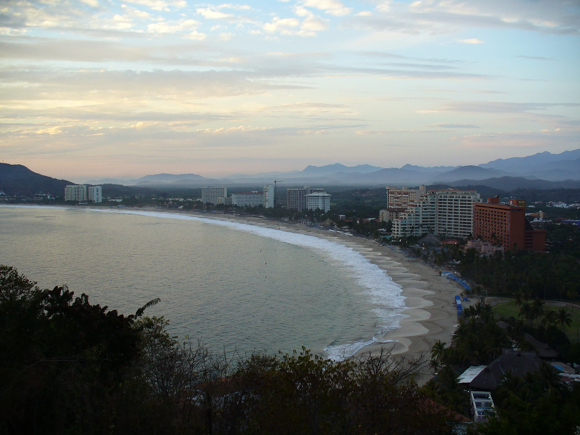
The result is a tidy resort town of wide boulevards, large hotels lined up along Playa El Palmar, a marina with restaurants and a golf course, and shopping plazas. It is the place to go from Zihuatanejo for a long open beach, water sports, or a sunset drink on the marina.
Ixtapa's best surprise is how green it is between the buildings. Flat, shaded bike paths run through the mangroves and wetlands to Playa Linda at the north end, where crocodiles often sun themselves along the ponds, and another path links Ixtapa with Zihuatanejo. Playa Linda is also where the boats leave for Isla Ixtapa.
How to get to Ixtapa
Drive from Zihuatanejo: 10 min, 9 km
Ixtapa is about 10 to 15 minutes from downtown Zihuatanejo by car or taxi along the boulevard that links the two. Local buses run between Zihuatanejo and Ixtapa throughout the day, and a dedicated bike path connects them too, about 10 km one way.
6 km west of Zihuatanejo
Directions from Zihuatanejo on Google Maps
Distances are in a straight line; the road is usually longer.
Links open a partner site. We may earn a commission if you book, at no cost to you.
From the nearest cities to Ixtapa
- Zihuatanejo · 9 km by road, 10 min
- Lázaro Cárdenas · 94 km by road, 1 h 10 min
- Apatzingán · 224 km by road, 2 h 50 min
Drive times by road from OpenStreetMap, without traffic or stops. Times marked ~ are estimated from the straight-line distance.
Before you go to Ixtapa: hours, prices and tips
- Best season
- Official whale-watching season is December 15 to March 20. Ixtapa Zihuatanejo tourism office · checked Oct 2026
- Guide or tour
- You get around on your own. For Isla Ixtapa, take a boat from the pier at Playa Linda; whale tours (2 to 3 hours) leave with certified operators, some booked through Ixtapa hotels. Ixtapa Zihuatanejo tourism office · checked Oct 2026
- Rules
- Playa Linda sits next to an estuary with river crocodiles: respect the fences and warning signs and stay out of the fenced-off areas. Luz Noticias · checked Oct 2026
Hours and prices change, especially around holidays. Each fact links to where we checked it.
Visiting Ixtapa: what to see and do
Rent a bike and ride the shaded path through the mangroves to Playa Linda, watching for crocodiles in the ponds.
Spend a day on Playa El Palmar, the long beach in front of the hotels; the surf can be strong, so check the flags before swimming.
Walk the Marina Ixtapa docks and stay for dinner at one of its restaurants.
Take a boat from Playa Linda to Isla Ixtapa for snorkeling and seafood.
Plan your trip
Places to stay in Ixtapa
Hotel Fontán Ixtapa Hotel · ★★★★ · 290 m from the center Find on Expedia Krystal Ixtapa Hotel · ★★★★ · 510 m from the center Find on Expedia Villas Paraiso Ixtapa Hotel · 250 m from the center Find on Expedia Holiday Inn Resort Ixtapa Hotel · 260 m from the center Find on Expedia Sunscape Hotel · 290 m from the center Find on Expedia Emporio Ixtapa Hotel · 300 m from the center Find on ExpediaTours & activities
Day trips around Zihuatanejo sometimes stop in Ixtapa; a tour is the easy way to see it without a car.
Rental cars
Pick up a car at ZIH (Zihuatanejo): about 12 min by road to Zihuatanejo, then 6 km more to Ixtapa, on your own schedule.
Flights
The nearest airport with scheduled flights is Zihuatanejo (ZIH), about 12 min by road from Zihuatanejo, the base for Ixtapa.
Mobile data
Signal can drop away from Zihuatanejo: download a map of the way to Ixtapa before you set out, or carry an eSIM with data.
Links open a partner site. We may earn a commission if you book, at no cost to you. Hotel names from OpenStreetMap.
Photos
When to go to Ixtapa warm
Ixtapa shares the climate of Zihuatanejo, 6 km away. The best months to visit are January, February, March, and April.
See the month-by-month climate of Zihuatanejo
Weather in Ixtapa now and the next 7 days
Live forecast from Open-Meteo. Chance of rain is the day's highest.
Make Zihuatanejo your base

Ixtapa is an easy trip from Zihuatanejo, a Pueblo Mágico with places to stay, food, and more to see.
Closest to Ixtapa
-
Playa El Palmar · Beach · 1 km away · Guerrero
-
Museo Arqueológico de la Costa Grande · Landmark · 5 km away · Guerrero
-
Playa Principal and the Paseo del Pescador · Beach · 5 km away · Guerrero
-
Playa Quieta · Beach · 5 km away · Guerrero
-
Isla Ixtapa · Nature reserve · 6 km away
-
Playa La Madera · Beach · 6 km away · Guerrero
-
Playa Linda · Beach · 6 km away · Guerrero
-
Playa La Ropa · Beach · 7 km away · Guerrero


Near Ixtapa
-
Zihuatanejo · City
10 min drive · 9 km -
Playa Las Gatas · Beach · Guerrero
20 min: drive to Muelle Municipal, Zihuatanejo, then 10 min by boat


Drive times by road from OpenStreetMap, without traffic. Times marked ~ are estimated from the straight-line distance.
Something wrong or missing on this page? Suggest a fix or addition
Location from OpenStreetMap. Written by Puebloteca.