
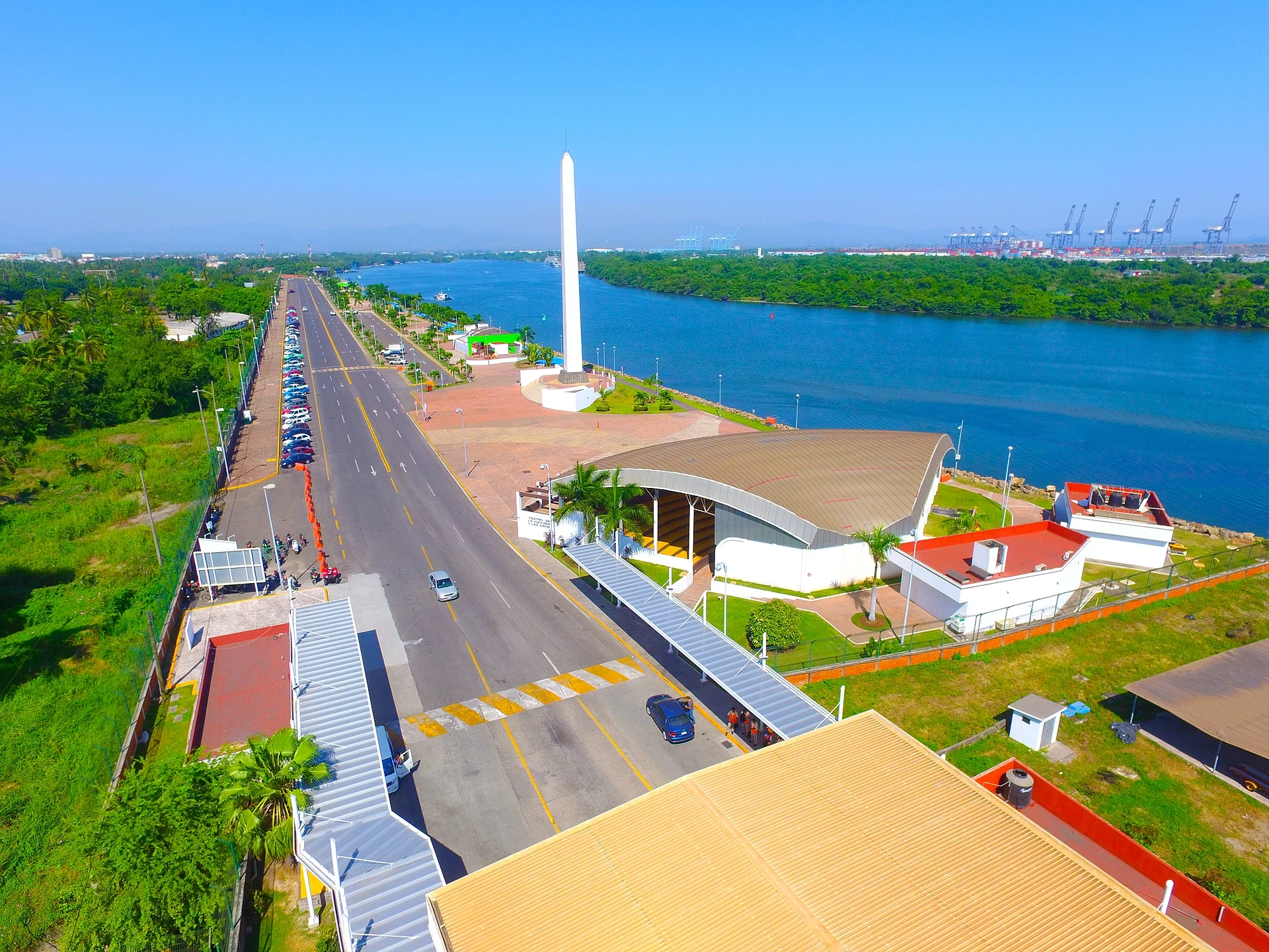


City Lázaro Cárdenas, Michoacán Municipality of Lázaro Cárdenas Michoacán coast
Mexico's biggest seaport, on the Balsas delta at the Guerrero border: a young industrial city with a riverside malecón, gateway to Michoacán's beaches.
From Zihuatanejo: 1 h 10 min by car (97 km by road) How to get there ↓
Plan your visit to Lázaro Cárdenas
Where to stay near Lázaro Cárdenas
Compare hotels, posadas and guest houses in Lázaro Cárdenas.
Tours to Lázaro Cárdenas
Day trips and guided outings from Zihuatanejo often include Lázaro Cárdenas; with a local guide you can get there without a car.
 Tours from Ixtapa
Private Transportation from the Zihuatanejo Airport to your hotel in Ixtapa
★ 4.8 (102) · From US$88
How to get to Lázaro Cárdenas
- From Zihuatanejo: about 1 h 10 min by road (~97 km)
- Nearest airport: Zihuatanejo (ZIH), 12 min by car to Zihuatanejo
Links open a partner site. We may earn a commission if you book, at no cost to you.
Tours from Ixtapa, near Lázaro Cárdenas


Tours, prices and ratings from Viator, checked weekly. We may earn a commission if you book.
About Lázaro Cárdenas
Lázaro Cárdenas is a port city of about 84,000 people (2020) at the southern tip of Michoacán, where the Balsas river, the border with Guerrero, flows into the Pacific. It has grown together with Las Guacamayas and La Orilla into an urban area of nearly 200,000, the fourth largest in the state. The place was long a farming settlement called Los Llanitos, part of Arteaga; it became the tenencia of Melchor Ocampo in 1932, later a municipality, and on 17 November 1970, a month after the death of former president Lázaro Cárdenas del Río, the town and municipality took his name. History here goes further back than the port: in 1523 the Spanish founded the Villa de Concepción de Zacatula at the mouth of the Balsas, and on Hernán Cortés's orders built there the first shipyard on Mexican soil.
The modern city is a product of the 1970s, when the federal government chose the Balsas delta for a deep-water port and a steelworks fed by the iron deposits of Las Truchas, as the spearhead of a plan to industrialise the coast. Today the Port of Lázaro Cárdenas is the largest seaport in Mexico, handling containers, bulk minerals, fluids and car exports, with the only access channel in the country dredged to 18 m and a rail line running to Kansas City. The ArcelorMittal plant is described as the largest steelworks in Latin America. This is a working city rather than a resort, and the town centre is modern, with the white Cathedral of Cristo Rey, seat of the diocese, and the Casa de la Cultura José Vasconcelos, founded in 1979.
For visitors, Lázaro Cárdenas is mainly the gateway and supply base for the Michoacán coast: it has the hotels, restaurants, bus terminals, ATMs and reliable petrol stations that the beaches to the north-west lack. You can walk the broad malecón along the river channel, with views of the port cranes, take a boat trip through the estuaries to look for crocodiles, or drive the 14 km coastal boulevard that runs from Playa Eréndira, about 5 km from the centre, past the sea and the wetlands to Playa Azul. The climate is hot all year, averaging about 26 °C, with rain in summer.
How to get to Lázaro Cárdenas
Drive from Zihuatanejo: 1 h 10 min, 97 km
Lázaro Cárdenas has a national airport at Las Guacamayas, on the edge of the city, with a 2,100 m runway. By road, the Autopista Siglo XXI toll road runs from Morelia via Uruapan to the coast, and the coastal Federal Highway 200 links the city with Colima to the north-west and Zihuatanejo in Guerrero to the south-east. Bus lines such as Autovías and Parhikuni run from Morelia, Uruapan and Mexico City, and local colectivos connect the city with nearby towns. The US State Department rates Michoacán at Level 4, 'Do not travel'; its staff may visit Lázaro Cárdenas only by air and must stay in the city centre and port areas.
Directions to Lázaro Cárdenas on Google Maps
Distances are in a straight line; the road is usually longer.
Links open a partner site. We may earn a commission if you book, at no cost to you.
From the nearest cities to Lázaro Cárdenas
- Zihuatanejo · 97 km by road, 1 h 10 min
- Apatzingán · 193 km by road, 2 h 20 min
- Uruapan · 232 km by road, 2 h 40 min
Drive times by road from OpenStreetMap, without traffic or stops. Times marked ~ are estimated from the straight-line distance.
Before you go to Lázaro Cárdenas: hours, prices and tips
- Best time of day
- Hot all year, averaging about 26 °C, with around 1,280 mm of rain a year, falling mostly in summer. Wikipedia · checked Oct 2026
- What to bring
- Cash and a full tank before heading up the coast: Lázaro Cárdenas is the last big town with reliable ATMs and petrol stations. México Desconocido · checked Oct 2026
Hours and prices change, especially around holidays. Each fact links to where we checked it.
Visiting Lázaro Cárdenas: what to see and do
Walk the malecón along the Balsas channel, with views of the port cranes.
Take a boat trip through the estuaries to look for crocodiles.
Visit the modern Cathedral of Cristo Rey in the town centre.
Watch the sunset at Playa Eréndira, at the start of the coastal boulevard.
Drive the 14 km beach boulevard to Playa Azul.
Plan your trip
Places to stay in Lázaro Cárdenas
Compare hotels, posadas, and rentals in and around Lázaro Cárdenas.
Tours & activities
Day trips and guided outings from Zihuatanejo often include Lázaro Cárdenas; with a local guide you can get there without a car.
Rental cars
Pick up a car at ZIH (Zihuatanejo): about 12 min by road to Zihuatanejo, then 77 km more to Lázaro Cárdenas, on your own schedule.
Flights
The nearest airport with scheduled flights is Zihuatanejo (ZIH), about 12 min by road from Zihuatanejo, the base for Lázaro Cárdenas.
Mobile data
Signal can drop away from Zihuatanejo: download a map of the way to Lázaro Cárdenas before you set out, or carry an eSIM with data.
Links open a partner site. We may earn a commission if you book, at no cost to you.
Photos
When to go to Lázaro Cárdenas warm
Lázaro Cárdenas shares the climate of Zihuatanejo, 77 km away. The best months to visit are January, February, March, and April.
See the month-by-month climate of Zihuatanejo
Weather in Lázaro Cárdenas now and the next 7 days
Live forecast from Open-Meteo. Chance of rain is the day's highest.
The closest Pueblo Mágico: Zihuatanejo

Zihuatanejo is the Pueblo Mágico closest to Lázaro Cárdenas, with places to stay, food, and more to see.
Closest to Lázaro Cárdenas
-
Playa Azul · Town · 16 km away
-
La Saladita · Beach · 48 km away


Near Lázaro Cárdenas
-
Zihuatanejo · City
1 h 10 min drive · 97 km


Drive times by road from OpenStreetMap, without traffic. Times marked ~ are estimated from the straight-line distance.
Location from OpenStreetMap. Written by Puebloteca.