


Town Lázaro Cárdenas, Michoacán Municipality of Lázaro Cárdenas Michoacán coast
The Michoacán coast's best-equipped beach town, about 26 km west of Lázaro Cárdenas: open-sea surf, turtle camps and a rusting wreck by the estuary.
From Lázaro Cárdenas: 20 min by car (25 km by road) How to get there ↓
Near here
See everything nearby ↓


Plan your visit to Playa Azul
Where to stay near Playa Azul
Compare hotels, posadas and guest houses in Playa Azul.
Tours to Playa Azul
Day trips around Zihuatanejo sometimes stop in Playa Azul; a tour is the easy way to see it without a car.
 Tours from Ixtapa
Private Transportation from the Zihuatanejo Airport to your hotel in Ixtapa
★ 4.8 (102) · From US$88
How to get to Playa Azul
- From Lázaro Cárdenas: about 20 min by road (~25 km)
- Nearest airport: Zihuatanejo (ZIH), 12 min by car to Zihuatanejo
Links open a partner site. We may earn a commission if you book, at no cost to you.
Tours from Ixtapa, near Playa Azul


Tours, prices and ratings from Viator, checked weekly. We may earn a commission if you book.
About Playa Azul
Playa Azul is a fishing and beach town of about 3,400 people (2020 census) in the municipality of Lázaro Cárdenas, roughly 26 km west of the port city. It is the end of the line for Federal Highway 37, the road that comes down from Uruapan and the highlands, which is why it has long been the beach that Michoacán families drive to first. Of all the beaches on the state's coast it has the most tourist services: hotels in several price ranges, bungalows, cabins, camping areas, restaurants and seafood stands along the sand, and local and long-distance buses. Besides tourism, people here live from fishing, farming and cattle.
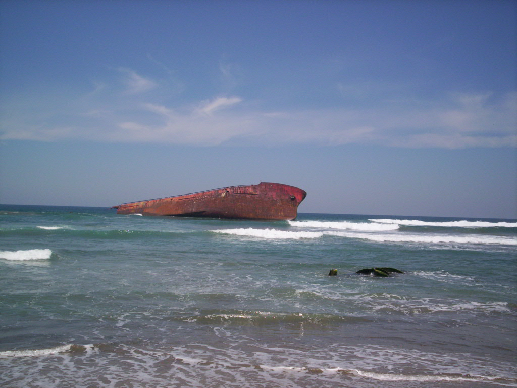
The beach itself is long, open and gently sloping, with soft yellowish sand and a strong, steady surf. That makes it a consistent beach break for surfers, with lefts and rights that work best in summer, but it also means the water deserves respect: the state fisheries commission warned in 2026 of unusual currents here and asked swimmers to follow the lifeguards and Protección Civil. The town was the epicentre of a magnitude 7.2 earthquake on 24 October 1981. Near the Estero del Tigre, a lagoon at the edge of town, lies the rusting hull of the Betula, a ship that ran aground years ago and is now the local sunset photo spot.
Sea turtles are the other draw. Like most of the beaches around it, Playa Azul has turtle-protection camps, including those at Barra de Pichi and Barra de Santa Ana, which collect eggs, incubate them in protected corrals and release the hatchlings. Protection of the three turtle species that nest on this coast began around 1992, and the town now holds a sea turtle festival on the third weekend of October, the 'month of the sea turtle': hatchling releases on the beach in front of the plaza, displays on conservation work, local food stands, a drawing contest and a local surf contest.
How to get to Playa Azul
Drive from Lázaro Cárdenas: 20 min, 25 km
Playa Azul is about 26 km west of Lázaro Cárdenas, reached either on the old road through Acalpican and La Mira or on the four-lane coastal boulevard, which runs past the sea and the estuaries. From Uruapan, Federal Highway 37 runs south through Nueva Italia and Arteaga and ends at Playa Azul; from Morelia the drive is about 331 km, roughly 4 hours. By bus it takes about 5 and a half hours from Morelia with a change in Lázaro Cárdenas, and the town has local and long-distance bus service. The nearest airport is Lázaro Cárdenas (LZC), about 28 km away in a straight line.
Directions to Playa Azul on Google Maps
Distances are in a straight line; the road is usually longer.
Links open a partner site. We may earn a commission if you book, at no cost to you.
From the nearest cities to Playa Azul
- Lázaro Cárdenas · 25 km by road, 20 min
- Zihuatanejo · 119 km by road, 1 h 25 min
- Apatzingán · 214 km by road, 2 h 40 min
Drive times by road from OpenStreetMap, without traffic or stops. Times marked ~ are estimated from the straight-line distance.
Before you go to Playa Azul: hours, prices and tips
- Best time of day
- For surfing, summer brings the cleanest, most consistent waves, July most of all. Surf-Forecast · checked Oct 2026
- Best season
- October is sea turtle month: the turtle festival, with hatchling releases on the beach, is held on the third weekend of the month. México Desconocido · checked Oct 2026
- Rules
- Unusual currents form here: swim only where the lifeguards say it is safe and follow Protección Civil's instructions. Tus Buenas Noticias (Compesca) · checked Oct 2026
Hours and prices change, especially around holidays. Each fact links to where we checked it.
Visiting Playa Azul: what to see and do
Watch the sunset next to the stranded hull of the Betula by the Estero del Tigre.
Surf the consistent open-sea beach break, best in summer.
See a hatchling release at one of the turtle camps, or come for the turtle festival in October.
Visit the estuaries and wetlands at the edge of town.
Eat ceviche and fresh fish at the stands along the beach.
Plan your trip
Places to stay in Playa Azul
Compare hotels, posadas, and rentals in and around Playa Azul.
Tours & activities
Day trips around Zihuatanejo sometimes stop in Playa Azul; a tour is the easy way to see it without a car.
Rental cars
Pick up a car at ZIH (Zihuatanejo): about 12 min by road to Zihuatanejo, then 92 km more to Playa Azul, on your own schedule.
Flights
The nearest airport with scheduled flights is Zihuatanejo (ZIH), about 12 min by road from Zihuatanejo, the base for Playa Azul.
Mobile data
Signal can drop away from Zihuatanejo: download a map of the way to Playa Azul before you set out, or carry an eSIM with data.
Links open a partner site. We may earn a commission if you book, at no cost to you.
Photos
When to go to Playa Azul warm
Playa Azul shares the climate of Zihuatanejo, 92 km away. The best months to visit are January, February, March, and April.
See the month-by-month climate of Zihuatanejo
Weather in Playa Azul now and the next 7 days
Live forecast from Open-Meteo. Chance of rain is the day's highest.
The closest Pueblo Mágico: Zihuatanejo

Zihuatanejo is the Pueblo Mágico closest to Playa Azul, with places to stay, food, and more to see.
Closest to Playa Azul
-
Lázaro Cárdenas · City · 16 km away
-
Caleta de Campos · Town · 44 km away
-
Nexpa · Beach · 48 km away
Near Playa Azul
-
Zihuatanejo · City
1 h 25 min drive · 119 km


Drive times by road from OpenStreetMap, without traffic. Times marked ~ are estimated from the straight-line distance.
Location from OpenStreetMap. Written by Puebloteca.