



Landmark Cabo Corrientes, Jalisco Municipality of Cabo Corrientes Banderas Bay
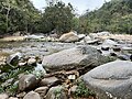
Open-air riverside restaurant at km 20 on the road to El Tuito, on the Horcones River boulders, with cliff divers, river pools and zip lines.
From Puerto Vallarta: 30 min by car (27 km by road) How to get there ↓
Near here
See everything nearby ↓



Plan your visit to Chico's Paradise
Where to stay near Chico's Paradise
Compare hotels, posadas and guest houses in Chico's Paradise.
Tours to Chico's Paradise
Look for tours of the area around Sayulita that stop at Chico's Paradise.
 Tours from Puerto Vallarta
Winner 2026 Downtown Vallarta Food Tour with Vallarta Food Tours
★ 5.0 (3,971) · From US$59
How to get to Chico's Paradise
- From Puerto Vallarta: about 30 min by road (~27 km)
- Nearest airport: Puerto Vallarta (PVR), 41 min by car to Sayulita
Links open a partner site. We may earn a commission if you book, at no cost to you.
Tours from Puerto Vallarta, near Chico's Paradise


Tours, prices and ratings from Viator, checked weekly. We may earn a commission if you book.
About Chico's Paradise
Chico's Paradise is a big open-air restaurant built over the granite boulders of the Horcones River, at kilometre 20 of Highway 200 where the road leaves the coast at Boca de Tomatlán and climbs into the Sierra Madre towards El Tuito. It stands beside the small settlement of Las Juntas y Los Veranos, just inside Cabo Corrientes municipality, about 20 km south of Puerto Vallarta, and for more than four decades it has been one of the classic stops on day trips into the hills behind the bay.
It began very simply. In 1980 the Christian Science Monitor described a thatched, tree-house-like place set above two streams, recently opened by Chico Pérez, a former janitor at a beachfront restaurant, who had no electricity, no phone and closed at sundown. Today the palapa terraces are much larger and step down towards the water, with views over the pools and a small waterfall, and a swaying bridge leads across the rocks.
The kitchen serves home-style Mexican food: guacamole, grilled fish and seafood, barbecued ribs and meats, with strong margaritas; prices are on the high side for the area and portions are big. Much of the fun is watching: local divers leap from the rocks into a pool below and work for tips, and zip-line riders from the canopy tour fly overhead. When the river is calm diners climb down to swim in the pools. Most visitors arrive on a jungle or El Tuito tour from Puerto Vallarta, which usually includes a meal here; signage on the highway is poor, so if you drive yourself watch the kilometre posts.
How to get to Chico's Paradise
Drive from Puerto Vallarta: 30 min, 27 km
Chico's Paradise is at km 20 of Highway 200 south of Puerto Vallarta: follow the coast road past Mismaloya to Boca de Tomatlán, where the highway turns inland up the Horcones valley, and continue a few kilometres to Las Juntas y Los Veranos; the restaurant has its own parking. El Tuito buses leave from Carranza and Aguacate streets in the Zona Romántica every half hour and run along this road (ask the driver to stop at Chico's Paradise). Signs are poor, so many visitors come by taxi or on a tour that includes the stop.
Directions to Chico's Paradise on Google Maps
Distances are in a straight line; the road is usually longer.
Links open a partner site. We may earn a commission if you book, at no cost to you.
From the nearest cities to Chico's Paradise
- Puerto Vallarta · 27 km by road, 30 min
- Autlán · about 165 km by road, ~2 h 25 min
- Tepic · 200 km by road, 2 h 45 min
Drive times by road from OpenStreetMap, without traffic or stops. Times marked ~ are estimated from the straight-line distance.
Before you go to Chico's Paradise: hours, prices and tips
- Hours
- Open daily from 11 am to 6 pm (from noon on Fridays). Wanderlog · checked Oct 2026
- Entry
- No entrance fee; you pay for what you eat. Expect restaurant prices on the high side: a lunch for two came to about 47 US dollars before tip. Forever Karen · checked Oct 2026
- Guide or tour
- No guide needed, but the turn-off is poorly signed, so a taxi or a tour that includes the stop is the easiest way in. Forever Karen · checked Oct 2026
- What to bring
- Small bills to tip the cliff divers, and a swimsuit if you want to get into the river. Wanderlog · checked Oct 2026
Hours and prices change, especially around holidays. Each fact links to where we checked it.
Visiting Chico's Paradise: what to see and do
Eat guacamole, grilled fish or ribs on the palapa terraces above the river.
Watch the local cliff divers jump into the pool below (they work for tips).
Swim in the river pools when the water is calm.
Cross the swaying bridge over the boulders.
Combine the stop with the Vallarta Botanical Garden, 4 km further up the same road.
Plan your trip
Places to stay in Chico's Paradise
Compare hotels, posadas, and rentals in and around Chico's Paradise.
Tours & activities
Look for tours of the area around Sayulita that stop at Chico's Paradise.
Rental cars
Pick up a car at PVR (Puerto Vallarta): about 41 min by road to Sayulita, then 46 km more to Chico's Paradise, on your own schedule.
Flights
The nearest airport with scheduled flights is Puerto Vallarta (PVR), about 41 min by road from Sayulita, the base for Chico's Paradise.
Mobile data
Signal can drop away from Sayulita: download a map of the way to Chico's Paradise before you set out, or carry an eSIM with data.
Links open a partner site. We may earn a commission if you book, at no cost to you.
Photos
When to go to Chico's Paradise warm
Chico's Paradise shares the climate of Sayulita, 46 km away. The best months to visit are March, April, May, and November.
See the month-by-month climate of Sayulita
Weather in Chico's Paradise now and the next 7 days
Live forecast from Open-Meteo. Chance of rain is the day's highest.
The closest Pueblo Mágico: Sayulita

Sayulita is the Pueblo Mágico closest to Chico's Paradise, with places to stay, food, and more to see.
Also close to
- Talpa de Allende · Jalisco · 51 km away
- Mascota · Jalisco · 53 km away
- San Sebastián del Oeste · Jalisco · 76 km away
Closest to Chico's Paradise
-
Las Juntas y los Veranos · Village · 0 km away
-
Jardín Botánico de Vallarta · Nature reserve · 2 km away
-
Boca de Tomatlán · Village · 4 km away
-
Playa Caballo · Beach · 5 km away
-
Playa Colomitos · Beach · 5 km away
-
El Edén de Mismaloya · Landmark · 6 km away
-
Mismaloya · Village · 6 km away
-
Playa Las Ánimas · Beach · 6 km away


Near Chico's Paradise
-
Los Arcos de Mismaloya · Nature reserve · Jalisco
20 min: drive to Playa Mismaloya, then 10 min by boat




Drive times by road from OpenStreetMap, without traffic. Times marked ~ are estimated from the straight-line distance.
Location from OpenStreetMap. Written by Puebloteca.