

Beach Puerto Vallarta, Jalisco Municipality of Puerto Vallarta Banderas Bay
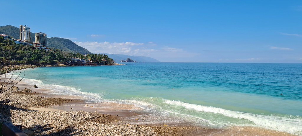
Puerto Vallarta's south-shore public beach: the first Blue Flag beach in Jalisco, with lifeguards, ramps, showers and a city beach club.
From Puerto Vallarta: 15 min by car (11 km by road) How to get there ↓
Near here
See everything nearby ↓


Plan your visit to Playa Palmares
Where to stay near Playa Palmares
Compare hotels, posadas and guest houses in Playa Palmares.
Tours to Playa Palmares
Day trips and guided outings from Sayulita often include Playa Palmares; with a local guide you can get there without a car.
How to get to Playa Palmares
- From Puerto Vallarta: about 15 min by road (~11 km)
- Nearest airport: Puerto Vallarta (PVR), 41 min by car to Sayulita
Links open a partner site. We may earn a commission if you book, at no cost to you.
About Playa Palmares
Playa Palmares is a public beach on Puerto Vallarta's south shore, right beside Highway 200 a short way before the Garza Blanca resort, roughly 6 to 7.5 km south of downtown depending on where you start counting. It is a few hundred meters of sand at the foot of the hills that run down to the bay, with Punta Negra and the Canto Palmares stretch to the north and the rocky coves toward Garza Blanca and Mismaloya to the south. Unusually for this coast, no hotel stands on the sand itself, so the beach feels open and local rather than like a resort's front yard.
In 2014 Palmares became the first beach in the state of Jalisco to receive the Blue Flag, the international award run by the Foundation for Environmental Education; the city's mayor at the time, Ramón Guerrero, announced it. To earn it a beach has to meet more than thirty criteria on water quality, cleanliness, safety and services, and Palmares has the facilities to show for it: public restrooms and showers, lifeguards, a color flag system for sea conditions, wheelchair ramps down to the sand and a large parking lot. On 23 August 2025 the city opened Tuki Playa Palmares here, billed as Puerto Vallarta's first public beach club, as part of a plan for five such clubs along the municipal coast.
The water is usually calm and clear, with bigger waves on choppier days. The north end is sandier and easier to wade into; the south end is rocky, so water shoes help. Canto Palmares is the only sit-down restaurant on the beach, and vendors walk the sand with grilled seafood, fruit and paletas, while umbrellas, kayaks and paddleboards are for rent. A large sculpture by Nicolas Bertoux, The Sail of the Galleon, marks the entrance. Families from town fill it on weekends and in high season, when the lot can be full by late morning, so come early.
How to get to Playa Palmares
Drive from Puerto Vallarta: 15 min, 11 km
Palmares is right on Highway 200 (Carretera a Barra de Navidad), about 6 to 7.5 km south of downtown Puerto Vallarta, around 10 to 17 minutes by car depending on traffic; the large parking lot fills on high-season weekends. By bus, take one marked Mismaloya or Boca de Tomatlán from the Zona Romántica (a common stop is the OXXO at Basilio Badillo and Constitución), tell the driver "Palmares" and carry small change; evening buses back can be full and pass you by. Taxis do not use meters, so agree on the fare first; ride-hailing apps work well on the way out.
Directions to Playa Palmares on Google Maps
Distances are in a straight line; the road is usually longer.
Links open a partner site. We may earn a commission if you book, at no cost to you.
From the nearest cities to Playa Palmares
- Puerto Vallarta · 11 km by road, 15 min
- Autlán · about 165 km by road, ~2 h 25 min
- Tepic · 184 km by road, 2 h 30 min
Drive times by road from OpenStreetMap, without traffic or stops. Times marked ~ are estimated from the straight-line distance.
Before you go to Playa Palmares: hours, prices and tips
- Entry
- Free: it is a public beach. Seats on the restaurant terrace need a food or drink order, and seating on the sand costs extra. Vallarta Adventures · checked Oct 2026
- Guide or tour
- No guide needed; lifeguards are on duty and kayaks and paddleboards are for rent on the beach. Vallarta Adventures · checked Oct 2026
- What to bring
- Water shoes for the rocky south end, and small change for the bus. Vallarta Adventures · checked Oct 2026
- Rules
- Check the colored flags that show sea conditions before you swim; on choppy days the waves get bigger. Vallarta Adventures · checked Oct 2026
Hours and prices change, especially around holidays. Each fact links to where we checked it.
Visiting Playa Palmares: what to see and do
Swim off the sandy north end on a calm morning, under the eye of the Blue Flag lifeguards.
Rent a kayak or paddleboard and follow the rocky shore south toward Garza Blanca.
Eat on the covered terrace of Canto Palmares, the beach's only sit-down restaurant.
See Nicolas Bertoux's sculpture The Sail of the Galleon at the entrance.
Spend a day at Tuki Playa Palmares, the city's first public beach club, opened in 2025.
Stay for sunset over Banderas Bay.
Plan your trip
Places to stay in Playa Palmares
Compare hotels, posadas, and rentals in and around Playa Palmares.
Tours & activities
Day trips and guided outings from Sayulita often include Playa Palmares; with a local guide you can get there without a car.
Rental cars
Pick up a car at PVR (Puerto Vallarta): about 41 min by road to Sayulita, then 39 km more to Playa Palmares, on your own schedule.
Flights
The nearest airport with scheduled flights is Puerto Vallarta (PVR), about 41 min by road from Sayulita, the base for Playa Palmares.
Travel insurance
If you plan on swimming or surfing at Playa Palmares, check that your policy covers it: some plans leave adventure activities out.
Mobile data
Signal can drop away from Sayulita: download a map of the way to Playa Palmares before you set out, or carry an eSIM with data.
Links open a partner site. We may earn a commission if you book, at no cost to you.
Photos
When to go to Playa Palmares warm
Playa Palmares shares the climate of Sayulita, 39 km away. The best months to visit are March, April, May, and November.
Playa Palmares is best for swimming and time on the water in the warmest months (June, July, and August); in the rainiest ones (July, August, and September) expect storms in the afternoon.
See the month-by-month climate of Sayulita
Weather in Playa Palmares now and the next 7 days
Live forecast from Open-Meteo. Chance of rain is the day's highest.
The closest Pueblo Mágico: Sayulita

Sayulita is the Pueblo Mágico closest to Playa Palmares, with places to stay, food, and more to see.
Also close to
- Talpa de Allende · Jalisco · 49 km away
- Mascota · Jalisco · 49 km away
- San Sebastián del Oeste · Jalisco · 71 km away
Closest to Playa Palmares
-
La Punta Negra · Village · 0 km away
-
Cascada Palo María · Waterfall · 1 km away
-
Playa Garza Blanca · Beach · 1 km away
-
Ecoparque El Nogalito · Landmark · 2 km away
-
Playa Las Estacas · Beach · 3 km away
-
El Edén de Mismaloya · Landmark · 4 km away
-
Los Arcos de Mismaloya · Nature reserve · 4 km away
-
Mismaloya · Village · 4 km away


Near Playa Palmares


Drive times by road from OpenStreetMap, without traffic. Times marked ~ are estimated from the straight-line distance.
Lists with Playa Palmares
Beaches in Jalisco · 20 Beaches near Puerto Vallarta · 40 Beaches near Sayulita · 42 Beaches near Mascota · 16 Beaches near Talpa de Allende · 17Location from OpenStreetMap. Written by Puebloteca.