
Town Ixtlahuacán de los Membrillos, Jalisco
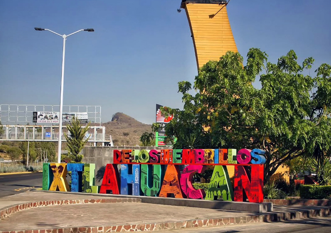
Quince-growing town on the Guadalajara–Chapala highway, with Santiago on horseback at its entrance, a 400-year-old sabino tree and a 25 July fiesta.
From Guadalajara: 40 min by car (43 km by road) How to get there ↓
Near here
See everything nearby ↓



Plan your visit to Ixtlahuacán de los Membrillos
Where to stay near Ixtlahuacán de los Membrillos
Compare hotels, posadas and guest houses in Ixtlahuacán de los Membrillos.
Tours to Ixtlahuacán de los Membrillos
Day trips around Ajijic sometimes stop in Ixtlahuacán de los Membrillos; a tour is the easy way to see it without a car.
 Tours from Guadalajara
Full Day Tour to Tequila and Amatitán with Fun and Culture
★ 4.9 (751) · From US$44
How to get to Ixtlahuacán de los Membrillos
- From Guadalajara: about 40 min by road (~43 km)
- Nearest airport: Guadalajara (GDL), 39 min by car to Ajijic
Links open a partner site. We may earn a commission if you book, at no cost to you.
Tours from Guadalajara, near Ixtlahuacán de los Membrillos


Tours, prices and ratings from Viator, checked weekly. We may earn a commission if you book.
About Ixtlahuacán de los Membrillos
Ixtlahuacán de los Membrillos is the seat of the municipality of the same name, on the Guadalajara–Chapala highway about ten minutes north of Chapala and twenty minutes south of Guadalajara airport, at around 1,600 metres above sea level. At the 2020 census it had 9,561 people, and the municipality is part of the Guadalajara metropolitan area. The name comes from Nahuatl and is usually translated as "place of plains"; "de los Membrillos" refers to the many quince orchards that once grew here, and quince is still the local product, made into a punch, a thick fruit paste (ate) and cajeta.
The story of its founding mixes records and legend. Between 1513 and 1534 a group from Tlajomulco led by Francisco Tepotzin lived at El Varal, a spot at the foot of El Picacho hill. Around 1533, tradition says, a revelation warned them that the site would sink and that they should look, at night and facing east, for a very bright light; it was the reflection of the morning star, Venus, in the pools formed by the El Ojo de Agua spring, and that is where they settled. Beside the spring stands a sabino (Montezuma cypress) more than four centuries old. In 1537 the Tecuexe chief Chapalac arrived with eighty families, and together the two groups founded the town without any Spanish involvement; Chapalac himself later moved on south to what is now Chapala.
The patron saint is the Apostle James (Santiago). At the town entrance, beside the colourful name letters, a tall column carries his figure on horseback, and the parish church of Santiago Apóstol stands in the centre. The patron saint's fiesta lasts about ten days around 25 July, with a novena, church bells, rockets and music at dawn, and coincides with the quince harvest. The municipality keeps several old hacienda buildings and the Atequiza theatre, built in 1886, and the Santiago river runs through it.
How to get to Ixtlahuacán de los Membrillos
Drive from Guadalajara: 40 min, 43 km
Ixtlahuacán is on the Guadalajara–Chapala highway, about 44 km from central Guadalajara (roughly 35 minutes by car) and some 20 minutes south of the airport. Chapala is about 10 minutes further south, and Ajijic, the nearest Pueblo Mágico, a little beyond along the lakeshore. By bus, Chapala Plus runs hourly from Guadalajara's Antigua Central Camionera (Central Vieja) and reaches Ixtlahuacán in about an hour and a quarter. The Macrolibramiento ring road towards Puerto Vallarta or Guanajuato is also reachable from town.
Directions to Ixtlahuacán de los Membrillos on Google Maps
Distances are in a straight line; the road is usually longer.
Links open a partner site. We may earn a commission if you book, at no cost to you.
From the nearest cities to Ixtlahuacán de los Membrillos
- Guadalajara · 43 km by road, 40 min
- Ocotlán · 60 km by road, 55 min
- Tepatitlán · 84 km by road, 1 h 20 min
Drive times by road from OpenStreetMap, without traffic or stops. Times marked ~ are estimated from the straight-line distance.
Before you go to Ixtlahuacán de los Membrillos: hours, prices and tips
- Best season
- Patron saint's day of Santiago Apóstol on 25 July, preceded by a novena; Holy Cross day in May; Saint Cecilia in November; Virgin of Guadalupe and Immaculate Conception in December. INAFED, Enciclopedia de los Municipios de México · checked Oct 2026
Hours and prices change, especially around holidays. Each fact links to where we checked it.
Visiting Ixtlahuacán de los Membrillos: what to see and do
The monument to Santiago on horseback and the colourful name letters at the town entrance.
The parish church of Santiago Apóstol.
The sabino tree, more than four centuries old, beside the El Ojo de Agua spring.
Quince punch, ate and quince cajeta, the town's signature products.
The Atequiza theatre of 1886 and the old hacienda buildings of the municipality.
Plan your trip
Places to stay in Ixtlahuacán de los Membrillos
Compare hotels, posadas, and rentals in and around Ixtlahuacán de los Membrillos.
Tours & activities
Day trips around Ajijic sometimes stop in Ixtlahuacán de los Membrillos; a tour is the easy way to see it without a car.
Rental cars
Pick up a car at GDL (Guadalajara): about 39 min by road to Ajijic, then 9 km more to Ixtlahuacán de los Membrillos, on your own schedule.
Flights
The nearest airport with scheduled flights is Guadalajara (GDL), about 39 min by road from Ajijic, the base for Ixtlahuacán de los Membrillos.
Mobile data
Signal can drop away from Ajijic: download a map of the way to Ixtlahuacán de los Membrillos before you set out, or carry an eSIM with data.
Links open a partner site. We may earn a commission if you book, at no cost to you.
When to go to Ixtlahuacán de los Membrillos mild
Ixtlahuacán de los Membrillos shares the climate of Ajijic, 9 km away. The best months to visit are January, March, April, and November.
See the month-by-month climate of Ajijic
Weather in Ixtlahuacán de los Membrillos now and the next 7 days
Live forecast from Open-Meteo. Chance of rain is the day's highest.
The closest Pueblo Mágico: Ajijic

Ajijic is the Pueblo Mágico closest to Ixtlahuacán de los Membrillos, with places to stay, food, and more to see.
Also close to
- Tlaquepaque · Jalisco · 35 km away
- Mazamitla · Jalisco · 51 km away
- Jiquilpan · Michoacán · 63 km away
- Cocula · Jalisco · 66 km away
- Sayula · Jalisco · 67 km away
Closest to Ixtlahuacán de los Membrillos
-
Santa Cruz de la Soledad · Village · 5 km away
-
Chapala · Town · 6 km away
-
Atequiza · Town · 7 km away
-
Atotonilquillo · Town · 9 km away
-
Isla de los Alacranes · Nature reserve · 11 km away
-
Cajititlán · Town · 15 km away
-
Laguna de Cajititlán · Lake · 16 km away
-
San Juan Cosalá · Hot springs · 17 km away


Near Ixtlahuacán de los Membrillos


Drive times by road from OpenStreetMap, without traffic. Times marked ~ are estimated from the straight-line distance.
Location from OpenStreetMap. Written by Puebloteca.