
Mountain San Pedro Tlaquepaque, Jalisco Municipality of San Pedro Tlaquepaque
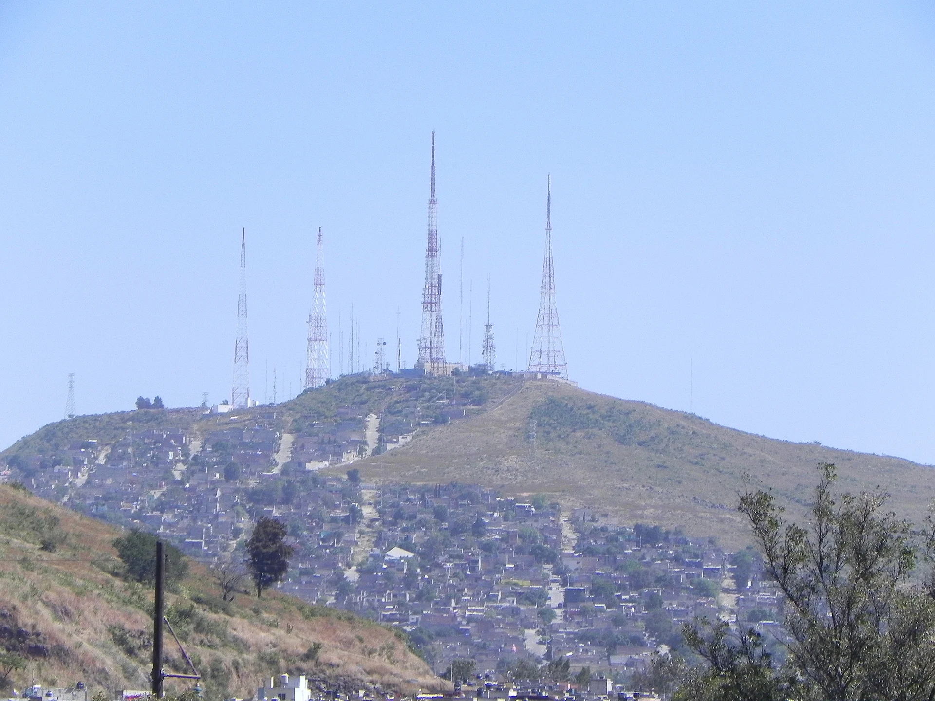
Extinct scoria hill of about 1,870 m in Tlaquepaque, the highest point of the Guadalajara metro area, topped with broadcast antennas.
From Guadalajara: 15 min by car (12 km by road) How to get there ↓
Near here
See everything nearby ↓


Plan your visit to Cerro del Cuatro
Where to stay near Cerro del Cuatro
Compare hotels, posadas and guest houses in Cerro del Cuatro.
Tours to Cerro del Cuatro
Day trips and guided outings from Tlaquepaque often include Cerro del Cuatro; with a local guide you can get there without a car.
 Tours from Guadalajara
Full Day Tour to Tequila and Amatitán with Fun and Culture
★ 4.9 (751) · From US$44
How to get to Cerro del Cuatro
- From Guadalajara: about 15 min by road (~12 km)
- Nearest airport: Guadalajara (GDL), 26 min by car to Tlaquepaque
Links open a partner site. We may earn a commission if you book, at no cost to you.
Tours from Guadalajara, near Cerro del Cuatro


Tours, prices and ratings from Viator, checked weekly. We may earn a commission if you book.
About Cerro del Cuatro
Cerro del Cuatro is a hill on the southern edge of the Guadalajara metropolitan area, inside the municipality of San Pedro Tlaquepaque, part of the Trans-Mexican Volcanic Belt. It is regarded as the highest point of the metro area at about 1,870 m above sea level and is described as an extinct scoria volcano. From the city it is easy to pick out by the cluster of broadcast towers on its summit.
The name does not come from the antennas, as many people assume, but from the Revolution: on 8 July 1914 the 4th Infantry Battalion under Álvaro Obregón entered Guadalajara after Victoriano Huerta's defeat, and the hill took the battalion's number; Avenida 8 de Julio recalls the date. The television antennas went up in the 1980s, along with air-pollution monitors installed by the state government.
Housing has crept up the slopes: irregular settlements in Tlaquepaque cover more than half of the hill, and part of it has been fenced off for protection. The top remains a large undeveloped area of scrub, grass and wildflowers, used as a lookout over Guadalajara and for watching storms roll over the city. One side has a steep, rocky mountain-bike descent, and in 2014 volunteers planted 250 trees there, among them ash, rosa morada, mezquite and red cedar.
How to get to Cerro del Cuatro
Drive from Guadalajara: 15 min, 12 km
The hill lies on the southern edge of the metro area, about 2 km north of the Periférico, and according to a 2014 guide it can only be reached from the north. The suggested starting point is the corner of Jesús Reyes Heroles and Antonio Castro (colonia Polanquito, Tlaquepaque); from there head south on Castro, which becomes Paseo Cerro del Cuatro. It is about 3 km of winding road up to the antennas, with parking near them. From central Tlaquepaque it is about 7 km as the crow flies and from Guadalajara about 8 km (roughly 10 minutes by car, approximate). A walking route of about 3.5 km is rated easy. Road conditions may have changed since 2014, so check a map before going.
Directions to Cerro del Cuatro on Google Maps
Distances are in a straight line; the road is usually longer.
Links open a partner site. We may earn a commission if you book, at no cost to you.
From the nearest cities to Cerro del Cuatro
- Guadalajara · 12 km by road, 15 min
- Tepatitlán · 77 km by road, 1 h 5 min
- Ocotlán · 85 km by road, 1 h 10 min
Drive times by road from OpenStreetMap, without traffic or stops. Times marked ~ are estimated from the straight-line distance.
Before you go to Cerro del Cuatro: hours, prices and tips
- What to bring
- Water, sun protection, comfortable shoes and a map or GPS if you don't know the area. Hispanopedia · checked Oct 2026
Hours and prices change, especially around holidays. Each fact links to where we checked it.
Visiting Cerro del Cuatro: what to see and do
The summit with its broadcast towers, the highest point in the metro area
Lookouts over Guadalajara and the storms crossing the city
The undeveloped scrub and grassland, with wildflowers in the rainy season
The mountain-bike descent on one of the slopes
Avenida 8 de Julio, which keeps the date of Obregón's entry into Guadalajara
Plan your trip
Places to stay in Cerro del Cuatro
Compare hotels, posadas, and rentals in and around Cerro del Cuatro.
Tours & activities
Day trips and guided outings from Tlaquepaque often include Cerro del Cuatro; with a local guide you can get there without a car.
Rental cars
Pick up a car at GDL (Guadalajara): about 26 min by road to Tlaquepaque, then 7 km more to Cerro del Cuatro, on your own schedule.
Flights
The nearest airport with scheduled flights is Guadalajara (GDL), about 26 min by road from Tlaquepaque, the base for Cerro del Cuatro.
Travel insurance
If you plan on hiking at altitude at Cerro del Cuatro, check that your policy covers it: some plans leave adventure activities out.
Mobile data
Signal can drop away from Tlaquepaque: download a map of the way to Cerro del Cuatro before you set out, or carry an eSIM with data.
Links open a partner site. We may earn a commission if you book, at no cost to you.
When to go to Cerro del Cuatro mild
Cerro del Cuatro shares the climate of Tlaquepaque, 7 km away. The best months to visit are January, March, November, and December.
For the clearest views from Cerro del Cuatro, go in the driest months (January, March, April, and May); in the rains, clouds tend to build up by midday.
See the month-by-month climate of Tlaquepaque
Weather in Cerro del Cuatro now and the next 7 days
Live forecast from Open-Meteo. Chance of rain is the day's highest.
The closest Pueblo Mágico: Tlaquepaque

Tlaquepaque is the Pueblo Mágico closest to Cerro del Cuatro, with places to stay, food, and more to see.
Also close to
Closest to Cerro del Cuatro
-
Bosque Urbano Tlaquepaque · Nature reserve · 5 km away
-
Parque González Gallo · Nature reserve · 6 km away
-
Analco · Village · 8 km away
-
Colonia Americana · Landmark · 8 km away
-
Parque Revolución · Nature reserve · 8 km away
-
El Ixtépete · Archaeological site · 9 km away
-
Parque Morelos · Nature reserve · 9 km away
-
Parque Alcalde · Nature reserve · 10 km away


Near Cerro del Cuatro


Drive times by road from OpenStreetMap, without traffic. Times marked ~ are estimated from the straight-line distance.
Lists with Cerro del Cuatro
Mountains in Jalisco · 6Location from OpenStreetMap. Written by Puebloteca.