
Town Tlajomulco de Zúñiga, Jalisco Municipality of Tlajomulco de Zúñiga
Old Franciscan town in Tlajomulco off López Mateos Sur, with a carved-stone Refugio chapel, an archaeology museum and a November float parade.
From Guadalajara: 25 min by car (22 km by road) How to get there ↓
Near here
See everything nearby ↓


Plan your visit to San Agustín
Where to stay near San Agustín
Compare hotels, posadas and guest houses in San Agustín.
Tours to San Agustín
Day trips around Tlaquepaque sometimes stop in San Agustín; a tour is the easy way to see it without a car.
 Tours from Guadalajara
Full Day Tour to Tequila and Amatitán with Fun and Culture
★ 4.9 (751) · From US$44
How to get to San Agustín
- From Guadalajara: about 25 min by road (~22 km)
- Nearest airport: Guadalajara (GDL), 26 min by car to Tlaquepaque
Links open a partner site. We may earn a commission if you book, at no cost to you.
Tours from Guadalajara, near San Agustín


Tours, prices and ratings from Viator, checked weekly. We may earn a commission if you book.
About San Agustín
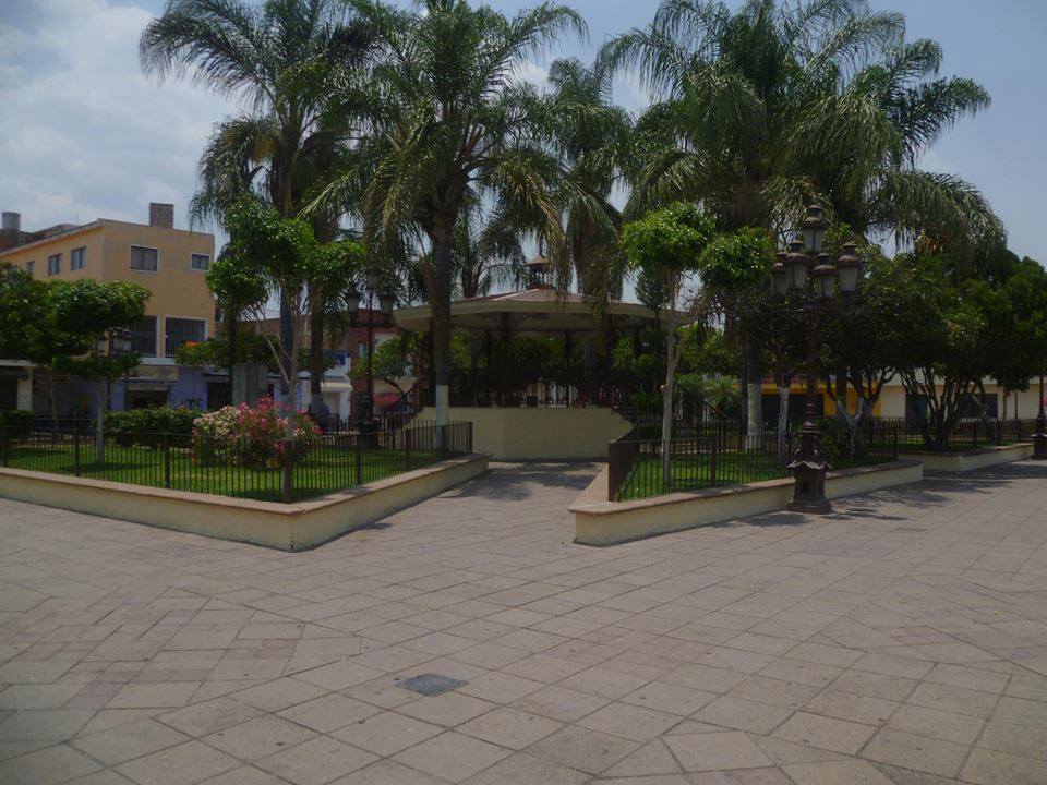
San Agustín is a district in the northwest of Tlajomulco de Zúñiga, at 1,594 metres in the Zapotepec valley, an extension of the Toluquilla valley, about 20 km from central Guadalajara and 13 km from the municipal seat. For a time it was officially named Nicolás R. Casillas, after a revolutionary colonel. With 49,402 people at the 2020 census it is now almost a city, ringed by housing developments, but its centre keeps the layout of a village: a plaza with a bandstand, the district office, the market and Sunday evening fairs.
Its founding probably dates to 1542, with Indigenous settlers from Apozol and Juchipila. The Indigenous name, Sapotepec, means "on the hill of the zapote"; the name San Agustín appears in Franciscan chronicles from the mid-16th century. The village was served from the Franciscan convent in Guadalajara and later from the mission of Santiago de Tlajomulco, and it is part of the Franciscan Route. In 1942 the Franciscans opened the Colegio Seráfico here, the first formation house of their Jalisco province; residents agreed to wash the seminarians' clothes, and local women cooked for them some days without pay.
Facing the main church is the chapel of Nuestra Señora del Refugio, which began as the chapel of the Indigenous hospital, dedicated to the Immaculate Conception, and changed its dedication in the 18th century. Inside it has Baroque stone arches and door frames carved with flowers and rosettes, and a carved date of 1872. The Greek-cross church of San Agustín was rebuilt from 1935 after the original collapsed, roofed in 1948 and finished in 1980. Half a block away, the Casa de la Cultura holds a two-room archaeology museum with more than a hundred late Classic pieces from western Mexico: obsidian blades and points, jewellery, figurines, spindle whorls and pots. The surrounding hills, such as El Sapo and La Herradura, have pre-Hispanic terraces and mounds, and between El Picacho and La Herradura lies a basalt petroglyph about 3 metres across known as La Rosetta.
The fiesta of the Virgen del Refugio runs from 25 June to 4 July; on 3 July her image is carried in a procession of about 8 km to Los Ocotes, and on the 4th there are dawn serenades, a procession with the original painting brought by Franciscans in 1711, and fireworks. In late August Saint Augustine is honoured with a procession in which people enter the church carrying maize plants, and in November there is a parade of floats.
How to get to San Agustín
Drive from Guadalajara: 25 min, 22 km
The usual way in is along Avenida Adolfo López Mateos Sur (the Guadalajara–Morelia road). From central Guadalajara it is about 22 km, roughly 25 min without traffic, although López Mateos jams at rush hour and the trip can take over 50 min. From central Tlaquepaque, the nearest Pueblo Mágico, it is about 25 km, roughly 30 min, and from the Tlajomulco municipal seat about 13 km.
By public transport, Mi Transporte route C127-V1 runs along López Mateos Sur to San Agustín about every 30 minutes, and Ómnibus de la Ribera runs hourly along the same avenue. Mi Transporte routes and maps are published by Jalisco's transport department at setran.jalisco.gob.mx.
Directions to San Agustín on Google Maps
Distances are in a straight line; the road is usually longer.
Links open a partner site. We may earn a commission if you book, at no cost to you.
From the nearest cities to San Agustín
- Guadalajara · 22 km by road, 25 min
- Tepatitlán · 94 km by road, 1 h 15 min
- Ciudad Guzmán · 109 km by road, 1 h 20 min
Drive times by road from OpenStreetMap, without traffic or stops. Times marked ~ are estimated from the straight-line distance.
Before you go to San Agustín: hours, prices and tips
- Best season
- Virgen del Refugio 25 June–4 July (procession to Los Ocotes on 3 July); San Agustín 25–28 August; float parade on the third-to-last Sunday of November, with fiestas until the last Sunday of the month. Wikipedia (es) · checked Oct 2026
Hours and prices change, especially around holidays. Each fact links to where we checked it.
Visiting San Agustín: what to see and do
The chapel of Nuestra Señora del Refugio, once the Indigenous hospital chapel, with carved stone arches and door frames.
The Greek-cross church of San Agustín, facing the chapel.
The archaeology museum in the Casa de la Cultura, with more than a hundred late Classic pieces.
The main plaza with its bandstand, the market and the Sunday evening fairs.
The Virgen del Refugio procession to Los Ocotes on 3 July.
The November parade of floats.
Plan your trip
Places to stay in San Agustín
Compare hotels, posadas, and rentals in and around San Agustín.
Tours & activities
Day trips around Tlaquepaque sometimes stop in San Agustín; a tour is the easy way to see it without a car.
Rental cars
Pick up a car at GDL (Guadalajara): about 26 min by road to Tlaquepaque, then 19 km more to San Agustín, on your own schedule.
Flights
The nearest airport with scheduled flights is Guadalajara (GDL), about 26 min by road from Tlaquepaque, the base for San Agustín.
Mobile data
Signal can drop away from Tlaquepaque: download a map of the way to San Agustín before you set out, or carry an eSIM with data.
Links open a partner site. We may earn a commission if you book, at no cost to you.
When to go to San Agustín mild
San Agustín shares the climate of Tlaquepaque, 19 km away. The best months to visit are January, March, November, and December.
See the month-by-month climate of Tlaquepaque
Weather in San Agustín now and the next 7 days
Live forecast from Open-Meteo. Chance of rain is the day's highest.
The closest Pueblo Mágico: Tlaquepaque

Tlaquepaque is the Pueblo Mágico closest to San Agustín, with places to stay, food, and more to see.
Also close to
Closest to San Agustín
-
Santa Anita · Town · 3 km away
-
El Ixtépete · Archaeological site · 10 km away
-
Cerro del Cuatro · Mountain · 12 km away
-
Parque Metropolitano de Guadalajara · Nature reserve · 14 km away
-
Bosque La Primavera · Nature reserve · 15 km away
-
Bosque Urbano Tlaquepaque · Nature reserve · 18 km away
-
Colonia Americana · Landmark · 18 km away
-
Parque González Gallo · Nature reserve · 18 km away


Near San Agustín


Drive times by road from OpenStreetMap, without traffic. Times marked ~ are estimated from the straight-line distance.
Location from OpenStreetMap. Written by Puebloteca.