
Village Guadalajara, Jalisco Municipality of Guadalajara
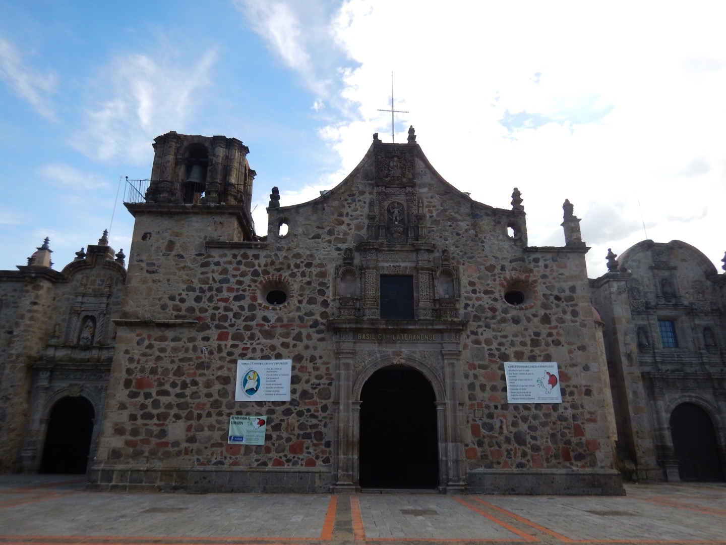
A founding barrio of Guadalajara across the old San Juan de Dios river, with the San Sebastián temple and its garden with a bandstand.
From Tepatitlán: 1 h by car (74 km by road) How to get there ↓
Near here
See everything nearby ↓


Plan your visit to Analco
Where to stay near Analco
Compare hotels, posadas and guest houses in Analco.
Tours to Analco
Day trips and guided outings from Tlaquepaque often include Analco; with a local guide you can get there without a car.
 Analco Walking Tour: History and street Food in Guadalajara
★ 5.0 (9) · From US$83
How to get to Analco
- From Tepatitlán: about 1 h by road (~74 km)
- Nearest airport: Guadalajara (GDL), 26 min by car to Tlaquepaque
Links open a partner site. We may earn a commission if you book, at no cost to you.
Popular tours to Analco

Tours, prices and ratings from Viator, checked weekly. We may earn a commission if you book.
About Analco
Analco is one of the barrios Guadalajara was born with. Its name is Nahuatl and means across the river: the river was the San Juan de Dios, now piped beneath Calzada Independencia, and Mexicaltzingo lay on the far bank. It was founded around 1543, alongside the city's last settlement in the Atemajac valley, as a town of Coca and Tecuexe people under Franciscan care. It stayed a separate town until 1821, when it was folded into the capital as just another barrio.
The heart is the Templo de San Sebastián de Analco and its garden with a bandstand. The church began as an adobe hermitage with a thatched roof, raised by the indigenous residents themselves; the first written mention dates from 1560 and most of what stands today is from the second half of the 17th century. It has a basilica plan of three aisles and five bays, with chapels of the Virgin of Guadalupe and of the Calvary. In the garden are bronzes of Cuauhtémoc and of Tenamaztli, the leader of the Mixtón War, and a monument to the victims of the 22 April 1992 explosions.
Other eras have left traces around it. The Patio de los Ángeles, with arcades brought from the former convent of the Agustinas Recoletas, is a cultural centre of the Jalisco Secretaría de Cultura. At Plaza de la Bandera the arches of the old San Pedro toll gate were rebuilt. The barrio was home to silversmiths, shoemakers, carpenters and blacksmiths, and to a community of Japanese families; the Nichiboku institute is still at Guadalupe Victoria 131. The cantina La Sin Rival is billed as the oldest in the area.
How to get to Analco
Drive from Tepatitlán: 1 h, 74 km
Analco is in central Guadalajara, east of Calzada Independencia, between Cuauhtémoc and 28 de Enero streets. From the historic centre it is about 2 km, close to half an hour on foot. To find it, enter Templo de San Sebastián de Analco in your phone map.
For intercity buses, the site of the old Panteón de los Ángeles, inside the barrio, was later taken by the former Central Camionera (the Central Vieja), where line buses such as those to Chapala depart; the Nueva Central Camionera is in Tlaquepaque. Tlaquepaque, the nearest Pueblo Mágico, is about 5.6 km and 7 minutes away by car. No urban bus routes specific to the barrio are published.
Directions to Analco on Google Maps
Distances are in a straight line; the road is usually longer.
Links open a partner site. We may earn a commission if you book, at no cost to you.
From the nearest cities to Analco
- Tepatitlán · 74 km by road, 1 h
- Ocotlán · 82 km by road, 1 h 5 min
- Arandas · 127 km by road, 1 h 45 min
Drive times by road from OpenStreetMap, without traffic or stops. Times marked ~ are estimated from the straight-line distance.
Visiting Analco: what to see and do
Templo de San Sebastián de Analco, with its Baroque facade and 17th-century atrium
Analco garden, with a bandstand, bronzes of Cuauhtémoc and Tenamaztli and the monument to the victims of the 1992 explosions
Patio de los Ángeles, a cultural centre with arcades from the former Agustinas Recoletas convent
Plaza de la Bandera, with the rebuilt arches of the San Pedro toll gate
Cantina La Sin Rival and the Mercado Ayuntamiento
Plan your trip
Places to stay in Analco
Compare hotels, posadas, and rentals in and around Analco.
Tours & activities
Day trips and guided outings from Tlaquepaque often include Analco; with a local guide you can get there without a car.
Rental cars
Pick up a car at GDL (Guadalajara): about 26 min by road to Tlaquepaque, then 4 km more to Analco, on your own schedule.
Flights
The nearest airport with scheduled flights is Guadalajara (GDL), about 26 min by road from Tlaquepaque, the base for Analco.
Mobile data
Signal can drop away from Tlaquepaque: download a map of the way to Analco before you set out, or carry an eSIM with data.
Links open a partner site. We may earn a commission if you book, at no cost to you.
When to go to Analco mild
Analco shares the climate of Tlaquepaque, 4 km away. The best months to visit are January, March, November, and December.
See the month-by-month climate of Tlaquepaque
Weather in Analco now and the next 7 days
Live forecast from Open-Meteo. Chance of rain is the day's highest.
The closest Pueblo Mágico: Tlaquepaque

Tlaquepaque is the Pueblo Mágico closest to Analco, with places to stay, food, and more to see.
Also close to
Closest to Analco
-
Parque González Gallo · Nature reserve · 2 km away
-
Parque Morelos · Nature reserve · 2 km away
-
Parque Revolución · Nature reserve · 2 km away
-
Colonia Americana · Landmark · 3 km away
-
Parque Alcalde · Nature reserve · 3 km away
-
Bosque Urbano Tlaquepaque · Nature reserve · 6 km away
-
Cerro del Cuatro · Mountain · 8 km away
-
Barranca de Huentitán · Nature reserve · 9 km away


Near Analco


Drive times by road from OpenStreetMap, without traffic. Times marked ~ are estimated from the straight-line distance.
Location from OpenStreetMap. Written by Puebloteca.