
Village Zapopan, Jalisco Municipality of Zapopan
Village on the rim of the Río Santiago canyon north of Zapopan, with an old church, nearby archaeological sites and the Tastoanes fiesta in July.
From Guadalajara: 35 min by car (31 km by road) How to get there ↓
Near here
See everything nearby ↓


Plan your visit to San Francisco de Ixcatán
Where to stay near San Francisco de Ixcatán
Compare hotels, posadas and guest houses in San Francisco de Ixcatán.
Tours to San Francisco de Ixcatán
Day trips and guided outings from Tlaquepaque often include San Francisco de Ixcatán; with a local guide you can get there without a car.
How to get to San Francisco de Ixcatán
- From Guadalajara: about 35 min by road (~31 km)
- Nearest airport: Guadalajara (GDL), 26 min by car to Tlaquepaque
Links open a partner site. We may earn a commission if you book, at no cost to you.
About San Francisco de Ixcatán
San Francisco de Ixcatán lies in the north of Zapopan municipality on the rim of the Río Santiago canyon, about 15 km due north of Guadalajara and roughly 1,100 metres above sea level; the river runs some 200 metres below. It belongs to the Barranca del Río Santiago protected natural area and has a few hundred residents (421 at the 2020 census, according to Pueblos América). The name is said to come from the Nahuatl ixcatl, cotton, and tlan, place.
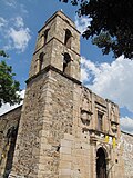
On the plaza stands a small, old church whose foundation a local resident, Don José Casillas, dates to 1590. The area was home to Tecuexes and other peoples who resisted the Spanish for about twenty years until the Mixtón War (1540-1542), and a mural on a school wall recalls that battle. The resistance is remembered each year at the Tastoanes fiesta, 24 to 27 July, with food, drummers and a re-enactment of the fight. Wikipedia lists San Francisco Ixcatán among the archaeological sites of the canyon, where shaft-tomb funerary offerings have been found, and local guides offer visits to La Piedra Grande, with 46 pictographs, and La Cofradía, a kilometre away, with a pyramid about 15 metres high.
A footpath drops from the village toward the river, with the vegetation changing every few metres of descent: cuachalalate, guaje, cacuistle and canyon mangoes. Today the village also has urban gardens, guided trails and the CEIBA community library, run by women of the community, with about 2,500 books. The Huaxtla waterfalls are nearby and are visited from the community of Huaxtla.
How to get to San Francisco de Ixcatán
Drive from Guadalajara: 35 min, 31 km
Ixcatán is about 15 km due north of Guadalajara. By car it takes roughly 45 minutes from central Zapopan: take the road to Tesistán, then the turn-off toward Ixcatán. Buses also run from the Zapopan terminal, but service is infrequent, so check times before you go and plan the return trip. From Guadalajara the practical way is to reach Zapopan first and continue on the same route. The last stretch descends toward the canyon, so in the rainy season a car in good condition is advisable.
Directions to San Francisco de Ixcatán on Google Maps
Distances are in a straight line; the road is usually longer.
Links open a partner site. We may earn a commission if you book, at no cost to you.
From the nearest cities to San Francisco de Ixcatán
- Guadalajara · 31 km by road, 35 min
- Tepatitlán · 104 km by road, 1 h 30 min
- Ocotlán · 112 km by road, 1 h 35 min
Drive times by road from OpenStreetMap, without traffic or stops. Times marked ~ are estimated from the straight-line distance.
Before you go to San Francisco de Ixcatán: hours, prices and tips
- Best season
- Tastoanes fiesta, 24 to 27 July. The Guadalajara Reporter · checked Oct 2026
- Guide or tour
- Walks to the river and archaeological sites are led by a local resident, Don José Casillas; tours are free and a meal can be added for 40 pesos per person (figure from around 2015). Tours: Viator GetYourGuide The Guadalajara Reporter · checked Oct 2026
Hours and prices change, especially around holidays. Each fact links to where we checked it.
Visiting San Francisco de Ixcatán: what to see and do
Church of San Francisco de Asís on the plaza, its foundation dated to 1590 by a local resident
Mural of the Mixtón War battle on a school wall
Pre-Hispanic footpath down to the Río Santiago, through canyon vegetation
La Piedra Grande (46 pictographs) and La Cofradía (pyramid about 15 m), with a local guide
CEIBA community library and urban gardens
Huaxtla waterfalls, visited from the community of Huaxtla
Plan your trip
Places to stay in San Francisco de Ixcatán
Compare hotels, posadas, and rentals in and around San Francisco de Ixcatán.
Tours & activities
Day trips and guided outings from Tlaquepaque often include San Francisco de Ixcatán; with a local guide you can get there without a car.
Rental cars
Pick up a car at GDL (Guadalajara): about 26 min by road to Tlaquepaque, then 25 km more to San Francisco de Ixcatán, on your own schedule.
Flights
The nearest airport with scheduled flights is Guadalajara (GDL), about 26 min by road from Tlaquepaque, the base for San Francisco de Ixcatán.
Mobile data
Signal can drop away from Tlaquepaque: download a map of the way to San Francisco de Ixcatán before you set out, or carry an eSIM with data.
Links open a partner site. We may earn a commission if you book, at no cost to you.
When to go to San Francisco de Ixcatán mild
San Francisco de Ixcatán shares the climate of Tlaquepaque, 25 km away. The best months to visit are January, March, November, and December.
See the month-by-month climate of Tlaquepaque
Weather in San Francisco de Ixcatán now and the next 7 days
Live forecast from Open-Meteo. Chance of rain is the day's highest.
The closest Pueblo Mágico: Tlaquepaque

Tlaquepaque is the Pueblo Mágico closest to San Francisco de Ixcatán, with places to stay, food, and more to see.
Also close to
- Tequila · Jalisco · 51 km away
- Ajijic · Jalisco · 63 km away
- Teúl de González Ortega · Zacatecas · 68 km away
- Cocula · Jalisco · 74 km away
- Temacapulín · Jalisco · 75 km away
Closest to San Francisco de Ixcatán
-
Valle de los Molinos · Town · 9 km away
-
Barranca de Huentitán · Nature reserve · 14 km away
-
Parque Mirador Independencia · Viewpoint · 14 km away
-
Tesistán · Town · 16 km away
-
Parque Alcalde · Nature reserve · 19 km away
-
Parque Morelos · Nature reserve · 20 km away
-
Colonia Americana · Landmark · 21 km away
-
Parque Revolución · Nature reserve · 21 km away


Near San Francisco de Ixcatán


Drive times by road from OpenStreetMap, without traffic. Times marked ~ are estimated from the straight-line distance.
Location from OpenStreetMap. Written by Puebloteca.