Town Zapotlanejo, Jalisco
The clothing town east of Guadalajara: thousands of clothes shops, the Macro Tianguis and the Calderón Bridge, where Hidalgo was defeated in 1811.
From Guadalajara: 30 min by car (32 km by road) How to get there ↓
Near here
See everything nearby ↓


Plan your visit to Zapotlanejo
Where to stay near Zapotlanejo
Compare hotels, posadas and guest houses in Zapotlanejo.
Tours to Zapotlanejo
Day trips around Tlaquepaque sometimes stop in Zapotlanejo; a tour is the easy way to see it without a car.
 Tours from Guadalajara
Full Day Tour to Tequila and Amatitán with Fun and Culture
★ 4.9 (751) · From US$44
How to get to Zapotlanejo
- From Guadalajara: about 30 min by road (~32 km)
- Nearest airport: Guadalajara (GDL), 26 min by car to Tlaquepaque
Links open a partner site. We may earn a commission if you book, at no cost to you.
Tours from Guadalajara, near Zapotlanejo


Tours, prices and ratings from Viator, checked weekly. We may earn a commission if you book.
About Zapotlanejo
Zapotlanejo is the seat of the municipality of the same name, about 35 km east of Guadalajara and now part of its wider metropolitan area, at 1,530 metres above sea level. At the 2020 census it had 33,284 people. It lies on the historic road from Guadalajara to Mexico City and is the gateway to the Altos de Jalisco highlands. What draws people, though, is clothing: the area is known for textile and garment production, and its main street and the streets around it hold more than 2,000 shops and boutiques.
The industry began as a family business making khaki trousers in homes around the main square, sold wholesale from the front door; factories followed, and in the 1980s and 1990s the town made pleated skirts and trousers for big department-store chains in Mexico and the United States. Competition from imports later turned it into a distribution centre for clothes, accessories and homewares, and many of the downtown wholesale warehouses became retail shops. On Fridays, Saturdays and Sundays from 9:00 to 16:00 the Macro Tianguis del Vestir runs in the Macroplaza on Avenida del Vestir, with more than a hundred local manufacturers. Bring cash, as many shops do not take cards.
The town's history goes back much further. Tecuexe people settled the area around 1218, Cristóbal de Oñate conquered the region in 1530, and in 1532 the town was founded as Zapotlán de los Tecuexes. Close by is the Puente de Calderón, a bridge built in 1670–1672 over the Calderón river and declared a historic monument in 1932. There, on 17 January 1811, Miguel Hidalgo's insurgent army was defeated by Félix María Calleja's troops; a bronze monument to Hidalgo 7 km along the road to Tepatitlán marks the battle, and an inscription on the bridge says that on that day fortune turned against the Father of the Nation.
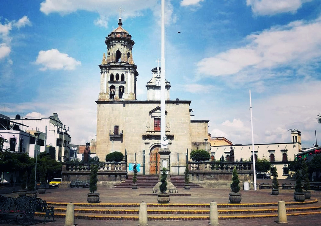
In the centre stands the parish church of Nuestra Señora del Rosario, with its neoclassical façade; its festival falls two Sundays after 7 October, with a novena, dances, horse races and a fireworks castillo. Local food means birria and barbacoa de borrego.
How to get to Zapotlanejo
Drive from Guadalajara: 30 min, 32 km
Zapotlanejo is about 34 km from Guadalajara, 40 minutes to an hour by car depending on traffic. Leave the city on Avenida Lázaro Cárdenas, past the Chapala highway and the Nueva Central Camionera, and follow free federal highway 80 for about 12 km to the signed turn-off; there is also a toll motorway between Guadalajara and Zapotlanejo, and the 80D toll road towards Tepatitlán and Lagos de Moreno starts near town. From the Lake Chapala area, take the Periférico Sur at the airport, which joins the free Guadalajara–Zapotlanejo road. Suburban buses run from Guadalajara; in 2022 the fare was about 38 pesos on the free road and 60 pesos on the toll road. The nearest Pueblo Mágico is Tlaquepaque, about 25 km away (roughly 30 minutes).
Directions to Zapotlanejo on Google Maps
Distances are in a straight line; the road is usually longer.
Links open a partner site. We may earn a commission if you book, at no cost to you.
From the nearest cities to Zapotlanejo
- Guadalajara · 32 km by road, 30 min
- Tepatitlán · 49 km by road, 40 min
- Ocotlán · 61 km by road, 50 min
Drive times by road from OpenStreetMap, without traffic or stops. Times marked ~ are estimated from the straight-line distance.
Before you go to Zapotlanejo: hours, prices and tips
- Hours
- Macro Tianguis del Vestir: Fridays, Saturdays and Sundays, 9:00–16:00. Tus Buenas Noticias · checked Oct 2026
- Best season
- Festival of Nuestra Señora del Rosario, two Sundays after 7 October, with a novena, dances, horse races and a fireworks castillo. INAFED, Enciclopedia de los Municipios de México · checked Oct 2026
- What to bring
- Cash: many clothes shops do not take cards. The Guadalajara Reporter · checked Oct 2026
Hours and prices change, especially around holidays. Each fact links to where we checked it.
Visiting Zapotlanejo: what to see and do
The more than 2,000 clothes shops along the main street and downtown.
The Macro Tianguis del Vestir in the Macroplaza (Friday to Sunday, 9:00–16:00).
The Puente de Calderón (1670–1672) and the Hidalgo monument, 7 km along the road to Tepatitlán.
The parish church of Nuestra Señora del Rosario and the iron bandstand on the main square.
El Garitón, the tower of the old customs post, at Hidalgo and Nicolás Bravo.
The Juan Terríquez monument, a 12 m stone relief by Ramón Villalobos.
Plan your trip
Places to stay in Zapotlanejo
Compare hotels, posadas, and rentals in and around Zapotlanejo.
Tours & activities
Day trips around Tlaquepaque sometimes stop in Zapotlanejo; a tour is the easy way to see it without a car.
Rental cars
Pick up a car at GDL (Guadalajara): about 26 min by road to Tlaquepaque, then 25 km more to Zapotlanejo, on your own schedule.
Flights
The nearest airport with scheduled flights is Guadalajara (GDL), about 26 min by road from Tlaquepaque, the base for Zapotlanejo.
Mobile data
Signal can drop away from Tlaquepaque: download a map of the way to Zapotlanejo before you set out, or carry an eSIM with data.
Links open a partner site. We may earn a commission if you book, at no cost to you.
When to go to Zapotlanejo mild
Zapotlanejo shares the climate of Tlaquepaque, 25 km away. The best months to visit are January, March, November, and December.
See the month-by-month climate of Tlaquepaque
Weather in Zapotlanejo now and the next 7 days
Live forecast from Open-Meteo. Chance of rain is the day's highest.
The closest Pueblo Mágico: Tlaquepaque

Tlaquepaque is the Pueblo Mágico closest to Zapotlanejo, with places to stay, food, and more to see.
Also close to
- Ajijic · Jalisco · 41 km away
- Temacapulín · Jalisco · 73 km away
- Mazamitla · Jalisco · 79 km away
- Jiquilpan · Michoacán · 79 km away
Closest to Zapotlanejo
-
Puente Grande · Town · 11 km away
-
Matatlán · Village · 13 km away
-
Juanacatlán · Town · 16 km away
-
Tonalá · Town · 18 km away
-
El Refugio · Village · 21 km away
-
Zapotlán del Rey · Village · 23 km away
-
Acatic · Town · 24 km away
-
Atequiza · Town · 26 km away


Near Zapotlanejo


Drive times by road from OpenStreetMap, without traffic. Times marked ~ are estimated from the straight-line distance.
Location from OpenStreetMap. Written by Puebloteca.