
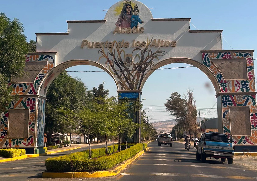
Town Acatic, Jalisco
The "Gateway to Los Altos": a town about 60 km from Guadalajara with its Candelaria church, birria and the Río Verde canyon nearby.
From Tepatitlán: 25 min by car (26 km by road) How to get there ↓
Near here
See everything nearby ↓



Plan your visit to Acatic
Where to stay near Acatic
Compare hotels, posadas and guest houses in Acatic.
Tours to Acatic
Day trips around Tlaquepaque sometimes stop in Acatic; a tour is the easy way to see it without a car.
 Tours from Guadalajara
Full Day Tour to Tequila and Amatitán with Fun and Culture
★ 4.9 (750) · From US$44
How to get to Acatic
- From Tepatitlán: about 25 min by road (~26 km)
- Nearest airport: Guadalajara (GDL), 26 min by car to Tlaquepaque
Links open a partner site. We may earn a commission if you book, at no cost to you.
Tours from Guadalajara, near Acatic


Tours, prices and ratings from Viator, checked weekly. We may earn a commission if you book.
About Acatic
Acatic is the seat of the municipality of the same name in the Altos Sur region of Jalisco, about 60 km from Guadalajara at 1,684 metres above sea level. It had 13,033 people at the 2020 census, a little over half of the municipality's population. It calls itself the "Gateway to Los Altos": the words are on the welcome arch at the entrance to town, crowned by the Virgin of Candelaria, and the municipal coat of arms carries two keys with the same meaning, because it is considered the western gateway to the Altos region. The name comes from Nahuatl and is read as "among the reeds".
The area was home to the Tecuexe and Caxcan peoples. Pedro Almíndez Chirino took possession of the place in 1531, its people rose against the Spanish in 1540 and joined the Mixtón War the next year, and in 1542 the town was named San Juan Bautista de Acatic. The main church was raised in the mid-16th century, dedicated to the Virgin of Candelaria in 1780 and rebuilt in 1904, as a plaque beside its main door records. Acatic became a municipality on 10 October 1820.
Today the economy rests on food manufacturing, which employs more than half of the municipality's insured workers, and on farming; more than 80% of the municipality's land is farmland, and the red of its soil is the main colour of the coat of arms. The big fiesta is 2 February, Candlemas, and on the following day people traditionally exchange gifts at home or in the main garden, called "mi Candelaria". Holy Week brings a living Way of the Cross through the streets. Local cooking means birria and barbacoa, with buñuelos, ate and cajeta for dessert, and crafts include drawn-thread embroidery, otate and reed baskets and stone molcajetes.
North of town the land drops into the canyons of the Verde and Santiago rivers, a protected natural area covering about 6% of the municipality. Down there are the Salto de Damián and Velo de Novia waterfalls and the thermal pools of Rancho El Venado.
How to get to Acatic
Drive from Tepatitlán: 25 min, 26 km
Acatic is about 60 km from Guadalajara, roughly 50 minutes by car: take the toll road to Zapotlanejo, then toll Highway 80D towards Lagos de Moreno; level with Acatic, a 4 km access road leads into town. From Tepatitlán it is about 24 km, a little over 20 minutes on the same toll road. There is no published direct route from Guadalajara's bus stations; by public transport, take a bus to Tepatitlán de Morelos from the Nueva Central Camionera (Coordinados, hourly, and Flecha Amarilla, about five a day, from Module 1), then a taxi to Acatic, about 26 minutes. To reach the Río Verde canyon, drive through town and take the turn-off past the municipal cemetery; the road down is rough, so a high-clearance pickup or 4x4 is advised.
Directions to Acatic on Google Maps
Distances are in a straight line; the road is usually longer.
Links open a partner site. We may earn a commission if you book, at no cost to you.
From the nearest cities to Acatic
- Tepatitlán · 26 km by road, 25 min
- Guadalajara · 58 km by road, 45 min
- Ocotlán · 86 km by road, 1 h 5 min
Drive times by road from OpenStreetMap, without traffic or stops. Times marked ~ are estimated from the straight-line distance.
Before you go to Acatic: hours, prices and tips
- Best time of day
- For the canyon waterfalls, July to October, when they carry the most water. México Desconocido · checked Oct 2026
- Best season
- Fiesta of the Virgin of Candelaria on 2 February, with the "mi Candelaria" gift exchange on 3 February; living Way of the Cross on Good Friday; Day of the Dead on 2 November at the municipal cemetery. Enciclopedia de los Municipios de México (INAFED) · checked Oct 2026
Hours and prices change, especially around holidays. Each fact links to where we checked it.
Visiting Acatic: what to see and do
Photograph the "Puerta de los Altos" arch at the entrance to town.
Step into the Candelaria church on the main square, founded in the 16th century and rebuilt in 1904.
Come on 2 February for the fiesta of the Virgin of Candelaria.
Eat birria or barbacoa, and take home buñuelos, ate or cajeta.
Go down into the Río Verde canyon to see the Salto de Damián, about 7 km northeast, and the Velo de Novia waterfall.
Soak in the thermal pools of Rancho El Venado in the same canyon.
Plan your trip
Places to stay in Acatic
Compare hotels, posadas, and rentals in and around Acatic.
Tours & activities
Day trips around Tlaquepaque sometimes stop in Acatic; a tour is the easy way to see it without a car.
Rental cars
Pick up a car at GDL (Guadalajara): about 26 min by road to Tlaquepaque, then 44 km more to Acatic, on your own schedule.
Flights
The nearest airport with scheduled flights is Guadalajara (GDL), about 26 min by road from Tlaquepaque, the base for Acatic.
Mobile data
Signal can drop away from Tlaquepaque: download a map of the way to Acatic before you set out, or carry an eSIM with data.
Links open a partner site. We may earn a commission if you book, at no cost to you.
When to go to Acatic mild
Acatic shares the climate of Tlaquepaque, 44 km away. The best months to visit are January, March, November, and December.
See the month-by-month climate of Tlaquepaque
Weather in Acatic now and the next 7 days
Live forecast from Open-Meteo. Chance of rain is the day's highest.
The closest Pueblo Mágico: Tlaquepaque

Tlaquepaque is the Pueblo Mágico closest to Acatic, with places to stay, food, and more to see.
Also close to
- Temacapulín · Jalisco · 50 km away
- Ajijic · Jalisco · 65 km away
- Nochistlán · Zacatecas · 65 km away
Closest to Acatic
-
El Refugio · Village · 6 km away
-
Tepatitlán de Morelos · City · 16 km away
-
Cuquío · Town · 20 km away
-
Teponahuasco · Village · 20 km away
-
Zapotlanejo · Town · 24 km away
-
Matatlán · Village · 26 km away
-
Pegueros · Village · 32 km away
-
Capilla de Guadalupe · Town · 34 km away


Near Acatic


Drive times by road from OpenStreetMap, without traffic. Times marked ~ are estimated from the straight-line distance.
Location from OpenStreetMap. Written by Puebloteca.