
City Tepatitlán de Morelos, Jalisco Municipality of Tepatitlán de Morelos
The largest city in the Altos de Jalisco, with a parish church of 63 m towers, the Señor de la Misericordia shrine and the April fair.
From Arandas: 55 min by car (56 km by road) How to get there ↓
Near here
See everything nearby ↓


Plan your visit to Tepatitlán de Morelos
Where to stay near Tepatitlán de Morelos
Compare hotels, posadas and guest houses in Tepatitlán de Morelos.
Tours to Tepatitlán de Morelos
Day trips and guided outings from Temacapulín often include Tepatitlán de Morelos; with a local guide you can get there without a car.
 Tours from Guadalajara
Full Day Tour to Tequila and Amatitán with Fun and Culture
★ 4.9 (751) · From US$44
How to get to Tepatitlán de Morelos
- From Arandas: about 55 min by road (~56 km)
- Nearest airport: Aguascalientes (AGU), 2 h 1 min by car to Temacapulín
Links open a partner site. We may earn a commission if you book, at no cost to you.
Tours from Guadalajara, near Tepatitlán de Morelos


Tours, prices and ratings from Viator, checked weekly. We may earn a commission if you book.
About Tepatitlán de Morelos
Tepatitlán de Morelos, "Tepa" to locals, is the seat of the municipality of the same name and the largest city in the Altos Sur region of Jalisco, at about 1,785 metres above sea level and some 70 km east of Guadalajara. At the 2020 census it had 98,842 people; in 1950 it had barely over 15,000. It is a farming powerhouse, considered Mexico's largest egg producer and the state's largest pork producer, and it also turns out milk and tequila. The Nahuatl name translates as "place of hard stone".
Before the Conquest the area belonged to the Tecuexe people. Captain Pedro Almíndez Chirinos arrived in 1530, sent by Nuño de Guzmán, and Franciscan friars built the first church, dedicated to Saint Francis of Assisi, which gave the colonial name San Francisco de Tecpatitlán. It became a villa in 1824 and in 1883 was made a city with Morelos added to its name. During the Cristero War (1927–1929) the bloodiest battle of the whole conflict was fought inside the town: the Cristeros fired from the tower of the San Antonio church and the federal troops from the towers of the parish church.
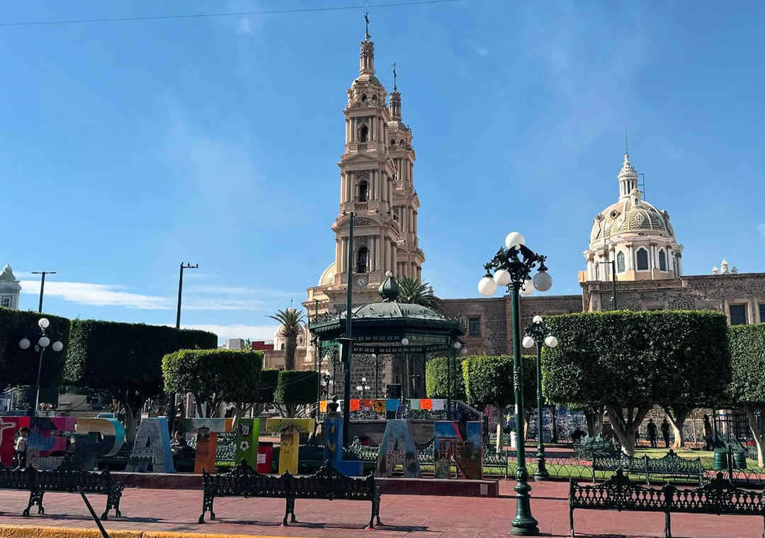
The parish church of San Francisco de Asís, built between 1742 and 1775, dominates the skyline with two 63-metre towers mixing Baroque and neoclassical styles; inside is a white Carrara marble altar by the Italian sculptor Augusto C. Volpi, flanked by statues of the four Evangelists. In front of it, the Plaza de Armas has an ironwork bandstand made in France. The pink-stone, neoclassical Sanctuary of the Señor de la Misericordia holds the most revered image in the region: tradition says that in 1835 a farmer, Pedro Medina, saw a light on Cerro Gordo and found a crucifix-like figure in an oak tree. An annexe displays more than 400 votive paintings, the oldest from 1840.
The big event is the April fair, known as Tepabril, in honour of the Señor de la Misericordia, with parades of floats, charreadas, a livestock show, concerts and a procession of the image through the streets. To the northwest, Cerro de la Campana is used for mountain biking, and the Río Verde canyon beside it for climbing and camping.
How to get to Tepatitlán de Morelos
Drive from Arandas: 55 min, 56 km
Tepatitlán is about 78 km from Guadalajara by road, roughly 55 minutes by car. The fast route is toll highway 80D, which starts near Zapotlanejo; the Tepatitlán exit joins free federal highway 80, and the Tepatitlán toll plaza is just past it. Federal 80 also runs here from Zapotlanejo without tolls. Buses from Guadalajara are run by Omnibus de Oriente (every 20 to 30 minutes, about 70 minutes), Coordinados and Flecha Amarilla, arriving at the Central de Autobuses de Tepatitlán, Calle Matamoros 750, on the south side of town. State highway 314 continues to Arandas. The nearest Pueblo Mágico is Temacapulín, about 42 km away (roughly 50 minutes).
Directions to Tepatitlán de Morelos on Google Maps
Distances are in a straight line; the road is usually longer.
Links open a partner site. We may earn a commission if you book, at no cost to you.
From the nearest cities to Tepatitlán de Morelos
- Arandas · 56 km by road, 55 min
- San Juan de los Lagos · 71 km by road, 55 min
- Guadalajara · 73 km by road, 1 h
Drive times by road from OpenStreetMap, without traffic or stops. Times marked ~ are estimated from the straight-line distance.
Before you go to Tepatitlán de Morelos: hours, prices and tips
- Best season
- April fair (Tepabril) in honour of the Señor de la Misericordia, in late April (from about 21 or 25 to 30 April), with floats, charreadas, a livestock show and concerts. Wikivoyage (Tepatitlán) · checked Oct 2026
Hours and prices change, especially around holidays. Each fact links to where we checked it.
Visiting Tepatitlán de Morelos: what to see and do
The parish church of San Francisco de Asís (1742–1775), with its 63 m towers and Carrara marble altar.
The French-made ironwork bandstand in the Plaza de Armas.
The Sanctuary of the Señor de la Misericordia, from 1852, and its museum of votive paintings.
The San Antonio church, scene of gunfights during the Cristero War.
The municipal palace, with a mural on the city's history, and the free City Museum.
The Mercado Centenario, with regional food on the upper floor.
Plan your trip
Places to stay in Tepatitlán de Morelos
Compare hotels, posadas, and rentals in and around Tepatitlán de Morelos.
Tours & activities
Day trips and guided outings from Temacapulín often include Tepatitlán de Morelos; with a local guide you can get there without a car.
Rental cars
Pick up a car at AGU (Aguascalientes): about 2 h 1 min by road to Temacapulín, then 42 km more to Tepatitlán de Morelos, on your own schedule.
Flights
The nearest airport with scheduled flights is Aguascalientes (AGU), about 2 h 1 min by road from Temacapulín, the base for Tepatitlán de Morelos.
Mobile data
Signal can drop away from Temacapulín: download a map of the way to Tepatitlán de Morelos before you set out, or carry an eSIM with data.
Links open a partner site. We may earn a commission if you book, at no cost to you.
When to go to Tepatitlán de Morelos mild
Tepatitlán de Morelos shares the climate of Temacapulín, 42 km away. The best months to visit are January, March, April, and November.
See the month-by-month climate of Temacapulín
Weather in Tepatitlán de Morelos now and the next 7 days
Live forecast from Open-Meteo. Chance of rain is the day's highest.
The closest Pueblo Mágico: Temacapulín

Temacapulín is the Pueblo Mágico closest to Tepatitlán de Morelos, with places to stay, food, and more to see.
Also close to
- Tlaquepaque · Jalisco · 61 km away
- Nochistlán · Zacatecas · 61 km away
- Ajijic · Jalisco · 77 km away
Closest to Tepatitlán de Morelos
-
Acatic · Town · 16 km away
-
Capilla de Guadalupe · Town · 17 km away
-
El Refugio · Village · 17 km away
-
Pegueros · Village · 18 km away
-
Valle de Guadalupe · Village · 26 km away
-
Mirandillas · Village · 27 km away
-
Cuquío · Town · 30 km away
-
Teponahuasco · Village · 31 km away

Near Tepatitlán de Morelos


Drive times by road from OpenStreetMap, without traffic. Times marked ~ are estimated from the straight-line distance.
Location from OpenStreetMap. Written by Puebloteca.