Town Poncitlán, Jalisco
Ciénega market town by the Santiago River, known for its Rosario parish and its picón bread, and the gateway to Mezcala on Lake Chapala.
From Ocotlán: 20 min by car (19 km by road) How to get there ↓
Near here
See everything nearby ↓


Plan your visit to Poncitlán
Where to stay near Poncitlán
Compare hotels, posadas and guest houses in Poncitlán.
Tours to Poncitlán
Day trips around Ajijic sometimes stop in Poncitlán; a tour is the easy way to see it without a car.
 Tours from Guadalajara
Full Day Tour to Tequila and Amatitán with Fun and Culture
★ 4.9 (751) · From US$44
How to get to Poncitlán
- From Ocotlán: about 20 min by road (~19 km)
- Nearest airport: Guadalajara (GDL), 39 min by car to Ajijic
Links open a partner site. We may earn a commission if you book, at no cost to you.
Tours from Guadalajara, near Poncitlán


Tours, prices and ratings from Viator, checked weekly. We may earn a commission if you book.
About Poncitlán
Poncitlán is the seat of the municipality of the same name, in Jalisco's Ciénega region, at 1,552 metres and right beside the Santiago River, which forms the municipality's northern boundary. It is part of the Ocotlán metropolitan area, and had 14,636 people at the 2020 census. To the south the municipality reaches Lake Chapala, where Mezcala and its island, San Pedro Itzicán and other lakeside villages lie.
The name has been explained as "place of cilacayotes" (a kind of squash), "beside the chilli fields on the shore" or "place of the god Ponze". The region belonged to Coca peoples within the lordship of Coinan, and in the early 16th century it was ruled by a chief named Ponze, whom the Spanish baptised Pedro Ponce. In 1510 the chief Chapalac left after a quarrel with him and went on to found what is now Chapala. Alonso de Ávalos conquered these lands in 1521 and Nuño de Guzmán arrived in 1530. Poncitlán already had a town council by 1825; in 1886 it lost municipal status and was annexed to Ocotlán, but it regained it on 21 February 1888.
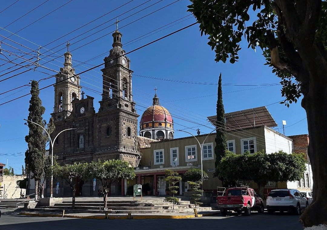
The first church, the convent of San Pedro y San Pablo, was built in 1543 and destroyed by an earthquake on 2 October 1847. The present parish of Nuestra Señora del Rosario was begun in 1868 on land donated by a resident; its dome was completed in 1920, with the four evangelists painted at its base. The image of the Virgin of the Rosary is held to be a gift from Charles V in 1548, and her fiesta, on the third Sunday of November, is the biggest of the year, with processions, dances, pilgrimages with flowers and banners, serenades and fireworks towers. Nearby is a 16th-century chapel that once served as a hospital for Indigenous people and holds a wooden Christ.
The local food star is picón, a sweet bread that the town's bakeries have made for generations, celebrated with its own Expo Picón in February. Poncitlán also makes natillas, long tostadas topped with potato, panela cheese and meat, lake charales, pozole and birria roasted with maguey leaves. Local crafts are huaraches, embroidery and weaving.
How to get to Poncitlán
Drive from Ocotlán: 20 min, 19 km
From Guadalajara head east on the road to Ocotlán; it is about 69 km and roughly 1 h to central Poncitlán. Ocotlán is about 18 km away, roughly 20 min, and Mezcala, on the lakeshore, about 17 km, roughly 20 min. From Ajijic, the nearest Pueblo Mágico, it is about 58 km by road, roughly 55 min.
By bus, Flecha Amarilla leaves hourly from Module 1 of Guadalajara's Nueva Central Camionera for Ocotlán (about 1 h 20 min); from Ocotlán continue by local bus or taxi to Poncitlán. For the lake side of the municipality, Chapala Plus runs hourly from the Antigua Central Camionera (Central Vieja) to Mezcala, taking about 1 h 30 min.
Directions to Poncitlán on Google Maps
Distances are in a straight line; the road is usually longer.
Links open a partner site. We may earn a commission if you book, at no cost to you.
From the nearest cities to Poncitlán
- Ocotlán · 19 km by road, 20 min
- Guadalajara · 67 km by road, 55 min
- Tepatitlán · 86 km by road, 1 h 10 min
Drive times by road from OpenStreetMap, without traffic or stops. Times marked ~ are estimated from the straight-line distance.
Before you go to Poncitlán: hours, prices and tips
- Best season
- Our Lady of the Rosary fiesta on the third Sunday of November; Expo Picón in February. El Ciudadano Jalisco / Vidal Turismo · checked Oct 2026
Hours and prices change, especially around holidays. Each fact links to where we checked it.
Visiting Poncitlán: what to see and do
The parish of Nuestra Señora del Rosario, with its 1920 dome and the Virgin said to be a gift from Charles V.
The 16th-century chapel that was once a hospital for Indigenous people, with its wooden Christ.
Plaza Miguel Hidalgo, facing the town hall, with its bandstand.
Picón and natillas from the town bakeries; the Expo Picón is held in February.
The Virgin of the Rosary fiesta on the third Sunday of November.
Cerro de Chiquihuitillo, with carved monoliths and petroglyphs, and Mezcala Island in the lake.
Plan your trip
Places to stay in Poncitlán
Compare hotels, posadas, and rentals in and around Poncitlán.
Tours & activities
Day trips around Ajijic sometimes stop in Poncitlán; a tour is the easy way to see it without a car.
Rental cars
Pick up a car at GDL (Guadalajara): about 39 min by road to Ajijic, then 36 km more to Poncitlán, on your own schedule.
Flights
The nearest airport with scheduled flights is Guadalajara (GDL), about 39 min by road from Ajijic, the base for Poncitlán.
Mobile data
Signal can drop away from Ajijic: download a map of the way to Poncitlán before you set out, or carry an eSIM with data.
Links open a partner site. We may earn a commission if you book, at no cost to you.
When to go to Poncitlán mild
Poncitlán shares the climate of Ajijic, 36 km away. The best months to visit are January, March, April, and November.
See the month-by-month climate of Ajijic
Weather in Poncitlán now and the next 7 days
Live forecast from Open-Meteo. Chance of rain is the day's highest.
The closest Pueblo Mágico: Ajijic

Ajijic is the Pueblo Mágico closest to Poncitlán, with places to stay, food, and more to see.
Also close to
- Jiquilpan · Michoacán · 48 km away
- Tlaquepaque · Jalisco · 50 km away
- Mazamitla · Jalisco · 53 km away
- Cotija · Michoacán · 67 km away
Closest to Poncitlán
-
Zapotlán del Rey · Village · 10 km away
-
Isla de Mezcala · Landmark · 14 km away
-
Otatlán · Village · 14 km away
-
Ocotlán · City · 17 km away
-
Atotonilquillo · Town · 21 km away
-
Atequiza · Town · 22 km away
-
Lago de Chapala · Lake · 22 km away
-
Jamay · Town · 24 km away


Near Poncitlán


Drive times by road from OpenStreetMap, without traffic. Times marked ~ are estimated from the straight-line distance.
Location from OpenStreetMap. Written by Puebloteca.