

Town San Andrés Huayápam, Oaxaca Central Valleys of Oaxaca
A hillside town just northeast of Oaxaca city, home of tejate, the cacao and corn drink, and of a yearly Feria del Tejate.
From Oaxaca: 15 min by car (12 km by road) How to get there ↓
Near here


Plan your visit to San Andrés Huayápam
Where to stay near San Andrés Huayápam
Compare hotels, posadas and guest houses in San Andrés Huayápam.
Tours to San Andrés Huayápam
Day trips around Capulálpam de Méndez sometimes stop in San Andrés Huayápam; a tour is the easy way to see it without a car.
 Tours from Oaxaca City
Hierve el Agua 2.5 hours, Mitla, Tule, Rugs and Mezcal for a Day
★ 4.9 (1,558) · From US$70
How to get to San Andrés Huayápam
- From Oaxaca: about 15 min by road (~12 km)
- Nearest airport: Oaxaca (OAX), 1 h 27 min by car to Capulálpam de Méndez
Links open a partner site. We may earn a commission if you book, at no cost to you.
Tours from Oaxaca City, near San Andrés Huayápam


Tours, prices and ratings from Viator, checked weekly. We may earn a commission if you book.
About San Andrés Huayápam
San Andrés Huayápam is a small town at the foot of the Sierra de San Felipe, about 8 km northeast of central Oaxaca city in a straight line and roughly half an hour away by road. It sits at about 1,710 m and is the seat of a small municipality of the Centro district; the town had 5,699 inhabitants in 2020, up from 527 in 1900, as the city has grown towards it. The name is of Nahuatl origin. Little of its early history is documented: the oldest recorded fact is that its land titles were issued in 1725. Part of the Parque Nacional Benito Juárez lies within the municipality, and the Huayápam stream, which comes down from the park, helps supply the city with water.
Huayápam is best known as the home of tejate, a cold, frothy drink of pre-Hispanic origin made from maize, cacao, toasted mamey seed (pixtle) and the rosita de cacao flower, traditionally served in a gourd cup (jícara). Women from the town have long carried tejate to sell in Oaxaca's markets every day. Around 120 tejateras, aged from teenagers to women in their eighties, belong to the Güie Bdie organization, named after the flower in Zapotec, which looks after the traditional recipe and ingredients; members agree to keep their own recipes private.
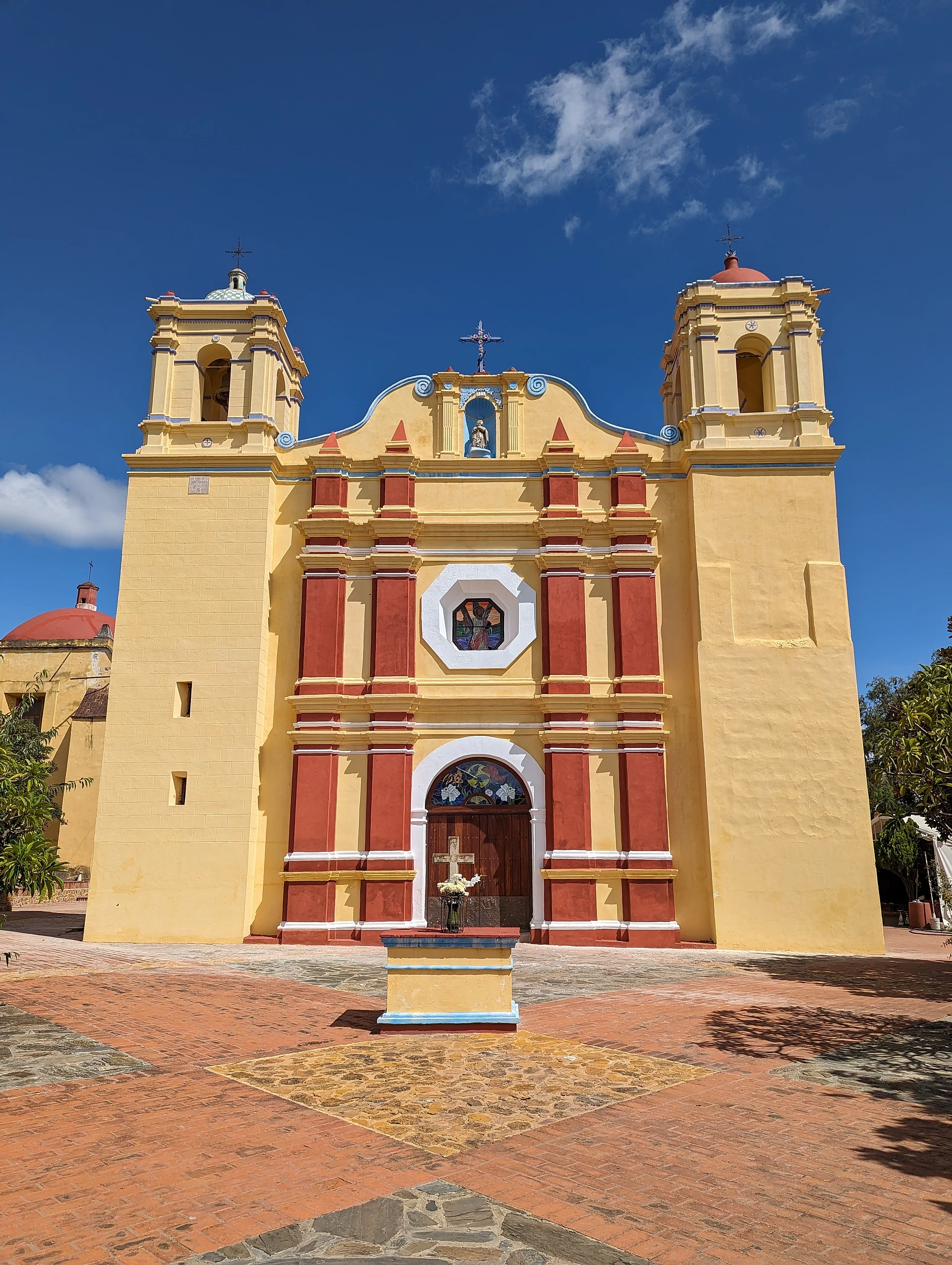
Since 2000 the town has held a Feria del Tejate each spring, with more than 80 producers serving their versions; in 2026 it fell on 29 March, Palm Sunday. The patron saint, San Andrés, is celebrated on 30 November with masses, processions, a calenda, dances and fireworks. On the hills above the town are small dams (presas) and a community eco-park, and the church of San Andrés stands at the centre of the village.
How to get to San Andrés Huayápam
Drive from Oaxaca: 15 min, 12 km
Huayápam lies on the northeastern edge of the Oaxaca urban area, about 8 km in a straight line from the Zócalo and roughly half an hour by taxi or car depending on traffic. Taxis from the city centre are the simplest option; the town is small enough to explore on foot.
Directions to San Andrés Huayápam on Google Maps
Distances are in a straight line; the road is usually longer.
Links open a partner site. We may earn a commission if you book, at no cost to you.
From the nearest cities to San Andrés Huayápam
- Oaxaca · 12 km by road, 15 min
- Tuxtepec · about 160 km by road, ~2 h 25 min
- Huajuapan de León · 179 km by road, 2 h 30 min
Drive times by road from OpenStreetMap, without traffic or stops. Times marked ~ are estimated from the straight-line distance.
What to see in San Andrés Huayápam 1
Sights with their own page, closest to the centre first.
-
Parque Nacional Benito Juárez · Nature reserve · 3 km from the centre
A national park of pine-oak forest on the hills just north of Oaxaca city, with marked trails, birdwatching, zip lines and views over the valley.
Map of San Andrés Huayápam
Neighbourhoods and villages of San Andrés Huayápam
Part of San Andrés Huayápam or just outside it, closest first.
-
San Francisco Tutla · Town · 4 km from the centre
Brick-making village in the Central Valleys right beside Oaxaca city, founded by settlers from San Sebastián Tutla; fair from late September. -
Tlalixtac de Cabrera · Town · 4 km from the centre
An old Zapotec farming town 10 km east of Oaxaca city, at the foot of the Sierra Norte, linked to the colonial painter Miguel Cabrera.
Day trips and tours from San Andrés Huayápam
The closest Pueblos Mágicos and places to visit, with the drive from San Andrés Huayápam and tours that leave from it.


Times marked ~ are estimated from the distance. Links open a partner site. We may earn a commission if you book, at no cost to you.
Before you go: getting to and around San Andrés Huayápam
- The nearest airport is Oaxaca (OAX).
- The best months to go are January, February, March, and December.
- 2 of the places on this page are more than 3 km from the centre: take a taxi, a ride-hailing app or a local bus.
- For day trips a rental car gives the most freedom; the tours above leave from San Andrés Huayápam.
Before you go to San Andrés Huayápam: hours, prices and tips
- Best season
- Feria del Tejate each spring (29 March in 2026); fiesta of San Andrés on 30 November. Visit Mexico; EcuRed · checked Oct 2026
Hours and prices change, especially around holidays. Each fact links to where we checked it.
Visiting San Andrés Huayápam: what to see and do
Drink tejate made by the town's tejateras.
Come to the Feria del Tejate in spring.
Visit the church of San Andrés in the town centre.
Walk up to the dams and the eco-park above the town.
Come on 30 November for the fiesta of San Andrés.
Continue uphill into the Parque Nacional Benito Juárez.
Plan your trip
Places to stay in San Andrés Huayápam
Compare hotels, posadas, and rentals in and around San Andrés Huayápam.
Tours & activities
Day trips around Capulálpam de Méndez sometimes stop in San Andrés Huayápam; a tour is the easy way to see it without a car.
Rental cars
Pick up a car at OAX (Oaxaca): about 1 h 27 min by road to Capulálpam de Méndez, then 32 km more to San Andrés Huayápam, on your own schedule.
Flights
The nearest airport with scheduled flights is Oaxaca (OAX), about 1 h 27 min by road from Capulálpam de Méndez, the base for San Andrés Huayápam.
Mobile data
Signal can drop away from Capulálpam de Méndez: download a map of the way to San Andrés Huayápam before you set out, or carry an eSIM with data.
Links open a partner site. We may earn a commission if you book, at no cost to you.
Photos
When to go to San Andrés Huayápam cool
San Andrés Huayápam shares the climate of Capulálpam de Méndez, 32 km away. The best months to visit are January, February, March, and December.
See the month-by-month climate of Capulálpam de Méndez
Weather in San Andrés Huayápam now and the next 7 days
Live forecast from Open-Meteo. Chance of rain is the day's highest.
The closest Pueblo Mágico: Capulálpam de Méndez

Capulálpam de Méndez is the Pueblo Mágico closest to San Andrés Huayápam, with places to stay, food, and more to see.
Also close to
- Mitla · Oaxaca · 38 km away
Near San Andrés Huayápam


Drive times by road from OpenStreetMap, without traffic. Times marked ~ are estimated from the straight-line distance.
Location from OpenStreetMap. Written by Puebloteca.