

Landmark Oaxaca de Juárez, Oaxaca Municipality of Oaxaca de Juárez Central Valleys of Oaxaca
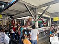
Oaxaca's huge wholesale market, a 21-hectare maze of produce, chiles, mole, pottery and food stalls; Saturday is the big day.
From Huajuapan de León: 2 h 20 min by car (170 km by road) How to get there ↓
Near here
See everything nearby ↓


Plan your visit to Central de Abastos
Where to stay near Central de Abastos
Compare hotels, posadas and guest houses in Central de Abastos.
Tours to Central de Abastos
Look for tours of the area around Capulálpam de Méndez that stop at Central de Abastos.
 Oaxaca Central de Abastos Market Food Tour
★ 4.8 (6) · From US$77
How to get to Central de Abastos
- From Huajuapan de León: about 2 h 20 min by road (~170 km)
- Nearest airport: Oaxaca (OAX), 1 h 27 min by car to Capulálpam de Méndez
Links open a partner site. We may earn a commission if you book, at no cost to you.
Popular tours to Central de Abastos


Tours, prices and ratings from Viator, checked weekly. We may earn a commission if you book.
About Central de Abastos
The Central de Abastos, officially the Mercado de Abasto "Margarita Maza de Juárez", is the biggest market in the state of Oaxaca and its main wholesale hub. It spreads over about 21 hectares on the southwest side of the city, across the Periférico from the historic centre and roughly a kilometre from the Zócalo, next to the second-class bus terminal. The state government calls it the largest and most important commercial centre in Oaxaca, and more than 20,000 people work there every day.
Planning began in 1970 and the land was expropriated in the mid-1970s; the market was built to move the street vendors who crowded the blocks around the Benito Juárez and 20 de Noviembre markets in the centro. It started with four covered halls (naves) and has kept growing. A study of its cultural life counted traders from 17 Oaxacan peoples speaking Spanish and six Indigenous languages, with Zapotec the most common. In 2023 the federal, state and city governments signed a plan with dozens of vendor organisations to rebuild the food and bread section and improve security, lighting and services, the first major works in some 40 years.
Inside it is a sprawling, noisy maze of aisles: fruit and vegetables by the crate, dried chiles and herbs, mole and chocolate pastes, meat, flowers, household goods, clothing, pottery and crafts. It is also where colectivos and shared taxis leave for the towns of the Valles Centrales. Food stalls feed the traders, and one of them, Doña Vale's memelas stand on the south side, became known after it appeared on Netflix's Street Food: Latin America. Saturday is the traditional main market day, when it is busiest. The crowds draw pickpockets, so keep valuables close.
How to get to Central de Abastos
Drive from Huajuapan de León: 2 h 20 min, 170 km
The market lies about 1 km southwest of the Zócalo, just across the Periférico and opposite the second-class bus terminal: a 15 to 20 minute walk from the centro, or a short taxi ride. Many city buses run to it, and shared taxis and colectivos to the Valles Centrales towns leave from stands on the Periférico at the market's edge.
Directions to Central de Abastos on Google Maps
Distances are in a straight line; the road is usually longer.
Links open a partner site. We may earn a commission if you book, at no cost to you.
From the nearest cities to Central de Abastos
- Huajuapan de León · 170 km by road, 2 h 20 min
- Tehuacán · 213 km by road, 2 h 25 min
- Tuxtepec · about 170 km by road, ~2 h 30 min
Drive times by road from OpenStreetMap, without traffic or stops. Times marked ~ are estimated from the straight-line distance.
Before you go to Central de Abastos: hours, prices and tips
- Hours
- Open daily, roughly 7am to 8pm; some stalls close on holidays. Salt & Wind · checked Oct 2026
- Best season
- Saturday is the main market day and the busiest; Tuesday and Friday are also lively. Planeta.com · checked Oct 2026
- What to bring
- Cash in small bills; vendors rarely have change and do not take cards. Chef Travel Guide · checked Oct 2026
- Rules
- It is huge and crowded, especially on Saturdays: watch out for pickpockets. Wikivoyage · checked Oct 2026
Hours and prices change, especially around holidays. Each fact links to where we checked it.
Visiting Central de Abastos: what to see and do
Go on a Saturday morning to see the market at its busiest.
Buy dried chiles, herbs, mole paste and chocolate in bulk.
Have memelas with salsa morita at Doña Vale's stall on the south side.
Look for local pottery and crafts among the household goods.
Catch a colectivo from here to Ocotlán, Zaachila or the Etla valley towns.
Plan your trip
Places to stay in Central de Abastos
Compare hotels, posadas, and rentals in and around Central de Abastos.
Tours & activities
Look for tours of the area around Capulálpam de Méndez that stop at Central de Abastos.
Rental cars
Pick up a car at OAX (Oaxaca): about 1 h 27 min by road to Capulálpam de Méndez, then 40 km more to Central de Abastos, on your own schedule.
Flights
The nearest airport with scheduled flights is Oaxaca (OAX), about 1 h 27 min by road from Capulálpam de Méndez, the base for Central de Abastos.
Mobile data
Signal can drop away from Capulálpam de Méndez: download a map of the way to Central de Abastos before you set out, or carry an eSIM with data.
Links open a partner site. We may earn a commission if you book, at no cost to you.
Photos
When to go to Central de Abastos cool
Central de Abastos shares the climate of Capulálpam de Méndez, 40 km away. The best months to visit are January, February, March, and December.
See the month-by-month climate of Capulálpam de Méndez
Weather in Central de Abastos now and the next 7 days
Live forecast from Open-Meteo. Chance of rain is the day's highest.
The closest Pueblo Mágico: Capulálpam de Méndez

Capulálpam de Méndez is the Pueblo Mágico closest to Central de Abastos, with places to stay, food, and more to see.
Also close to
- Mitla · Oaxaca · 42 km away
Closest to Central de Abastos
-
Andador Macedonio Alcalá · Landmark · 1 km away
-
Basílica de Nuestra Señora de la Soledad · Landmark · 1 km away
-
Cerro del Fortín · Viewpoint · 1 km away
-
Mercado 20 de Noviembre · Landmark · 1 km away
-
Mercado Benito Juárez · Landmark · 1 km away
-
Museo Textil de Oaxaca · Landmark · 1 km away
-
Museo de Arte Prehispánico de México Rufino Tamayo · Landmark · 1 km away
-
Oaxaca de Juárez · City · 1 km away

Near Central de Abastos



Drive times by road from OpenStreetMap, without traffic. Times marked ~ are estimated from the straight-line distance.
Location from OpenStreetMap. Written by Puebloteca.