
A region of Oaxaca
The three valleys that meet at the city of Oaxaca, about 1,500 m up between the Sierra Norte and the Sierra Sur: Etla to the north-west, Tlacolula to the east and Zimatlán–Ocotlán to the south. Zapotec cities grew here for more than two thousand years, so the valleys hold Monte Albán, Mitla, Yagul and Dainzú, colonial churches in almost every town, weekly markets, craft villages known for rugs, black pottery and carved alebrijes, and the mezcal country around Santiago Matatlán.
1 Pueblo Mágico · 85 places to visit
Pueblos Mágicos in Central Valleys of Oaxaca

Map
Places to visit in Central Valleys of Oaxaca 85
85 places with their own page, grouped by kind.
Towns · 55 Landmarks and museums · 15 Archaeological sites · 6 Villages · 5 Nature reserves · 2 Cities · 1 Viewpoints · 1
Towns
-
Cuilápam de Guerrero · Town · Oaxaca
A valley town 10 km southwest of Oaxaca, home to a vast, never-finished 16th-century Dominican basilica where Vicente Guerrero was shot in 1831. -
Eloxochitlán de Flores Magón · Town · Oaxaca
Mazatec town at 1,345 m in Oaxaca's far north, birthplace of the revolutionary Ricardo Flores Magón, a few kilometres from Huautla. -
Ocotlán de Morelos · Town · Oaxaca
Valley market town 35 km south of Oaxaca, with a big Friday market, a Dominican church restored by painter Rodolfo Morales and the Aguilar potters. -
Reyes Etla · Town · Oaxaca
Seat of a small Etla valley municipality at 1,635 m, 18 km from Oaxaca, beside the Señor de las Peñas sanctuary and its fifth-Friday-of-Lent pilgrimage. -
Rojas de Cuauhtémoc · Town · Oaxaca
Seat of its own municipality in the Central Valleys, about 19 km from Oaxaca City, with horse stables, open pasture and the rocky peak of El Yarit. -
San Agustín Etla · Town · Oaxaca
A hill town above the Etla valley with the CaSa arts centre in an 1883 textile mill, a walk along an old aqueduct and a famous Muerteada. -
San Andrés Huayápam · Town · Oaxaca
A hillside town just northeast of Oaxaca city, home of tejate, the cacao and corn drink, and of a yearly Feria del Tejate. -
San Andrés Zabache · Town · Oaxaca
Tiny municipality at the south end of the Central Valleys near Ejutla de Crespo: 748 people, 1,430 m, and the San Andrés fiesta on 30 November. -
San Andrés Zautla · Town · Oaxaca
Etla valley town with a 17th-century church and a working pipe organ dated 1726. -
San Antonino Castillo Velasco · Town · Oaxaca
Zapotec town next to Ocotlán, famous for silk-embroidered blouses and dresses and for figures made of dried immortelle flowers. -
San Antonio de la Cal · Town · Oaxaca
Central Valleys town next to Oaxaca city, settled by lime burners; fiesta of San Antonio Abad every 17 January and a name for tlayudas. -
San Baltazar Chichicápam · Town · Oaxaca
Mezcal town in the Ocotlán district at 1,553 m, with family palenques, a reservoir and the bitter river that gives it its name. -
San Baltazar Guelavila · Town · Oaxaca
Zapotec community in the hills above Mitla, with mezcal palenques and Las Salinas, a canyon of pools and salt springs. -
San Bartolo Coyotepec · Town · Oaxaca
The Zapotec town of barro negro, Oaxaca's shiny black pottery, 11 km south of the city, with Doña Rosa's workshop and the state folk art museum. -
San Bartolomé Quialana · Town · Oaxaca
Zapotec town at 1,803 m in the Tlacolula valley: hand-woven belts, the women's everyday dress and the New Year's Day climb up El Calvario hill. -
San Dionisio Ocotepec · Town · Oaxaca
A Zapotec-speaking town in the hills south of Matatlán, full of small family palenques making espadín and wild-agave mezcal. -
San Francisco Tutla · Town · Oaxaca
Brick-making village in the Central Valleys right beside Oaxaca city, founded by settlers from San Sebastián Tutla; fair from late September. -
San Jacinto Amilpas · Town · Oaxaca
Urban municipality hugging Oaxaca City at 1,600 m, from 861 people in 1940 to nearly 17,000 now. Church of 1800 and a fiesta on 17 August. -
San Juan Bautista la Raya · Town · Oaxaca
Town beside Oaxaca's airport on the Atoyac River, known for its Diablos carnival. -
San Juan Chilateca · Town · Oaxaca
Central Valleys town at 1,500 m where women hand-embroider dresses and three wind bands play. -
San Juan Guelavía · Town · Oaxaca
Zapotec town in the Central Valleys beside Highway 190, known for river-reed baskets and its annual Feria del Carrizo. -
San Juan de los Cués · Town · Oaxaca
Seat in Oaxaca's Cañada region at 862 m on highway 135, with a lemon fair held since 1979. -
San Marcos Tlapazola · Town · Mitla
A Zapotec village in the hills where women shape red clay pottery by hand, without a wheel, as their families have for generations. -
San Martín Tilcajete · Town · Oaxaca
Zapotec village 23 km south of Oaxaca where families carve and paint alebrijes, the bright copal-wood creatures, in workshops open to visitors. -
San Miguel Ixcatlán · Town · Oaxaca
Mixtec hamlet of 171 people at 1,674 m, 8 km from Santiago Yosondúa, set among green ravines of the sierra. -
San Nicolás Quialana · Town · Oaxaca
Valles Centrales village 2 km from Zimatlán, with the shell of an old hacienda now used as a school. -
San Pablo Etla · Town · Oaxaca
Town in the Etla valley a few minutes from Oaxaca city, founded in 1686 and now home to over 4,000 people. -
San Pablo Huitzo · Town · Oaxaca
Farming town at the head of the Etla valley with a 16th-century Dominican church, and site of the Zapotec Tomb 10 found in 2025. -
San Pablo Huixtepec · Town · Oaxaca
Valles Centrales town in the Zimatlán district with almost 10,000 people and a red-and-white church tower. -
San Sebastián Sedas · Town · Oaxaca
Hill village at nearly 2,000 m where a railway once ended; the track lies under earth and the last 3 km are a dirt road. -
San Sebastián Teitipac · Town · Oaxaca
Zapotec town in the Central Valleys at 1,604 m: red-quarry-stone church, hand-carved metates and molcajetes, tejate made on a metate. -
Santa Ana Zegache · Town · Oaxaca
Zapotec village in the Central Valleys at 1,500 m, with a church whose facade was repainted under Rodolfo Morales. -
Santa Ana del Valle · Town · Mitla
A Zapotec weaving village with a pioneering community museum and a church full of colonial saints. -
Santa Catarina Albarradas · Town · Oaxaca
Zapotec village of about 360 people at 1,650 m in the hills northeast of Mitla, with its sanctuary of San Antonio de Padua. -
Santa Catarina Minas · Town · Oaxaca
A small valley town near Ocotlán whose family palenques still double-distil mezcal in clay pots, the style known as minero. -
Santa Cruz Mixtepec · Town · Oaxaca
Mountain town south of Zimatlán at 1,580 m, with a church dating from 1557, a cave with rock paintings, bathing spots and mezcal agave. -
Santa Cruz Papalutla · Town · Oaxaca
Central Valleys town at 1,585 m, founded in 1615, where people weave carrizo-cane baskets and cages and the Santa Cruz church stands at the entrance. -
Santa Cruz Xoxocotlán · Town · Oaxaca
Oaxaca city's southern neighbour, famous for the candlelit Day of the Dead vigils in its old and new cemeteries on the night of 31 October. -
Santa Inés Yatzeche · Town · Oaxaca
Zapotec village of 908 people at 1,455 m on the Atoyac in the Valle Grande; the ruins of its old church stand on a mound. -
Santa Lucía del Camino · Town · Oaxaca
City 3 km east of Oaxaca, with 45,895 people in 2020 and the second-highest density of any municipality in the state. -
Santa María Atzompa · Town · Oaxaca
A potters' town 5 km northwest of Oaxaca, famous for jade-green glazed cookware, with a communal crafts market and family workshops. -
Santa María Pápalo · Town · Oaxaca
Cuicatec village above 2,000 m in the Cañada sierra, among forested hills and Volcán Prieto; its church was raised through communal tequio work. -
Santa María la Asunción · Town · Oaxaca
Mazatec town hugging Huautla at 1,668 m: embroidered huipiles, rabbit and mushroom dishes, and the Son Mazateco from its brass band. -
Santiago Etla · Town · Oaxaca
Municipal agency of San Lorenzo Cacaotepec at 1,596 m, a short drive from Oaxaca city, with a Friday market and a July fair for Santiago. -
Santiago Matatlán · Town · Mitla
A town that calls itself the world capital of mezcal, lined with family palenques where you can see agave being roasted and distilled. -
Santiago Suchilquitongo · Town · Oaxaca
Etla valley town below Huijazoo, the hilltop Zapotec site of the painted Tomb 5; its community museum shows a replica of the tomb. -
Santos Reyes Pápalo · Town · Oaxaca
Cuicatec town at 2,104 m in the Sierra de Flores Magón; "place of butterflies", known for red clay pottery and embroidery. -
Soledad Etla · Town · Oaxaca
Municipal seat in the Etla valley at 1,590 m, with an 1721 church, about 19 km from Oaxaca city and frequent shared transport. -
Teotitlán del Valle · Town · Mitla
The Zapotec weaving village of the valley: family workshops making wool rugs on foot looms with natural dyes. -
Tlacolula · Town · Mitla
Home of one of Oaxaca's oldest and biggest Sunday markets, and a Baroque chapel covered in gilded plasterwork. -
Tlalixtac de Cabrera · Town · Oaxaca
An old Zapotec farming town 10 km east of Oaxaca city, at the foot of the Sierra Norte, linked to the colonial painter Miguel Cabrera. -
Villa de Etla · Town · Oaxaca
Etla valley market town with a 1636 Dominican church and a Wednesday market known for quesillo, tamales and goat barbacoa. -
Villa de Zaachila · Town · Oaxaca
The last Zapotec capital, 15 km south of Oaxaca, with a big Thursday market and Mixtec tombs beside the church of La Natividad. -
Zimatlán de Álvarez · Town · Oaxaca
Seat of Zimatlán municipality in the Central Valleys at 1,496 m; founded in 1558, with a kiosk plaza and an 1910 iron market. -
Ánimas Trujano · Town · Oaxaca
Town on Oaxaca city's southern edge with a listed 19th-century church, a wind band and a Danza de la Pluma; main feast on 12 December.










Landmarks and museums
-
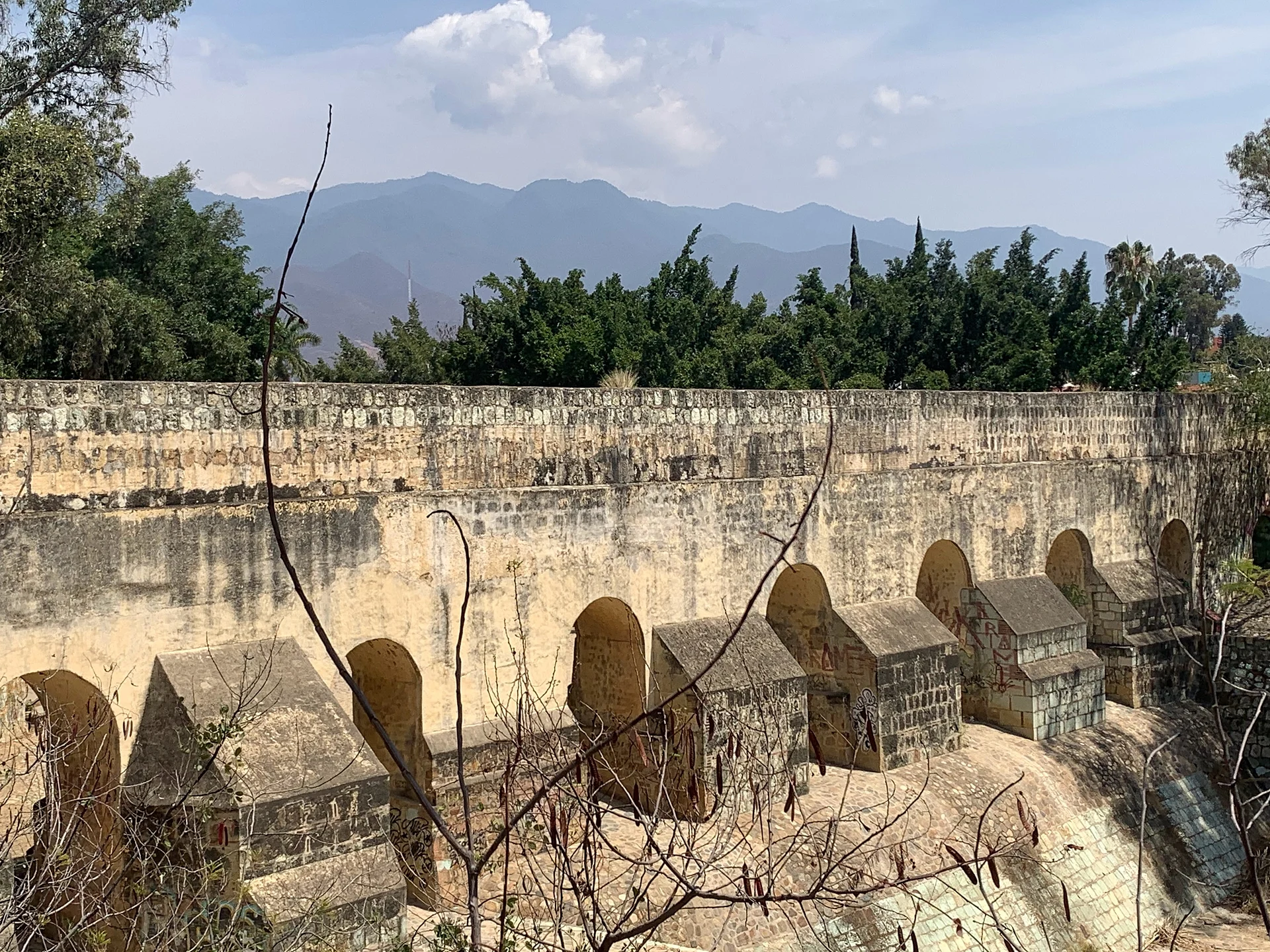
Acueducto de San Felipe del Agua · Landmark · Oaxaca
Oaxaca's 18th-century stone and brick aqueduct, best seen where its tall arches leap the Jalatlaco ravine at La Cascada in Xochimilco. -
Andador Macedonio Alcalá · Landmark · Oaxaca
Oaxaca's green-stone pedestrian street, car-free since 1985, running five blocks from the Zócalo to Santo Domingo past museums and galleries. -
Barrio de Jalatlaco · Landmark · Oaxaca
Oaxaca's first Barrio Mágico: cobbled lanes, adobe and cantera houses, street murals and the 18th-century church of San Matías. -
Barrio de Xochimilco · Landmark · Oaxaca
Oaxaca's old Nahua-founded barrio north of the centre: aqueduct arches with doorways beneath them, pedal looms, a weekend organic market. -
Basílica de Nuestra Señora de la Soledad · Landmark · Oaxaca
The 17th-century baroque basilica of Oaxaca's patron Virgin, with a screen-like stone facade, a 1686 organ and nieve stands in the plaza. -
Central de Abastos · Landmark · Oaxaca
Oaxaca's huge wholesale market, a 21-hectare maze of produce, chiles, mole, pottery and food stalls; Saturday is the big day. -
Jardín Etnobotánico de Oaxaca · Landmark · Oaxaca
A 2.3-hectare garden of plants native to Oaxaca on Santo Domingo's old convent orchard, famous for its columnar-cactus walls; guided tours only. -
Mercado 20 de Noviembre · Landmark · Oaxaca
Oaxaca's food market, two blocks south of the Zócalo: mole, tlayudas, pan de yema with chocolate and the smoky Pasillo de Humo grill aisle. -
Mercado Benito Juárez · Landmark · Oaxaca
Oaxaca's oldest covered market, an 1894 iron hall a block from the Zócalo selling mole, quesillo, chocolate, crafts and fresh juice. -
Museo Textil de Oaxaca · Landmark · Oaxaca
Free textile museum in an 18th-century cochineal merchant's house in Oaxaca's centro, with rotating shows of huipiles, rebozos and dyes. -
Museo de Arte Prehispánico de México Rufino Tamayo · Landmark · Oaxaca
Painter Rufino Tamayo's gift to his home city: about 1,350 pre-Hispanic pieces shown as art in five rooms painted in his own palette. -
Templo de Santo Domingo de Guzmán · Landmark · Oaxaca
Oaxaca's grandest Baroque church, with a gilded interior and a former Dominican convent that now holds the Museo de las Culturas and Monte Albán's Tomb 7 gold. -
Tlacochahuaya · Landmark · Mitla
A Dominican church whose walls and vaults are painted with flowers and angels, with a restored 18th-century pipe organ. -
Zócalo de Oaxaca · Landmark · Oaxaca
Oaxaca's shady, car-free main square, laid out in 1529, with an art nouveau bandstand, café arcades, the cathedral and the Alameda de León beside it. -
Árbol del Tule · Landmark · Mitla
A Montezuma cypress in Santa María del Tule with one of the widest trunks in the world, on the road between Oaxaca and Mitla.


Archaeological sites
-
Dainzú · Archaeological site · Mitla
An early Zapotec site at the foot of a hill, famous for dozens of carved stones showing masked ball players. -
Lambityeco · Archaeological site · Mitla
A small Zapotec site by the highway with two striking stucco masks of Cocijo, the rain god, at a noble's house. -
Monte Albán · Archaeological site · Oaxaca
The Zapotec capital on a levelled mountaintop 400 m above Oaxaca's valleys, founded about 500 BC and a UNESCO World Heritage Site since 1987. -
San José Mogote · Archaeological site · Oaxaca
The Etla valley's first large Zapotec village, older than Monte Albán, with a restored mound and a small community museum. -
Yagul · Archaeological site · Mitla
A Zapotec hilltop city with a big ball court, a maze-like palace and a fortress lookout over the Tlacolula Valley. -
Zona Arqueológica de Atzompa · Archaeological site · Oaxaca
Monte Albán's hilltop satellite city above Santa María Atzompa, with the largest ball court in the Monte Albán area and free entry.


Villages
-
San Antonio Arrazola · Village · Oaxaca
The village below Monte Albán's west slope where Manuel Jiménez began carving painted wooden animals, the roots of Oaxaca's alebrijes. -
San Isidro Roaguía · Village · Oaxaca
The small village beside Hierve el Agua that runs the site's mineral pools, stalls and cabins, high above the valleys east of Mitla. -
San Pedro y San Pablo Ayutla · Village · Oaxaca
Mixe highland town at about 2,000 m, seat of the Prelature of Mixes, with two wind bands, an eight-day Day of the Dead and views of Zempoaltépetl. -
Santa María Tlahuitoltepec · Village · Oaxaca
Mixe seat at 2,239 m in the Sierra Norte, known for its music school (CECAM, since 1977) and its brass bands. -
Santo Tomás Jalieza · Village · Oaxaca
Zapotec weaving village on the Ocotlán road, where women sell backstrap-loom belts, bags and table runners at a cooperative market.


Nature reserves
-
Hierve el Agua · Nature reserve · Mitla
Mineral springs that have built white rock "waterfalls" down a cliff, with pools to swim in and huge views of the sierra. -
Parque Nacional Benito Juárez · Nature reserve · Oaxaca
A national park of pine-oak forest on the hills just north of Oaxaca city, with marked trails, birdwatching, zip lines and views over the valley.


Cities
-
Oaxaca de Juárez · City · Oaxaca
Oaxaca's capital: a green-stone colonial centre on UNESCO's list with Monte Albán, famous for moles, markets, mezcal and the July Guelaguetza.

Viewpoints
-
Cerro del Fortín · Viewpoint · Oaxaca
The hill over Oaxaca City: stairs up to the Guelaguetza auditorium, a Juárez statue with city views, a planetarium and forest trails.
Top tours in Central Valleys of Oaxaca


Tours, prices and ratings from Viator, checked weekly. We may earn a commission if you book.
Getting around Central Valleys of Oaxaca
Fly into Oaxaca (OAX).
Cities to start from: Oaxaca
Most of the region is reached by road: a rental car is the easiest way to see several places in a day, and buses link the larger towns.
When to visit Central Valleys of Oaxaca
Most of Central Valleys of Oaxaca is at its best in January, February, March, and December.
Month-by-month climate on each Pueblo Mágico's page: Mitla