
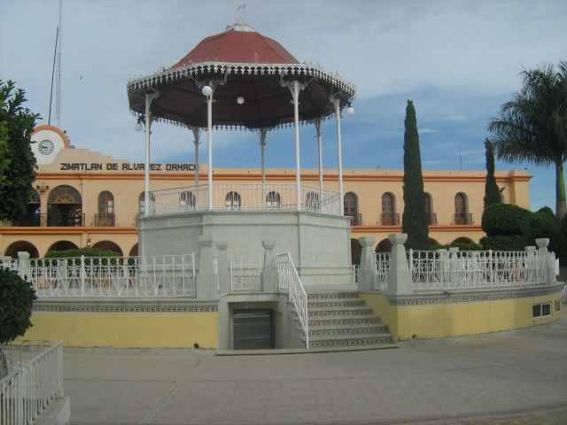
Town Zimatlán de Álvarez, Oaxaca Central Valleys of Oaxaca
Seat of Zimatlán municipality in the Central Valleys at 1,496 m; founded in 1558, with a kiosk plaza and an 1910 iron market.
From Oaxaca: 25 min by car (23 km by road) How to get there ↓
Near here
See everything nearby ↓


Plan your visit to Zimatlán de Álvarez
Where to stay near Zimatlán de Álvarez
Compare hotels, posadas and guest houses in Zimatlán de Álvarez.
Tours to Zimatlán de Álvarez
Day trips around Mitla sometimes stop in Zimatlán de Álvarez; a tour is the easy way to see it without a car.
How to get to Zimatlán de Álvarez
- From Oaxaca: about 25 min by road (~23 km)
- Nearest airport: Oaxaca (OAX), 47 min by car to Mitla
Links open a partner site. We may earn a commission if you book, at no cost to you.
About Zimatlán de Álvarez
Zimatlán de Álvarez is the seat of the municipality of Zimatlán, not of Ciénega de Zimatlán, which is a separate neighbouring municipality. It lies in the Central Valleys at about 1,496 m and had 14,226 residents in 2020. The name comes from Nahuatl and means "place of roots"; Álvarez honours the independence figure Juan N. Álvarez. In Zapotec it was called Guihuio and earlier Tepetcimatlan.
Tradition says the town was founded in 1558 on the initiative of Bishop Fray Bernardo de Alburquerque. In 1868 a decree renamed it Villa Álvarez and granted an annual five-day fair, 18 to 23 January. The central plaza has a kiosk, a monument to Porfirio Díaz from 1910, fountains and the stepped churchyard; the iron market was imported from England in 1910. The earthquakes of 1931 and 1999 damaged the cemetery chapel, the market and the municipal palace.
Trade was strong until trucks arrived in 1925; today the economy mixes farming, commerce and services, and remittances count for a great deal. Local food includes barbacoa de borrego, cooked underground, and handmade tortillas. The area once had a branch of the Teruel railway, and the road was later built along that route to join the Ocotlán highway. The climate is much like Oaxaca city's.
How to get to Zimatlán de Álvarez
Drive from Oaxaca: 25 min, 23 km
Zimatlán is about 22 km in a straight line from Oaxaca city (the draft estimates 25 minutes; by road allow about 30 to 40 minutes, approximate), south through the valley, the same direction the paved road runs toward Villa Sola de Vega and the coast. The town centre has a second-class bus station, and colectivos and taxis link with other municipalities of the district; we found no published timetables or operator names, so ask at Oaxaca's second-class terminals. The capital's first-class terminal is on Calzada Niños Héroes de Chapultepec (Wikivoyage). Mitla, the draft's nearby pueblo, is about 44 km away in a straight line, roughly 50 minutes.
Directions to Zimatlán de Álvarez on Google Maps
Distances are in a straight line; the road is usually longer.
Links open a partner site. We may earn a commission if you book, at no cost to you.
From the nearest cities to Zimatlán de Álvarez
- Oaxaca · 23 km by road, 25 min
- Huajuapan de León · 193 km by road, 2 h 45 min
- Tehuacán · 235 km by road, 2 h 50 min
Drive times by road from OpenStreetMap, without traffic or stops. Times marked ~ are estimated from the straight-line distance.
Before you go to Zimatlán de Álvarez: hours, prices and tips
- Best time of day
- An annual fair runs 18 to 23 January; it was first granted by a decree of 1868. Wikipedia · checked Oct 2026
Hours and prices change, especially around holidays. Each fact links to where we checked it.
Visiting Zimatlán de Álvarez: what to see and do
Stroll the plaza with its kiosk and the municipal palace.
Step into the church of San Lorenzo and climb the churchyard steps.
See the iron market imported from England in 1910.
Eat barbacoa de borrego and handmade tortillas.
Come 18 to 23 January for the fair.
Plan your trip
Places to stay in Zimatlán de Álvarez
Compare hotels, posadas, and rentals in and around Zimatlán de Álvarez.
Tours & activities
Day trips around Mitla sometimes stop in Zimatlán de Álvarez; a tour is the easy way to see it without a car.
Rental cars
Pick up a car at OAX (Oaxaca): about 47 min by road to Mitla, then 44 km more to Zimatlán de Álvarez, on your own schedule.
Flights
The nearest airport with scheduled flights is Oaxaca (OAX), about 47 min by road from Mitla, the base for Zimatlán de Álvarez.
Mobile data
Signal can drop away from Mitla: download a map of the way to Zimatlán de Álvarez before you set out, or carry an eSIM with data.
Links open a partner site. We may earn a commission if you book, at no cost to you.
When to go to Zimatlán de Álvarez mild
Zimatlán de Álvarez shares the climate of Mitla, 44 km away. The best months to visit are January, February, March, and December.
See the month-by-month climate of Mitla
Weather in Zimatlán de Álvarez now and the next 7 days
Live forecast from Open-Meteo. Chance of rain is the day's highest.
The closest Pueblo Mágico: Mitla

Mitla is the Pueblo Mágico closest to Zimatlán de Álvarez, with places to stay, food, and more to see.
Also close to
- Capulálpam de Méndez · Oaxaca · 59 km away
Closest to Zimatlán de Álvarez
-
San Nicolás Quialana · Town · 2 km away
-
San Pablo Huixtepec · Town · 6 km away
-
Santa Ana Zegache · Town · 7 km away
-
Santa Inés Yatzeche · Town · 7 km away
-
San Martín Tilcajete · Town · 9 km away
-
Villa de Zaachila · Town · 10 km away
-
Santo Tomás Jalieza · Village · 12 km away
-
San Antonino Castillo Velasco · Town · 13 km away


Near Zimatlán de Álvarez






Drive times by road from OpenStreetMap, without traffic. Times marked ~ are estimated from the straight-line distance.
Location from OpenStreetMap. Written by Puebloteca.