

City Oaxaca de Juárez, Oaxaca Municipality of Oaxaca de Juárez Central Valleys of Oaxaca
Oaxaca's capital: a green-stone colonial centre on UNESCO's list with Monte Albán, famous for moles, markets, mezcal and the July Guelaguetza.
From Huajuapan de León: 2 h 20 min by car (170 km by road) How to get there ↓
Near here


Plan your visit to Oaxaca de Juárez
Where to stay near Oaxaca de Juárez
Compare hotels, posadas and guest houses in Oaxaca de Juárez.
Tours to Oaxaca de Juárez
Day trips and guided outings from Capulálpam de Méndez often include Oaxaca de Juárez; with a local guide you can get there without a car.
 Tours from Oaxaca City
Hierve el Agua 2.5 hours, Mitla, Tule, Rugs and Mezcal for a Day
★ 4.9 (1,558) · From US$70
How to get to Oaxaca de Juárez
- From Huajuapan de León: about 2 h 20 min by road (~170 km)
- Nearest airport: Oaxaca (OAX), 1 h 27 min by car to Capulálpam de Méndez
Links open a partner site. We may earn a commission if you book, at no cost to you.
Tours from Oaxaca City, near Oaxaca de Juárez


Tours, prices and ratings from Viator, checked weekly. We may earn a commission if you book.
About Oaxaca de Juárez
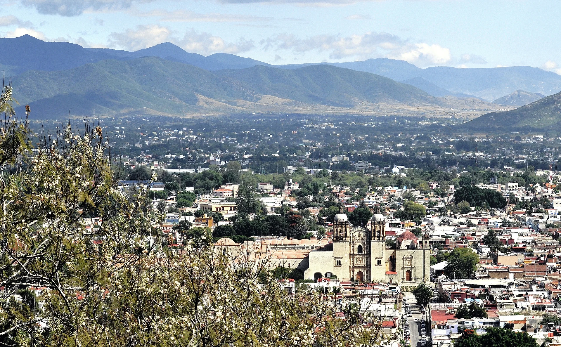
Oaxaca de Juárez, usually just called Oaxaca, is the capital of the state of the same name and the main city of the Valles Centrales. It sits at about 1,555 m above sea level in the Central Valleys, at the foot of the Cerro del Fortín, and is roughly 490 km southeast of Mexico City by toll highway. The 2020 census counted 258,913 people in the city itself and about 714,000 in the metropolitan area, which spreads into a ring of neighbouring municipalities.
People lived in this valley for thousands of years before the city existed. From around 500 BC the Zapotecs ruled it from Monte Albán, the hilltop capital about 9 km west of today's centre, and later Zapotec and Mixtec lords contested the valley. Aztec troops set up a garrison here in the 1480s and called the spot Huaxyacac, "at the tip of the huaje" (a tree common in the valleys), which became the name Oaxaca. The Spanish arrived in 1521, organised a villa named Antequera in the late 1520s, and in 1532 Charles V gave it the rank of city. It took the surname "de Juárez" in 1872 to honour Benito Juárez, the Zapotec-born president of Mexico, who had studied in the city and served as state governor.
The old centre is a grid of low, thick-walled houses and churches built from the local green cantera stone, which earned the city the nickname la Verde Antequera; repeated earthquakes, which brought down church towers more than once, explain the heavy walls. In 1987 UNESCO listed the historic centre together with the archaeological site of Monte Albán as World Heritage. The Zócalo, with the cathedral and the Alameda de León beside it, is the hub; from there the pedestrian Andador Macedonio Alcalá runs north to the church and former convent of Santo Domingo, now home to the Museo de las Culturas de Oaxaca and the Jardín Etnobotánico. Other stops include the Basílica de la Soledad, the Rufino Tamayo pre-Hispanic art museum, the Museo Textil and the Instituto de Artes Gráficas founded by the painter Francisco Toledo.
Oaxaca is one of Mexico's great food cities. Its kitchens are known for the moles (negro, colorado, verde, amarillo and more), tlayudas, tasajo and cecina, chapulines (toasted grasshoppers), quesillo, pan de yema and hot chocolate ground with almonds and cinnamon, and the state is the heartland of mezcal. The Benito Juárez and 20 de Noviembre markets sit a block or two south of the Zócalo, and the huge Central de Abastos lies across the ring road to the southwest.
The calendar is full. The Guelaguetza takes over July: on the two Mondays after July 16 (the Lunes del Cerro) delegations from the state's regions dance at the open-air Guelaguetza Auditorium on the Cerro del Fortín, which seats about 11,000 people, with parades and concerts in town around them. For Day of the Dead, from late October to November 2, the city fills with comparsas (costumed street parades with bands), sand carpets in the Zócalo and the Plaza de la Danza, and night vigils in the cemeteries. On December 23 the Noche de Rábanos fills the Zócalo with scenes carved from giant radishes, a contest the city has held every year since 1897.
How to get to Oaxaca de Juárez
Drive from Huajuapan de León: 2 h 20 min, 170 km
By air: Oaxaca's Xoxocotlán International Airport (OAX) is about 7–8 km south of the centre, 20–30 minutes by road, with frequent flights from Mexico City and a few nonstops from the US (Dallas, Houston). From the airport there are fixed-fare taxis sold at booths past arrivals and shared colectivo vans to the centro. By bus: ADO and other lines run from Mexico City's TAPO terminal in about 6.5 hours to the first-class bus station on Calzada Niños Héroes de Chapultepec, north of the centre. By car: the toll highway from Mexico City via Puebla is about 490 km. Since 2024 a new highway links the city with Puerto Escondido on the coast in about 3 hours.
Directions to Oaxaca de Juárez on Google Maps
Distances are in a straight line; the road is usually longer.
Links open a partner site. We may earn a commission if you book, at no cost to you.
From the nearest cities to Oaxaca de Juárez
- Huajuapan de León · 170 km by road, 2 h 20 min
- Tuxtepec · about 170 km by road, ~2 h 30 min
- Tehuacán · 212 km by road, 2 h 30 min
Drive times by road from OpenStreetMap, without traffic or stops. Times marked ~ are estimated from the straight-line distance.
What to see in Oaxaca de Juárez 15
Sights with their own page, closest to the centre first.
Landmarks and museums
-
Andador Macedonio Alcalá · Landmark · in the centre
Oaxaca's green-stone pedestrian street, car-free since 1985, running five blocks from the Zócalo to Santo Domingo past museums and galleries. -
Mercado 20 de Noviembre · Landmark · in the centre
Oaxaca's food market, two blocks south of the Zócalo: mole, tlayudas, pan de yema with chocolate and the smoky Pasillo de Humo grill aisle. -
Mercado Benito Juárez · Landmark · in the centre
Oaxaca's oldest covered market, an 1894 iron hall a block from the Zócalo selling mole, quesillo, chocolate, crafts and fresh juice. -
Museo Textil de Oaxaca · Landmark · in the centre
Free textile museum in an 18th-century cochineal merchant's house in Oaxaca's centro, with rotating shows of huipiles, rebozos and dyes. -
Museo de Arte Prehispánico de México Rufino Tamayo · Landmark · in the centre
Painter Rufino Tamayo's gift to his home city: about 1,350 pre-Hispanic pieces shown as art in five rooms painted in his own palette. -
Zócalo de Oaxaca · Landmark · in the centre
Oaxaca's shady, car-free main square, laid out in 1529, with an art nouveau bandstand, café arcades, the cathedral and the Alameda de León beside it. -
Barrio de Jalatlaco · Landmark · 1 km from the centre
Oaxaca's first Barrio Mágico: cobbled lanes, adobe and cantera houses, street murals and the 18th-century church of San Matías. -
Barrio de Xochimilco · Landmark · 1 km from the centre
Oaxaca's old Nahua-founded barrio north of the centre: aqueduct arches with doorways beneath them, pedal looms, a weekend organic market. -
Basílica de Nuestra Señora de la Soledad · Landmark · 1 km from the centre
The 17th-century baroque basilica of Oaxaca's patron Virgin, with a screen-like stone facade, a 1686 organ and nieve stands in the plaza. -
Central de Abastos · Landmark · 1 km from the centre
Oaxaca's huge wholesale market, a 21-hectare maze of produce, chiles, mole, pottery and food stalls; Saturday is the big day. -
Jardín Etnobotánico de Oaxaca · Landmark · 1 km from the centre
A 2.3-hectare garden of plants native to Oaxaca on Santo Domingo's old convent orchard, famous for its columnar-cactus walls; guided tours only. -
Templo de Santo Domingo de Guzmán · Landmark · 1 km from the centre
Oaxaca's grandest Baroque church, with a gilded interior and a former Dominican convent that now holds the Museo de las Culturas and Monte Albán's Tomb 7 gold. -
Acueducto de San Felipe del Agua · Landmark · 2 km from the centre
Oaxaca's 18th-century stone and brick aqueduct, best seen where its tall arches leap the Jalatlaco ravine at La Cascada in Xochimilco.


Nature reserves
-
Parque Nacional Benito Juárez · Nature reserve · 6 km from the centre
A national park of pine-oak forest on the hills just north of Oaxaca city, with marked trails, birdwatching, zip lines and views over the valley.

Viewpoints
-
Cerro del Fortín · Viewpoint · 1 km from the centre
The hill over Oaxaca City: stairs up to the Guelaguetza auditorium, a Juárez statue with city views, a planetarium and forest trails.

Map of Oaxaca de Juárez
Neighbourhoods and villages of Oaxaca de Juárez
Part of Oaxaca de Juárez or just outside it, closest first.
-
Viguera · Town · 8 km from the centre
Locality in Oaxaca de Juárez at 1,622 m, north of the capital; it grew from 260 people in 1900 to 8,506 in 2020.
Day trips and tours from Oaxaca de Juárez
The closest Pueblos Mágicos and places to visit, with the drive from Oaxaca de Juárez and tours that leave from it.
Popular day trips from Oaxaca


Tours, prices and ratings from Viator, checked weekly. We may earn a commission if you book.


All 6 Pueblos Mágicos within a weekend of Oaxaca →
Times marked ~ are estimated from the distance. Links open a partner site. We may earn a commission if you book, at no cost to you.
Before you go: getting to and around Oaxaca de Juárez
- The nearest airport is Oaxaca (OAX).
- The best months to go are January, February, March, and December.
- 2 of the places on this page are more than 3 km from the centre: take a taxi, a ride-hailing app or a local bus.
- For day trips a rental car gives the most freedom; the tours above leave from Oaxaca de Juárez.
Before you go to Oaxaca de Juárez: hours, prices and tips
- Best season
- Dry season November to April (warm days, cool nights); rains May to October, heaviest June to September. July (Guelaguetza), Day of the Dead and Christmas are the busiest times. Wikivoyage · checked Oct 2026
- Guide or tour
- Guelaguetza 2026: Lunes del Cerro on July 20 and 27 at the Guelaguetza Auditorium (10:00 am and 5:00 pm shows); seats in Palcos A and B are sold on Superboletos from June, Palcos C and D are free. Por Esto · checked Oct 2026
- Rules
- Day of the Dead cemetery vigils are family gatherings: visit respectfully, ask before photographing people. Far Away Worlds · checked Oct 2026
Hours and prices change, especially around holidays. Each fact links to where we checked it.
Visiting Oaxaca de Juárez: what to see and do
Walk the pedestrian Andador Macedonio Alcalá from the Zócalo up to the church of Santo Domingo.
See the Tomb 7 treasure from Monte Albán in the Museo de las Culturas de Oaxaca, in Santo Domingo's former convent.
Take a guided tour of the Jardín Etnobotánico behind Santo Domingo.
Eat tlayudas, mole and grilled tasajo at the Benito Juárez and 20 de Noviembre markets.
Climb or drive to the Cerro del Fortín and the Guelaguetza Auditorium for a view over the valley.
Plan around the Guelaguetza (July), Day of the Dead (late October to November 2) or the Noche de Rábanos (December 23).
Day-trip to Monte Albán, about 9 km west of the centre.
Plan your trip
Places to stay in Oaxaca de Juárez
Compare hotels, posadas, and rentals in and around Oaxaca de Juárez.
Tours & activities
Day trips and guided outings from Capulálpam de Méndez often include Oaxaca de Juárez; with a local guide you can get there without a car.
Rental cars
Pick up a car at OAX (Oaxaca): about 1 h 27 min by road to Capulálpam de Méndez, then 40 km more to Oaxaca de Juárez, on your own schedule.
Flights
The nearest airport with scheduled flights is Oaxaca (OAX), about 1 h 27 min by road from Capulálpam de Méndez, the base for Oaxaca de Juárez.
Mobile data
Signal can drop away from Capulálpam de Méndez: download a map of the way to Oaxaca de Juárez before you set out, or carry an eSIM with data.
Links open a partner site. We may earn a commission if you book, at no cost to you.
Photos
When to go to Oaxaca de Juárez cool
Oaxaca de Juárez shares the climate of Capulálpam de Méndez, 40 km away. The best months to visit are January, February, March, and December.
See the month-by-month climate of Capulálpam de Méndez
Weather in Oaxaca de Juárez now and the next 7 days
Live forecast from Open-Meteo. Chance of rain is the day's highest.
The closest Pueblo Mágico: Capulálpam de Méndez

Capulálpam de Méndez is the Pueblo Mágico closest to Oaxaca de Juárez, with places to stay, food, and more to see.
Also close to
- Mitla · Oaxaca · 41 km away
Near Oaxaca de Juárez






Drive times by road from OpenStreetMap, without traffic. Times marked ~ are estimated from the straight-line distance.
Location from OpenStreetMap. Written by Puebloteca.