

City Othón P. Blanco, Quintana Roo Municipality of Othón P. Blanco Chetumal and the south
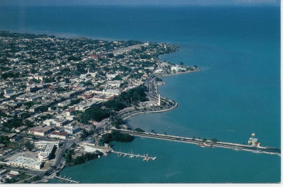
Quintana Roo's laid-back capital on Chetumal Bay: a long bayfront boulevard, the Maya Culture Museum and the gateway to Belize.
From Playa del Carmen: 4 h 15 min by car (318 km by road) How to get there ↓
Near here


Plan your visit to Chetumal
Where to stay near Chetumal
Compare hotels, posadas and guest houses in Chetumal.
Tours to Chetumal
Day trips and guided outings from Bacalar often include Chetumal; with a local guide you can get there without a car.
 Bacalar: Wild Calakmul As It Should Be | Climb, Hike & Bats
★ 5.0 (10) · From US$134
How to get to Chetumal
- From Playa del Carmen: about 4 h 15 min by road (~318 km)
- Nearest airport: Chetumal (CTM), 31 min by car to Bacalar
Links open a partner site. We may earn a commission if you book, at no cost to you.
Popular tours to Chetumal
Tours, prices and ratings from Viator, checked weekly. We may earn a commission if you book.
About Chetumal
Chetumal is the capital of Quintana Roo and the seat of Othón P. Blanco municipality, set on the western shore of Chetumal Bay close to where the Río Hondo meets the sea and marks the border with Belize. It lies roughly 388 km south of Cancún and about 45 minutes by bus from Bacalar. The 2020 census counted 169,028 people, which makes it the state's third city after Cancún and Playa del Carmen, yet it feels far more like a provincial government town than a resort.
The city began in 1898, when the naval officer Othón P. Blanco anchored a pontoon at the mouth of the Río Hondo to assert Mexican control over the border and the logging trade; the settlement was first called Payo Obispo and took the old Maya name of the region, Chetumal, in the 1930s. Early Payo Obispo was a town of raised, brightly painted wooden houses in the English-Caribbean style shared with Belize. Hurricane Janet flattened most of it in September 1955, killing around 500 people, and the city was rebuilt in concrete, though a handful of wooden houses survive. When Quintana Roo became a state in 1974, Chetumal became its capital.
Visitors mostly come for the bay. The Boulevard Bahía runs along the waterfront past the Monumento al Renacimiento, the fishermen's monument, the state Congress and the Explanada de la Bandera, and it is where the evening walkers, bars and the February carnival parades all end up. Avenida de los Héroes is the main commercial street, with the Museo de la Cultura Maya at its northern end and the Centro Cultural de las Bellas Artes, home to the city museum, further south. Beyond the centre, Calderitas and the Oxtankah ruins lie a short ride up the bay shore, and Bacalar, Kohunlich and Dzibanché are within day-trip distance.
Chetumal is also a practical hub: it has an international airport, a main ADO terminal on Avenida Insurgentes, a Tren Maya station, the land border to Belize at Subteniente López and a daily boat service to San Pedro and Caye Caulker. Expect heat all year (the wet season runs May to October) and prices noticeably lower than on the northern Riviera.
How to get to Chetumal
Drive from Playa del Carmen: 4 h 15 min, 318 km
By road Chetumal is about 388 km south of Cancún via Highway 307, which passes Tulum, Felipe Carrillo Puerto and Bacalar; from Mérida it is also about 388 km. ADO buses arrive at the main terminal on Avenida Insurgentes, about 4 km from the centre (taxi to the centre around M$25–30 in 2022); the direct bus from Cancún takes roughly 5.5 hours and the hop from Bacalar about 45 minutes. The Tren Maya stops at Chetumal, with only a few departures a day. Chetumal International Airport (CTM) has domestic flights. From Belize, buses and vans cross at Subteniente López, and the Belize Express water taxi runs daily from San Pedro and Caye Caulker to the Terminal Marítima.
Directions to Chetumal on Google Maps
Distances are in a straight line; the road is usually longer.
Links open a partner site. We may earn a commission if you book, at no cost to you.
From the nearest cities to Chetumal
- Playa del Carmen · 318 km by road, 4 h 15 min
- Valladolid · 304 km by road, 4 h 30 min
- Tizimín · 360 km by road, 5 h 20 min
Drive times by road from OpenStreetMap, without traffic or stops. Times marked ~ are estimated from the straight-line distance.
What to see in Chetumal 3
Sights with their own page, closest to the centre first.
Landmarks and museums
-
Centro Histórico de Chetumal · Landmark · 1 km from the centre
Mexico's first Barrio Mágico (November 2022): Payo Obispo's wooden houses, 1930s Art Deco buildings and the old market by the bay. -
Museo de la Cultura Maya · Landmark · 1 km from the centre
Chetumal's big museum of the Maya world, built around a three-level sacred ceiba, with city models and a recreated jungle.
Islands
-
Isla Tamalcab · Island · 16 km from the centre
Uninhabited wooded island in Chetumal Bay, reached by boat from Calderitas, home to spider monkeys, coatis and seabirds.
Map of Chetumal
Neighbourhoods and villages of Chetumal
Part of Chetumal or just outside it, closest first.
-
Calderitas · Village · 8 km from the centre
Fishing village on Chetumal Bay just north of the city, known for seafood restaurants, bay swimming spots and boats to Isla Tamalcab.
Day trips and tours from Chetumal
The closest Pueblos Mágicos and places to visit, with the drive from Chetumal and tours that leave from it.


Times marked ~ are estimated from the distance. Links open a partner site. We may earn a commission if you book, at no cost to you.
Before you go: getting to and around Chetumal
- The nearest airport is Chetumal (CTM).
- The best months to go are January, February, March, and December.
- 2 of the places on this page are more than 3 km from the centre: take a taxi, a ride-hailing app or a local bus.
- Isla Tamalcab: reached by boat or on foot, not by road (each page says from where).
- For day trips a rental car gives the most freedom; the tours above leave from Chetumal.
Before you go to Chetumal: hours, prices and tips
- Best season
- Carnival is held in February along the Boulevard Bahía, with free concerts at the Explanada de la Bandera (12–17 February in 2026). The wet season runs May to October; November to April is dry. Ruptura360 (2026); Wikipedia · checked Oct 2026
Hours and prices change, especially around holidays. Each fact links to where we checked it.
Visiting Chetumal: what to see and do
Walk the Boulevard Bahía along the bay at sunset, past the Monumento al Renacimiento and the manatee sculpture at the end of the malecón
Museo de la Cultura Maya on Avenida de los Héroes, with its three-level ceiba and city models
Centro Cultural de las Bellas Artes and the city museum, on the history of Payo Obispo
The scale model of wooden Payo Obispo and the surviving Caribbean-style wooden houses
Calderitas' seafood restaurants and the Oxtankah Maya ruins up the bay shore
Carnival parades along the Boulevard Bahía in February
Plan your trip
Places to stay in Chetumal
Compare hotels, posadas, and rentals in and around Chetumal.
Tours & activities
Day trips and guided outings from Bacalar often include Chetumal; with a local guide you can get there without a car.
Rental cars
Pick up a car at CTM (Chetumal): about 31 min by road to Bacalar, then 23 km more to Chetumal, on your own schedule.
Flights
The nearest airport with scheduled flights is Chetumal (CTM), about 31 min by road from Bacalar, the base for Chetumal.
Mobile data
Signal can drop away from Bacalar: download a map of the way to Chetumal before you set out, or carry an eSIM with data.
Links open a partner site. We may earn a commission if you book, at no cost to you.
Photos
When to go to Chetumal warm
Chetumal shares the climate of Bacalar, 23 km away. The best months to visit are January, February, March, and December.
See the month-by-month climate of Bacalar
Weather in Chetumal now and the next 7 days
Live forecast from Open-Meteo. Chance of rain is the day's highest.
The closest Pueblo Mágico: Bacalar

Bacalar is the Pueblo Mágico closest to Chetumal, with places to stay, food, and more to see.
Near Chetumal


Drive times by road from OpenStreetMap, without traffic. Times marked ~ are estimated from the straight-line distance.
Location from OpenStreetMap. Written by Puebloteca.