


Island Othón P. Blanco, Quintana Roo Municipality of Othón P. Blanco Chetumal and the south
Uninhabited wooded island in Chetumal Bay, reached by boat from Calderitas, home to spider monkeys, coatis and seabirds.
Reached by boat from Calderitas: 15 min each way. How to get there ↓
Near here
See everything nearby ↓


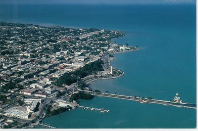

Plan your visit to Isla Tamalcab
Where to stay near Isla Tamalcab
Compare hotels, posadas and guest houses in Isla Tamalcab.
Tours to Isla Tamalcab
Day trips and guided outings from Bacalar often include Isla Tamalcab; with a local guide you can get there without a car.
 Tours from Bacalar
Sailing Tour through the Laguna de los Siete Colores
★ 5.0 (1,675) · From US$41
How to get to Isla Tamalcab
- Reached by boat from Calderitas: 15 min each way.
- From Chetumal: about 10 min by road (~9 km)
- Nearest airport: Chetumal (CTM), 31 min by car to Bacalar
Links open a partner site. We may earn a commission if you book, at no cost to you.
Tours from Bacalar, near Isla Tamalcab


Tours, prices and ratings from Viator, checked weekly. We may earn a commission if you book.
About Isla Tamalcab
Isla Tamalcab is a low, forested island in Chetumal Bay, lying about 8 km off the shore opposite Calderitas and visible as a long green line from the village waterfront. It covers about 2.4 km², rises no more than 10 m above the water and has no permanent residents. Its name is traditionally linked to the Nahuatl word for tamale, though the historian Martín Ramos Díaz has argued it is a corruption of the name of a Belizean logger, Tom Lac.
The island is covered in low flooded forest and medium-height jungle, with mangroves along the southern shore that act as a nursery for fish and birds. Spider monkeys, coatis, agoutis and pacas live on the island, and herons, frigatebirds, pelicans, cormorants and ospreys are common around it. The boat ride out often turns up dolphins and manatees in the bay, though sightings are never guaranteed. Small beaches and rocky patches of shore break up the mangrove edge rather than any long stretch of sand.
Tamalcab was part of the Maya coastal trade network of the eastern Yucatán Peninsula, serving as a waypoint and lookout. Around ten unrestored structures, mostly platforms and bases from the Postclassic period (about 900–1500 AD), remain in the forest. Visits are by hired boat or guided tour from Calderitas, typically combining a walk on the island's trails with wildlife spotting, kayaking or snorkelling in the shallows; there are no services on the island, so everything has to be brought along and taken back.
How to get to Isla Tamalcab
Drive from Chetumal to Calderitas: 10 min, 9 km
Go first to Calderitas, about 15 minutes by taxi or colectivo from central Chetumal (colectivos leave next to the Museo de la Cultura Maya). From the Calderitas pier, shared boats, private boats and guided tours cross to the island in about 10 to 20 minutes. Early morning usually has the calmest water.
Reached by boat from Calderitas: 15 min each way.
Directions to Isla Tamalcab on Google Maps
Distances are in a straight line; the road is usually longer.
Links open a partner site. We may earn a commission if you book, at no cost to you.
From the nearest cities to Isla Tamalcab
- Chetumal · 9 km by road, 10 min to Calderitas, then 15 min by boat
- Playa del Carmen · 325 km by road, 4 h 20 min to Calderitas, then 15 min by boat
- Valladolid · 311 km by road, 4 h 30 min to Calderitas, then 15 min by boat
Drive times by road from OpenStreetMap, without traffic or stops. Times marked ~ are estimated from the straight-line distance.
Before you go to Isla Tamalcab: hours, prices and tips
- Entry
- No entry fee for the island; the cost is the boat. Approximate prices: shared boat MX$300–500 per person, private boat MX$1,200–3,500 per group, full guided tour from MX$1,500 per person. México Desconocido · checked Oct 2026
- Best time of day
- November to April (dry season), setting out early in the morning when weather and water are calmer. Programa Destinos México · checked Oct 2026
- Guide or tour
- A boat is required; a guide is optional (shared boat, private boat or guided tour from Calderitas). Tours: Viator GetYourGuide México Desconocido · checked Oct 2026
- What to bring
- Plenty of water, biodegradable sunscreen, a hat, insect repellent and comfortable walking shoes. México Desconocido · checked Oct 2026
- Rules
- Do not take stones, plants or archaeological material; do not feed or disturb the animals; carry out all your rubbish. México Desconocido · checked Oct 2026
Hours and prices change, especially around holidays. Each fact links to where we checked it.
Visiting Isla Tamalcab: what to see and do
Watch for spider monkeys and coatis along the island's trails
Look for dolphins and manatees on the boat ride across the bay
Birdwatching around the southern mangroves: herons, frigatebirds, pelicans, ospreys
Unrestored Postclassic Maya platforms in the forest
Kayak, paddleboard or snorkel in the shallows
Plan your trip
Places to stay in Isla Tamalcab
Compare hotels, posadas, and rentals in and around Isla Tamalcab.
Tours & activities
Day trips and guided outings from Bacalar often include Isla Tamalcab; with a local guide you can get there without a car.
Rental cars
Pick up a car at CTM (Chetumal): about 31 min by road to Bacalar, then 22 km more to Isla Tamalcab, on your own schedule.
Flights
The nearest airport with scheduled flights is Chetumal (CTM), about 31 min by road from Bacalar, the base for Isla Tamalcab.
Mobile data
Signal can drop away from Bacalar: download a map of the way to Isla Tamalcab before you set out, or carry an eSIM with data.
Links open a partner site. We may earn a commission if you book, at no cost to you.
Photos
When to go to Isla Tamalcab warm
Isla Tamalcab shares the climate of Bacalar, 22 km away. The best months to visit are January, February, March, and December.
See the month-by-month climate of Bacalar
Weather in Isla Tamalcab now and the next 7 days
Live forecast from Open-Meteo. Chance of rain is the day's highest.
The closest Pueblo Mágico: Bacalar

Bacalar is the Pueblo Mágico closest to Isla Tamalcab, with places to stay, food, and more to see.
Closest to Isla Tamalcab
-
Oxtankah · Archaeological site · 4 km away
-
Calderitas · Village · 8 km away
-
Museo de la Cultura Maya · Landmark · 15 km away
-
Centro Histórico de Chetumal · Landmark · 16 km away
-
Chetumal · City · 16 km away
-
Canal de los Piratas · Lagoon · 20 km away
-
Laguna de Bacalar · Lagoon · 20 km away
-
Isla de los Pájaros · Island · 21 km away


Near Isla Tamalcab
-
Kohunlich · Archaeological site · Quintana Roo
1 h 25 min: 15 min by boat back to Calderitas, then drive -
Chacchoben · Archaeological site · Quintana Roo
1 h 40 min: 15 min by boat back to Calderitas, then drive -
Dzibanché · Archaeological site · Quintana Roo
1 h 50 min: 15 min by boat back to Calderitas, then drive -
Ichkabal · Archaeological site · Quintana Roo
1 h 55 min: 15 min by boat back to Calderitas, then drive


Drive times by road from OpenStreetMap, without traffic. Times marked ~ are estimated from the straight-line distance.
Lists with Isla Tamalcab
Islands in Quintana Roo · 4Location from OpenStreetMap. Written by Puebloteca.