City Centro, Tabasco Municipality of Centro
Tabasco's river capital, with the Olmec heads of Parque-Museo La Venta, a lagoon in the middle of town and an easy base for the Ruta del Cacao.
From Cárdenas: 45 min by car (52 km by road) How to get there ↓
Near here
See everything nearby ↓


Plan your visit to Villahermosa
Where to stay near Villahermosa
Compare hotels, posadas and guest houses in Villahermosa.
Tours to Villahermosa
Day trips and guided outings from Teapa often include Villahermosa; with a local guide you can get there without a car.
 Palenque Archaeological site from Villahermosa City or airport
★ 5.0 (9) · From US$184
How to get to Villahermosa
- From Cárdenas: about 45 min by road (~52 km)
- Nearest airport: Villahermosa (VSA), 1 h 5 min by car to Teapa
Links open a partner site. We may earn a commission if you book, at no cost to you.
Popular tours to Villahermosa


Tours, prices and ratings from Viator, checked weekly. We may earn a commission if you book.
About Villahermosa
Villahermosa is the capital of Tabasco and its largest city, the seat of the municipality of Centro, with about 340,000 people in the city itself and more than 800,000 in the metropolitan area (2020 census). It sits only about ten meters above sea level on low ground ringed by water: the Grijalva River runs along its east side, the Carrizal to the north and west, and several lagoons lie inside the city, the largest being the Laguna de las Ilusiones, now a protected area.
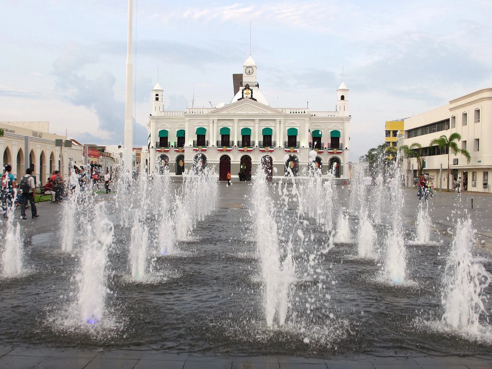
The Spanish founded the town on 24 June 1564, the feast of Saint John the Baptist, and for centuries it was called San Juan Bautista. In 1598 Philip II gave it the title Villa Hermosa de San Juan Bautista, and in 1916 Governor Francisco J. Múgica dropped the saint's name and left plain Villahermosa. The old center still has the Plaza de Armas with the Palacio de Gobierno, finished in 1894, the Inmaculada Concepción church known as La Conchita, and the Zona Luz, a grid of pedestrian streets with shops, cafés and the tiled Casa de los Azulejos museum. From the 1950s on, oil money turned the city into the business hub of Pemex in the southeast, and the modern Tabasco 2000 district grew up to the west.
For visitors the big draws are cultural. Parque-Museo La Venta, set up by the poet Carlos Pellicer in 1958 beside the Laguna de las Ilusiones, displays Olmec colossal heads and altars in a patch of tropical forest, and the Museo Regional de Antropología Carlos Pellicer Cámara holds Olmec, Maya and Zoque pieces. The city is also a practical base: Comalcalco and the cacao haciendas are about an hour away, Yumká is near the airport, and the Sierra towns and the Pantanos de Centla can be done as day trips. Expect heat and humidity most of the year; spring can pass 40 °C, and in 2007 the rivers flooded much of the city.
How to get to Villahermosa
Drive from Cárdenas: 45 min, 52 km
Villahermosa's Carlos Rovirosa Pérez international airport is about 15 km east of the city, with flights from Mexico City and other Mexican cities. By road it is about 900 km from Mexico City, 390 km from Campeche and 650 km from Mérida. First-class ADO buses use the main terminal, while the Central Camionera and the Cardesa terminal handle regional routes to Cárdenas, Comalcalco, Huimanguillo, Cunduacán and Palenque. Around town, shared and private taxis are common.
Directions to Villahermosa on Google Maps
Distances are in a straight line; the road is usually longer.
Links open a partner site. We may earn a commission if you book, at no cost to you.
From the nearest cities to Villahermosa
- Cárdenas · 52 km by road, 45 min
- Palenque · 143 km by road, 1 h 55 min
- Ciudad del Carmen · 176 km by road, 2 h 15 min
Drive times by road from OpenStreetMap, without traffic or stops. Times marked ~ are estimated from the straight-line distance.
Before you go to Villahermosa: hours, prices and tips
- Best season
- Hot and humid all year, with heavy summer and autumn rains. The Feria Tabasco runs in late April and early May, the city's patron saint and founding day is 24 June, and the carnival is held before Ash Wednesday. Wikipedia (es) · checked Oct 2026
- What to bring
- Light clothes, sunscreen and mosquito repellent, especially for Parque-Museo La Venta and Yumká. Wikivoyage · checked Oct 2026
Hours and prices change, especially around holidays. Each fact links to where we checked it.
Visiting Villahermosa: what to see and do
See the Olmec colossal heads among the trees at Parque-Museo La Venta.
Walk through 3,000 years of Tabasco's past at the Museo Regional de Antropología Carlos Pellicer Cámara.
Stroll the pedestrian streets of the Zona Luz and the Plaza de Armas with the Palacio de Gobierno.
Walk the lakeside paths of Parque Tomás Garrido Canabal on the Laguna de las Ilusiones.
Try pejelagarto, tamales de chipilín and a cold pozol, the local cacao and corn drink.
Plan your trip
Places to stay in Villahermosa
Compare hotels, posadas, and rentals in and around Villahermosa.
Tours & activities
Day trips and guided outings from Teapa often include Villahermosa; with a local guide you can get there without a car.
Rental cars
Pick up a car at VSA (Villahermosa): about 1 h 5 min by road to Teapa, then 49 km more to Villahermosa, on your own schedule.
Flights
The nearest airport with scheduled flights is Villahermosa (VSA), about 1 h 5 min by road from Teapa, the base for Villahermosa.
Mobile data
Signal can drop away from Teapa: download a map of the way to Villahermosa before you set out, or carry an eSIM with data.
Links open a partner site. We may earn a commission if you book, at no cost to you.
When to go to Villahermosa warm
Villahermosa shares the climate of Teapa, 49 km away. The best months to visit are January, February, March, and December.
See the month-by-month climate of Teapa
Weather in Villahermosa now and the next 7 days
Live forecast from Open-Meteo. Chance of rain is the day's highest.
The closest Pueblo Mágico: Teapa

Teapa is the Pueblo Mágico closest to Villahermosa, with places to stay, food, and more to see.
Also close to
- Tapijulapa · Tabasco · 61 km away
- Frontera · Tabasco · 67 km away
Closest to Villahermosa
-
Zona Luz · Landmark · 0 km away
-
Parque-Museo La Venta · Landmark · 2 km away
-
Comalcalco · Town · 44 km away
-
Comalcalco · Archaeological site · 44 km away
-
Tacotalpa · Town · 45 km away
-
Grutas de Coconá · Cave · 47 km away
-
El Azufre · Hot springs · 49 km away
Near Villahermosa


Drive times by road from OpenStreetMap, without traffic. Times marked ~ are estimated from the straight-line distance.
Location from OpenStreetMap. Written by Puebloteca.