Archaeological site Comalcalco, Tabasco Cacao Route
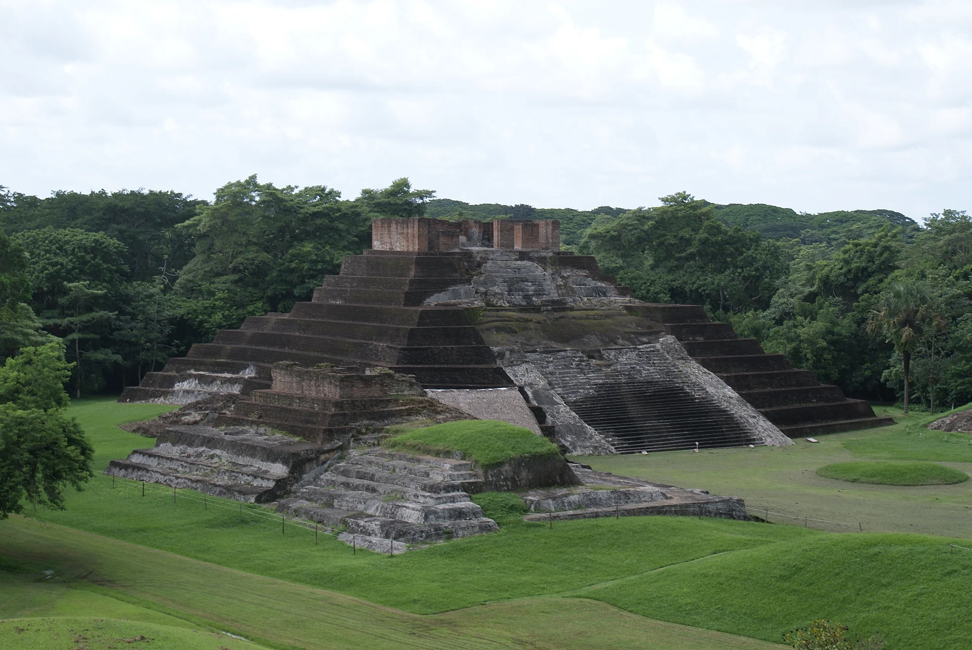
The westernmost Maya city, built of fired clay bricks set in oyster-shell mortar, with a grand acropolis and a museum of bricks carved with figures.
From Cárdenas: 50 min by car (44 km by road) How to get there ↓
Near here
See everything nearby ↓


Plan your visit to Comalcalco
Where to stay near Comalcalco
Compare hotels, posadas and guest houses in Comalcalco.
Tours to Comalcalco
A guide brings Comalcalco to life: look for tours from Frontera that include the site and the ride there.
 Tours from Villahermosa
Palenque Archaeological site from Villahermosa City or airport
★ 5.0 (9) · From US$184
How to get to Comalcalco
- From Cárdenas: about 50 min by road (~44 km)
- Nearest airport: Villahermosa (VSA), 1 h 6 min by car to Frontera
Links open a partner site. We may earn a commission if you book, at no cost to you.
Tours from Villahermosa, near Comalcalco


Tours, prices and ratings from Viator, checked weekly. We may earn a commission if you book.
About Comalcalco
The ruins of Comalcalco lie on the northern edge of the modern city of the same name, in the cacao country of the Chontalpa. It is the westernmost known city of the Classic Maya, and it flourished roughly between 300 and 900 AD, at the same time as and in close contact with Palenque. Inscriptions give its ancient name as Joy Chan, often translated as "surrounded sky"; the Nahuatl name Comalcalco, "house of the comals", came later. When the Spanish arrived the city had long been abandoned and the area was home to Chontal Maya communities.
What makes Comalcalco unusual is its building material. The alluvial plain of western Tabasco has almost no limestone, so its builders fired clay into flat bricks and laid them with a mortar of lime made by burning oyster shells, then covered the buildings in stucco. Many of the bricks were incised or modeled before firing with figures of people, animals, temples and glyphs, and some carry what look like makers' marks. Comalcalco's potters were also known for fine figurines and vessels traded far along the rivers and the Gulf coast, and the city sat in a region that produced cacao, a luxury drink and a form of money for the Maya.
The visit follows two main groups. The North Plaza is closed on the east by Temple I, a stepped brick pyramid that is the site's best-known image. To the south rises the Gran Acrópolis, a large artificial platform with palace buildings, tombs and temples, from which there are wide views over the plain and the cacao groves. The site museum at the entrance shows carved bricks, stucco heads and figurines found during excavations. Many signs are faded or in Spanish only, so a site guide can help, and the afternoon sun is strong.
How to get to Comalcalco
Drive from Cárdenas: 50 min, 44 km
The site is a few kilometers north of central Comalcalco, reached by a short side road off the Comalcalco–Paraíso highway (Federal 187). From Villahermosa, about 60 km away, take Federal 180 toward Cárdenas, turn north at the junction toward Cunduacán and continue to Comalcalco, roughly an hour's drive. Buses run between Villahermosa and Comalcalco every 20 minutes or so; from the town a taxi to the site takes a few minutes.
Directions to Comalcalco on Google Maps
Distances are in a straight line; the road is usually longer.
Links open a partner site. We may earn a commission if you book, at no cost to you.
From the nearest cities to Comalcalco
- Cárdenas · 44 km by road, 50 min
- Villahermosa · 54 km by road, 1 h
- Coatzacoalcos · 161 km by road, 2 h 10 min
Drive times by road from OpenStreetMap, without traffic or stops. Times marked ~ are estimated from the straight-line distance.
Before you go to Comalcalco: hours, prices and tips
- Hours
- Daily 9 am–5 pm, last entry 4 pm. INAH · checked Oct 2026
- Entry
- 155 pesos for foreign visitors and 85 pesos for Mexicans (INAH category II); the site museum is included. Discounts for students, teachers and seniors with ID. INAH · checked Oct 2026
- Guide or tour
- Site guardians can be hired as guides; English-speaking guides are not always available. Tours: Viator GetYourGuide Wikivoyage · checked Oct 2026
- What to bring
- Mosquito repellent, sunscreen and a hat; there is little shade in the afternoon. Wikivoyage · checked Oct 2026
- Rules
- No smoking, no food and no flash; professional cameras pay a fee. INAH · checked Oct 2026
Hours and prices change, especially around holidays. Each fact links to where we checked it.
Visiting Comalcalco: what to see and do
Look up at Temple I, the stepped brick pyramid on the North Plaza.
Climb the Gran Acrópolis for views over the plain and its cacao groves.
Look closely at the walls to see the thin fired bricks and oyster-shell mortar.
See the bricks carved with animals, people and glyphs in the site museum.
Combine the visit with a cacao hacienda tour in Comalcalco the same day.
Plan your trip
Places to stay in Comalcalco
Compare hotels, posadas, and rentals in and around Comalcalco.
Tours & activities
A guide brings Comalcalco to life: look for tours from Frontera that include the site and the ride there.
Rental cars
Pick up a car at VSA (Villahermosa): about 1 h 6 min by road to Frontera, then 64 km more to Comalcalco, on your own schedule.
Flights
The nearest airport with scheduled flights is Villahermosa (VSA), about 1 h 6 min by road from Frontera, the base for Comalcalco.
Mobile data
Signal can drop away from Frontera: download a map of the way to Comalcalco before you set out, or carry an eSIM with data.
Links open a partner site. We may earn a commission if you book, at no cost to you.
When to go to Comalcalco warm
Comalcalco shares the climate of Frontera, 64 km away. The best months to visit are January, February, November, and December.
See the month-by-month climate of Frontera
Weather in Comalcalco now and the next 7 days
Live forecast from Open-Meteo. Chance of rain is the day's highest.
The closest Pueblo Mágico: Frontera

Frontera is the Pueblo Mágico closest to Comalcalco, with places to stay, food, and more to see.
Closest to Comalcalco
-
Comalcalco · Town · 3 km away
-
Parque-Museo La Venta · Landmark · 42 km away
-
Villahermosa · City · 44 km away
-
Zona Luz · Landmark · 44 km away
Near Comalcalco




Drive times by road from OpenStreetMap, without traffic. Times marked ~ are estimated from the straight-line distance.
Location from OpenStreetMap. Written by Puebloteca.