Town Panotla, Tlaxcala Municipality of Panotla
Village in Panotla north of Tlaxcala city, with its San Judas Tadeo church, four barrios and its own carnival dance groups.
From Chiautempan: 20 min by car (20 km by road) How to get there ↓
Near here
See everything nearby ↓


Plan your visit to San Tadeo Huiloapan
Where to stay near San Tadeo Huiloapan
Compare hotels, posadas and guest houses in San Tadeo Huiloapan.
Tours to San Tadeo Huiloapan
Day trips around Huejotzingo sometimes stop in San Tadeo Huiloapan; a tour is the easy way to see it without a car.
 Tours from Puebla City
Africam Safari Zoo Admission with Transportation
★ 4.8 (87) · From US$35
How to get to San Tadeo Huiloapan
- From Chiautempan: about 20 min by road (~20 km)
- Nearest airport: Puebla (PBC), 7 min by car to Huejotzingo
Links open a partner site. We may earn a commission if you book, at no cost to you.
Tours from Puebla City, near San Tadeo Huiloapan


Tours, prices and ratings from Viator, checked weekly. We may earn a commission if you book.
About San Tadeo Huiloapan
San Tadeo Huiloapan is a village in the municipality of Panotla, at about 2,544 metres above sea level and 7.6 km north of the municipal seat. Its name comes from Nahuatl: huilotl, dove, and apan, river, roughly "river of the doves". The patron saint is Jude Thaddeus, which gives the "San Tadeo" in the name. INEGI counted 3,647 inhabitants in the 2020 census, making it the third-largest locality in the municipality after Panotla and San Jorge Tezoquipan; in 1990 there were 2,048, according to the Enciclopedia de los Municipios.
The Enciclopedia de los Municipios places it among the settlements of the area's old confederation of lordships, together with San Mateo Huexoyucan, in a society headed by military leaders and priests, followed by craftsmen in pottery, weaving and stonework. In the 19th century, in 1882, it appears among the localities that made up the municipality of Panotla when it was re-established. By the end of the 20th century its main activities were farming, livestock, forestry and fishing. The climate is temperate highland, with an average annual temperature of 13.4 °C and about 720 mm of rain a year.
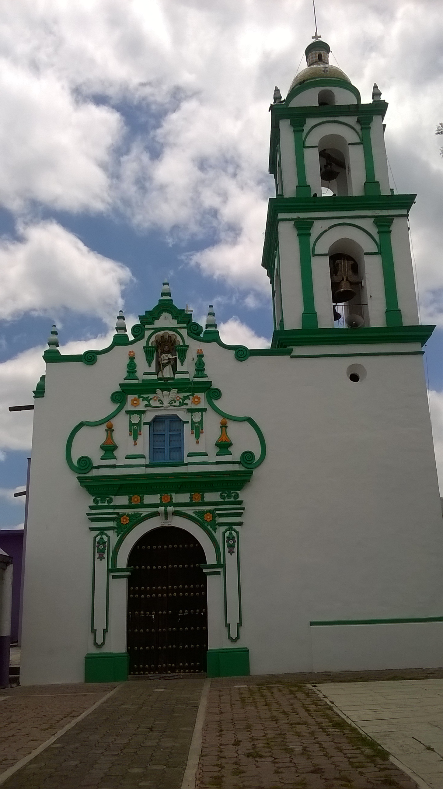
The church of San Judas Tadeo is the most visible building: a white facade with green mouldings and orange details, a niche holding an image of the saint above the choir window, and a two-storey bell tower topped by a tiled dome. At carnival the village dances with four camadas, one for each of its four barrios, which set off on the Sunday after Ash Wednesday from the house of the civil authorities and finish on Tuesday with a remate in the main square, from 1 pm to 8 pm.
How to get to San Tadeo Huiloapan
Drive from Chiautempan: 20 min, 20 km
San Tadeo Huiloapan lies about 11 km north of Tlaxcala city (about 15 minutes by car, per the OpenStreetMap routing estimate). Leave Tlaxcala on highway 117 toward San Martín Texmelucan, which passes through Panotla, then continue north about 7.6 km on local streets and roads to the village, at 2,544 m above sea level. From Puebla it is about 48 km (about 50 minutes) via the Tlaxcala ring road and the Puebla–Tlaxcala toll road. By public transport, start at the Tlaxcala bus terminal or the CAPU in Puebla, take local transport to Panotla and continue by colectivo or taxi to Huiloapan; there are no published lines or schedules. Huejotzingo, the nearest Pueblo Mágico in Puebla, is about 45 km by road (about 40 minutes).
Directions to San Tadeo Huiloapan on Google Maps
Distances are in a straight line; the road is usually longer.
Links open a partner site. We may earn a commission if you book, at no cost to you.
From the nearest cities to San Tadeo Huiloapan
- Chiautempan · 20 km by road, 20 min
- San Martín Texmelucan · 31 km by road, 25 min
- Huamantla · 54 km by road, 45 min
Drive times by road from OpenStreetMap, without traffic or stops. Times marked ~ are estimated from the straight-line distance.
Before you go to San Tadeo Huiloapan: hours, prices and tips
- Best season
- Carnival: starts on the Sunday after Ash Wednesday with four camadas, one per barrio; on Shrove Tuesday they gather in the main square for the remate, 1 pm to 8 pm. The patron saint is Jude Thaddeus; no local fiesta date is published. INAFED, Enciclopedia de los Municipios (Panotla) · checked Oct 2026
Hours and prices change, especially around holidays. Each fact links to where we checked it.
Visiting San Tadeo Huiloapan: what to see and do
The church of San Judas Tadeo, with its white and green facade and tiled-dome tower.
The belfry and its bells, overlooking the highland landscape.
The carnival of the four camadas, one per barrio, with the Tuesday remate in the main square.
The houses of the civil authorities, where each camada begins its dance every year.
The farmland and highland scenery north of Panotla.
Plan your trip
Places to stay in San Tadeo Huiloapan
Compare hotels, posadas, and rentals in and around San Tadeo Huiloapan.
Tours & activities
Day trips around Huejotzingo sometimes stop in San Tadeo Huiloapan; a tour is the easy way to see it without a car.
Rental cars
Pick up a car at PBC (Puebla): about 7 min by road to Huejotzingo, then 29 km more to San Tadeo Huiloapan, on your own schedule.
Flights
The nearest airport with scheduled flights is Puebla (PBC), about 7 min by road from Huejotzingo, the base for San Tadeo Huiloapan.
Mobile data
Signal can drop away from Huejotzingo: download a map of the way to San Tadeo Huiloapan before you set out, or carry an eSIM with data.
Links open a partner site. We may earn a commission if you book, at no cost to you.
When to go to San Tadeo Huiloapan mild
San Tadeo Huiloapan shares the climate of Huejotzingo, 29 km away. The best months to visit are January, February, March, and November.
See the month-by-month climate of Huejotzingo
Weather in San Tadeo Huiloapan now and the next 7 days
Live forecast from Open-Meteo. Chance of rain is the day's highest.
The closest Pueblo Mágico: Huejotzingo

Huejotzingo is the Pueblo Mágico closest to San Tadeo Huiloapan, with places to stay, food, and more to see.
Also close to
Closest to San Tadeo Huiloapan
-
San Mateo Huexoyucan · Village · 2 km away
-
San Francisco Temetzontla · Village · 4 km away
-
San Simón Tlatlahuquitepec · Village · 5 km away
-
Tepeticpac · Archaeological site · 5 km away
-
La Trinidad Chimalpa · Village · 6 km away
-
Los Reyes Quiahuixtlán · Town · 6 km away
-
San Damián Tlacocalpan · Village · 6 km away
-
San Juan Totolac · Town · 6 km away


Near San Tadeo Huiloapan


Drive times by road from OpenStreetMap, without traffic. Times marked ~ are estimated from the straight-line distance.
Location from OpenStreetMap. Written by Puebloteca.