
Village Panotla, Tlaxcala Municipality of Panotla
Locality of Panotla, once a regional centre of power, with a communal archive in a three-key chest holding papers from the 16th century.
From Chiautempan: 30 min by car (23 km by road) How to get there ↓
Near here
See everything nearby ↓


Plan your visit to San Mateo Huexoyucan
Where to stay near San Mateo Huexoyucan
Compare hotels, posadas and guest houses in San Mateo Huexoyucan.
Tours to San Mateo Huexoyucan
Day trips and guided outings from Huejotzingo often include San Mateo Huexoyucan; with a local guide you can get there without a car.
 Tours from Puebla City
Africam Safari Zoo Admission with Transportation
★ 4.8 (87) · From US$35
How to get to San Mateo Huexoyucan
- From Chiautempan: about 30 min by road (~23 km)
- Nearest airport: Puebla (PBC), 7 min by car to Huejotzingo
Links open a partner site. We may earn a commission if you book, at no cost to you.
Tours from Puebla City, near San Mateo Huexoyucan


Tours, prices and ratings from Viator, checked weekly. We may earn a commission if you book.
About San Mateo Huexoyucan
San Mateo Huexoyucan is a locality in the municipality of Panotla, at 2,527 metres above sea level and a few kilometres north of Tlaxcala city. Huexoyucan is Nahuatl and translates as "place where there are willows". The 2020 census counted 1,690 residents; its peak was 2,205 in 1990 and in 1900 it had 694. Historical writing places it, together with Santa Anita Nopalucan and Xaxantila, in the so-called Tlaxcala block and regards it as probably a regional centre of political, economic and religious power.
The village's most distinctive feature is its archive. An INAH article describes a three-key chest holding 185 folders of documents from the 16th to the 20th century: wills, deeds, censuses, maps and paintings. A paper of 1775 records that the chest was made on 21 August of that year and cost 27 pesos and 4 reales. Among the items are a parchment shield attributed to don Diego Tzoncozteuhtli and dated 1540, of Techialoyan type, and a 1568 painting of a land dispute between Baltasar Memeloc and Julián de Contreras. In an old drawing the church appears as "San Matheo Alhuexoyucan". The Comisión Vecinal looks after the chest.
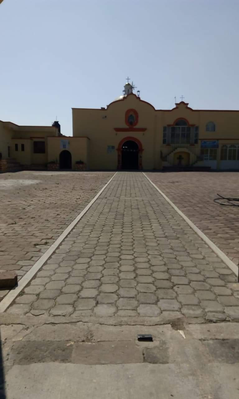
The church of San Mateo Apóstol, yellow with red trim and a wide paved atrium, dates from the 19th and 20th centuries according to the municipal catalogue. In November 2025 the community held a Feria del Tamal y el Atole. Panotla is known for pottery, with casseroles, jars and small mugs.
How to get to San Mateo Huexoyucan
Drive from Chiautempan: 30 min, 23 km
San Mateo Huexoyucan is about 4 km from Panotla (about 8 minutes) and about 14 km from Tlaxcala city (about 21 minutes). From Tlaxcala take highway 117 (Tlaxcala–San Martín Texmelucan), then Avenida Juárez and Calle Independencia to the village. From Puebla it is about 51 km (about 53 minutes) via the Puebla–Tlaxcala motorway (119D), the 117D and the Mexico–Puebla motorway (150D). Huejotzingo, a Pueblo Mágico in Puebla, is about 43 km away (about 43 minutes) via the 117D, the Arco Norte and the vía corta a San Martín. There are no published bus lines or colectivo timetables for the village; the practical way in is by car or taxi from Panotla or Tlaxcala. Distances and times are computed on the OpenStreetMap road network, without traffic.
Directions to San Mateo Huexoyucan on Google Maps
Distances are in a straight line; the road is usually longer.
Links open a partner site. We may earn a commission if you book, at no cost to you.
From the nearest cities to San Mateo Huexoyucan
- Chiautempan · 23 km by road, 30 min
- San Martín Texmelucan · 28 km by road, 30 min
- Puebla · 48 km by road, 55 min
Drive times by road from OpenStreetMap, without traffic or stops. Times marked ~ are estimated from the straight-line distance.
Visiting San Mateo Huexoyucan: what to see and do
The church of San Mateo Apóstol, yellow with red trim, and its paved atrium
The communal archive: a three-key chest made in 1775, with 185 folders of papers from the 16th to the 20th century
The church of San Nicolás de Bari in Panotla (1693), one of the finest examples of popular Baroque
The sanctuary of Nuestra Señora de la Defensa, 17th and 18th centuries, in the municipality
The Feria del Tamal y el Atole, held in November 2025
Plan your trip
Places to stay in San Mateo Huexoyucan
Compare hotels, posadas, and rentals in and around San Mateo Huexoyucan.
Tours & activities
Day trips and guided outings from Huejotzingo often include San Mateo Huexoyucan; with a local guide you can get there without a car.
Rental cars
Pick up a car at PBC (Puebla): about 7 min by road to Huejotzingo, then 27 km more to San Mateo Huexoyucan, on your own schedule.
Flights
The nearest airport with scheduled flights is Puebla (PBC), about 7 min by road from Huejotzingo, the base for San Mateo Huexoyucan.
Mobile data
Signal can drop away from Huejotzingo: download a map of the way to San Mateo Huexoyucan before you set out, or carry an eSIM with data.
Links open a partner site. We may earn a commission if you book, at no cost to you.
When to go to San Mateo Huexoyucan mild
San Mateo Huexoyucan shares the climate of Huejotzingo, 27 km away. The best months to visit are January, February, March, and November.
See the month-by-month climate of Huejotzingo
Weather in San Mateo Huexoyucan now and the next 7 days
Live forecast from Open-Meteo. Chance of rain is the day's highest.
The closest Pueblo Mágico: Huejotzingo

Huejotzingo is the Pueblo Mágico closest to San Mateo Huexoyucan, with places to stay, food, and more to see.
Also close to
Closest to San Mateo Huexoyucan
-
San Tadeo Huiloapan · Town · 2 km away
-
San Francisco Temetzontla · Village · 3 km away
-
La Trinidad Tenexyecac · Village · 6 km away
-
Los Reyes Quiahuixtlán · Town · 6 km away
-
San Juan Totolac · Town · 6 km away
-
Santa Cruz Techachalco · Village · 6 km away
-
Tepeticpac · Archaeological site · 6 km away
-
La Trinidad Chimalpa · Village · 7 km away


Near San Mateo Huexoyucan


Drive times by road from OpenStreetMap, without traffic. Times marked ~ are estimated from the straight-line distance.
Location from OpenStreetMap. Written by Puebloteca.