Nature reserve Tlaxcala Municipality of Tlaxcala
A 1937 national park covering Tlaxcala's historic centre, the Zahuapan River and the hills of three of the old Tlaxcalan lordships.
From Chiautempan: 10 min by car (6 km by road) How to get there ↓
Near here
See everything nearby ↓


Plan your visit to Parque nacional Xicoténcatl
Where to stay near Parque nacional Xicoténcatl
Compare hotels, posadas and guest houses in Parque nacional Xicoténcatl.
Tours to Parque nacional Xicoténcatl
Day trips and guided outings from Huejotzingo often include Parque nacional Xicoténcatl; with a local guide you can get there without a car.
 Tours from Puebla City
Africam Safari Zoo Admission with Transportation
★ 4.8 (87) · From US$35
How to get to Parque nacional Xicoténcatl
- From Chiautempan: about 10 min by road (~6 km)
- Nearest airport: Puebla (PBC), 7 min by car to Huejotzingo
Links open a partner site. We may earn a commission if you book, at no cost to you.
Tours from Puebla City, near Parque nacional Xicoténcatl


Tours, prices and ratings from Viator, checked weekly. We may earn a commission if you book.
About Parque nacional Xicoténcatl
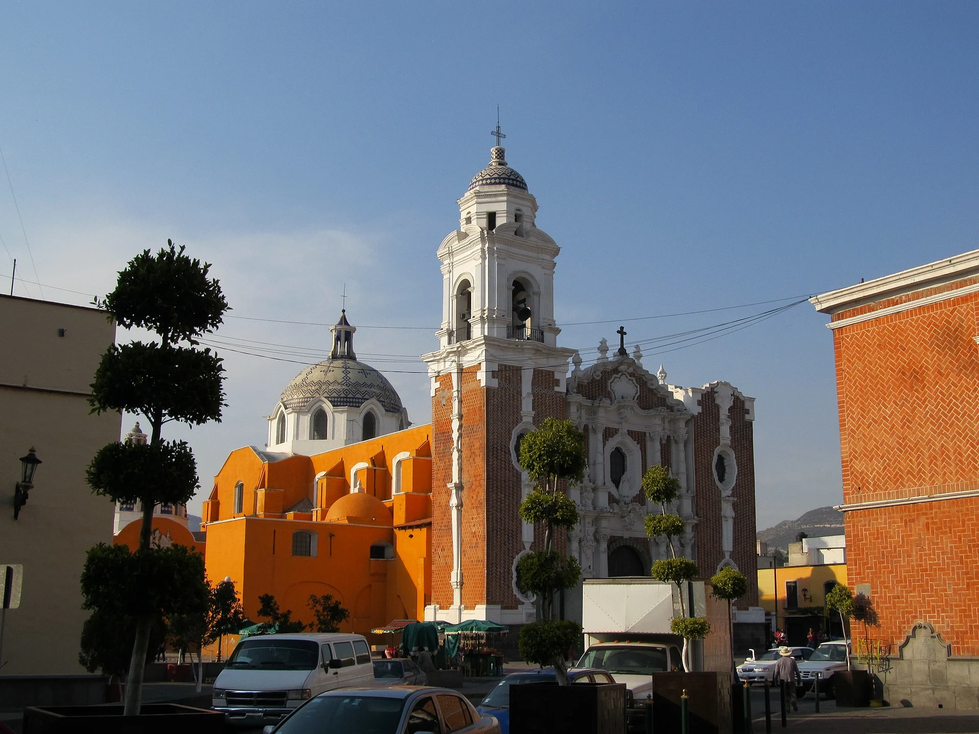
Xicoténcatl National Park is one of Mexico's more unusual protected areas: instead of a forest or a mountain, it protects a city and its surroundings. Lázaro Cárdenas signed the decree on 4 November 1937, at the urging of engineer Miguel Ángel de Quevedo, head of the Forestry Department, and it was published in the Diario Oficial on 17 November. It created a national park called "Xicoténcatl, Historic Monuments of Tlaxcala", meant to conserve the city's convents and churches and to replant the hills around them.
The decree names the Franciscan convent of San Francisco, which it calls the oldest in New Spain, the sanctuary of Ocotlán and the village of San Esteban Tizatlán. Its boundary starts at Tizatlán, runs down to a spot called the Palace of Zitlalpopoca and comes back past the place where the brigantines for the siege of Tenochtitlan were built. Today the park takes in Tlaxcala's historic centre and villages in the municipalities of Tlaxcala and Totolac such as Los Reyes Quiahuixtlán, San Francisco Ocotelulco and Santiago Tepeticpac, three of the four old lordships of Tlaxcallan. Wikipedia gives it about 600 hectares and SEMARNAT's tables 851. The land remains in the hands of its owners.
The landscape is a valley between two lines of hills, the highest being Oztol at about 2,460 metres and Tepepan at 2,320. Through the middle runs the Zahuapan River, which flows about 7 km through the capital and forms the border between Tlaxcala and Totolac. The slopes carry pine, oak and white cedar, with scrub of juniper, palo dulce, nopal and tepozán, and the riverbanks have ahuehuete cypresses, willows and ash trees. CONABIO records more than 380 species of plants and animals, seven of them listed as at risk; even inside the city there are rabbits, squirrels and opossums, and Mexican jays and curve-billed thrashers are easy to spot. The climate is mild, with summer rains.
How to get to Parque nacional Xicoténcatl
Drive from Chiautempan: 10 min, 6 km
The park begins in the centre of Tlaxcala itself, so getting there means getting to the city. Buses reach Tlaxcala's bus station from Mexico City's TAPO terminal (about 1 hr 50 min; ATAH and Suprabus hourly) and from Puebla (about 50 minutes; Verdes is the main line). By car it is about two hours from Mexico City and one hour from Puebla. Inside the park, the historic centre is best walked; Ocotelulco and Tepeticpac, on the Totolac hills, are about 10 minutes away by car or taxi, and combis also run to Totolac for Tepeticpac. Puebla is about 31 km away and Huejotzingo, the nearest Pueblo Mágico, about 25 km in a straight line.
Directions to Parque nacional Xicoténcatl on Google Maps
Distances are in a straight line; the road is usually longer.
Links open a partner site. We may earn a commission if you book, at no cost to you.
From the nearest cities to Parque nacional Xicoténcatl
- Chiautempan · 6 km by road, 10 min
- San Martín Texmelucan · 24 km by road, 20 min
- Huamantla · 46 km by road, 35 min
Drive times by road from OpenStreetMap, without traffic or stops. Times marked ~ are estimated from the straight-line distance.
Before you go to Parque nacional Xicoténcatl: hours, prices and tips
- Best time of day
- Mild all year; the rains come in summer. Wikipedia · checked Oct 2026
Hours and prices change, especially around holidays. Each fact links to where we checked it.
Visiting Parque nacional Xicoténcatl: what to see and do
The former convent of San Francisco, named in the 1937 decree.
The sanctuary of Ocotlán, the other church named in the decree.
The Ocotelulco archaeological site and its museum.
The hilltop fortress of Tepeticpac in the Totolac hills.
The banks of the Zahuapan River, lined with ahuehuete cypresses, willows and ash trees.
Plan your trip
Places to stay in Parque nacional Xicoténcatl
Compare hotels, posadas, and rentals in and around Parque nacional Xicoténcatl.
Tours & activities
Day trips and guided outings from Huejotzingo often include Parque nacional Xicoténcatl; with a local guide you can get there without a car.
Rental cars
Pick up a car at PBC (Puebla): about 7 min by road to Huejotzingo, then 25 km more to Parque nacional Xicoténcatl, on your own schedule.
Flights
The nearest airport with scheduled flights is Puebla (PBC), about 7 min by road from Huejotzingo, the base for Parque nacional Xicoténcatl.
Travel insurance
If you plan on hiking at Parque nacional Xicoténcatl, check that your policy covers it: some plans leave adventure activities out.
Mobile data
Signal can drop away from Huejotzingo: download a map of the way to Parque nacional Xicoténcatl before you set out, or carry an eSIM with data.
Links open a partner site. We may earn a commission if you book, at no cost to you.
When to go to Parque nacional Xicoténcatl mild
Parque nacional Xicoténcatl shares the climate of Huejotzingo, 25 km away. The best months to visit are January, February, March, and November.
See the month-by-month climate of Huejotzingo
Weather in Parque nacional Xicoténcatl now and the next 7 days
Live forecast from Open-Meteo. Chance of rain is the day's highest.
The closest Pueblo Mágico: Huejotzingo

Huejotzingo is the Pueblo Mágico closest to Parque nacional Xicoténcatl, with places to stay, food, and more to see.
Also close to
Closest to Parque nacional Xicoténcatl
-
Catedral de Nuestra Señora de la Asunción · Landmark · 0 km away
-
Escalinatas de los Héroes · Viewpoint · 0 km away
-
Museo Regional de Tlaxcala · Landmark · 0 km away
-
Palacio de Gobierno de Tlaxcala · Landmark · 0 km away
-
Tlaxcala · City · 0 km away
-
iglesia de San José · Landmark · 0 km away
-
Acxotla del Río · Town · 1 km away
-
Basílica de Ocotlán · Landmark · 1 km away


Near Parque nacional Xicoténcatl


Drive times by road from OpenStreetMap, without traffic. Times marked ~ are estimated from the straight-line distance.
Lists with Parque nacional Xicoténcatl
Nature Parks near San Martín Texmelucan · 6 Nature Parks near Puebla · 4 Nature Parks near Atlixco · 5Location from OpenStreetMap. Written by Puebloteca.