
Town Tlaxcala Municipality of Tlaxcala
The hill town above central Tlaxcala, the municipality's most populous locality, with the Pocito holy-water chapel and the basilica on top.
From Chiautempan: 10 min by car (5 km by road) How to get there ↓
Near here


Plan your visit to Ocotlán
Where to stay near Ocotlán
Compare hotels, posadas and guest houses in Ocotlán.
Tours to Ocotlán
Day trips around Huejotzingo sometimes stop in Ocotlán; a tour is the easy way to see it without a car.
 Private Tour: A Day of Faith in Tlaxcala whit Puebla
★ 5.0 (1) · From US$186
How to get to Ocotlán
- From Chiautempan: about 10 min by road (~5 km)
- Nearest airport: Puebla (PBC), 7 min by car to Huejotzingo
Links open a partner site. We may earn a commission if you book, at no cost to you.
Popular tours to Ocotlán
Tours, prices and ratings from Viator, checked weekly. We may earn a commission if you book.
About Ocotlán
Ocotlán is the community on the hill just east of central Tlaxcala, now joined to the capital's built-up area but with its own community council. Many people know it only for its basilica, yet it is the most populous locality in the municipality: 24,342 people at the 2020 census, almost twice the 13,555 of the municipal seat, Tlaxcala de Xicohténcatl. The name comes from the Nahuatl ocotl, the ocote pine, and is usually translated as "place of pines" or "the burning pine", after the pine wood that once covered the hill.
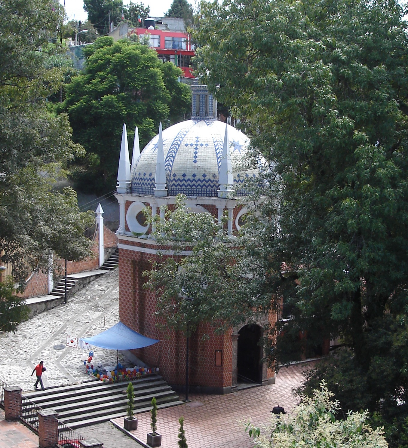
The town's story is about water. Tradition holds that in 1541, during an epidemic, a woman appeared to an Indigenous man named Juan Diego Bernardino beside a spring at the foot of the hill and told him its water would heal the sick. Before the present shrine, the hilltop held only a small chapel to St Lawrence. The spring is still sheltered by the Capilla del Pocito, half a kilometre from the basilica: a first chapel stood here in the 18th century, and the present octagonal one, clad in red petatillo brick under a tiled dome, went up in 1973. Inside, murals of biblical scenes involving water by the Tlaxcalan painters Desiderio Hernández Xochitiotzin and Pedro Avelino share the walls with a canvas by Ysauro G. Cervantes dated 1913.
From the Pocito the cobbled Calle del Agua Santa climbs to the shrine, the route pilgrims walk. In June 2026 INAH and the state government lit the chapel and the street with 165 LED fittings; both lie in zone B of the city's historic monuments district. At the top stands the Basilica of Our Lady of Ocotlán, which has its own page in this guide. The image leaves its niche on 1 January and in May, when the bajada and subida processions carry it between the hill and the city centre and the whole neighbourhood fills with visitors.
How to get to Ocotlán
Drive from Chiautempan: 10 min, 5 km
Ocotlán begins a few blocks from Tlaxcala's main square; you can walk up or take a taxi. From the square walk two blocks north on Avenida Independencia, turn right on Guridi y Alcocer and take the left-hand fork uphill to the basilica; the Capilla del Pocito is half a kilometre away at the foot of Calle del Agua Santa. To reach Tlaxcala, Suprabus and ATAH run hourly buses from Mexico City's TAPO terminal (about 1 h 50 min) and Verdes buses come from Puebla's CAPU (about 50 min) to Tlaxcala's bus terminal on the Tepehitec road. Huejotzingo, the nearest Pueblo Mágico, is about 26 km away (roughly 30 min by car).
Directions to Ocotlán on Google Maps
Distances are in a straight line; the road is usually longer.
Links open a partner site. We may earn a commission if you book, at no cost to you.
From the nearest cities to Ocotlán
- Chiautempan · 5 km by road, 10 min
- San Martín Texmelucan · 25 km by road, 20 min
- Puebla · 35 km by road, 40 min
Drive times by road from OpenStreetMap, without traffic or stops. Times marked ~ are estimated from the straight-line distance.
What to see in Ocotlán 10
Sights with their own page, closest to the centre first.
Landmarks and museums
-
Basílica de Ocotlán · Landmark · in the centre
Tlaxcala's hilltop pilgrimage church: a churrigueresque façade between 33 m towers and an octagonal camarín carved by an indigenous artist. -
Catedral de Nuestra Señora de la Asunción · Landmark · 1 km from the centre
The 16th-century Franciscan church of the Asunción, with a Mudéjar cedar ceiling; Tlaxcala's cathedral and a World Heritage Site since 2021. -
Museo Regional de Tlaxcala · Landmark · 1 km from the centre
INAH museum in the cloister of Tlaxcala's Franciscan convent of the Assumption: 13 rooms running from the Paleolithic to the 20th century. -
Palacio de Gobierno de Tlaxcala · Landmark · 1 km from the centre
Seat of Tlaxcala's government since colonial times, on the Plaza de la Constitución; its arcades hold Desiderio Hernández Xochitiotzin's history murals. -
iglesia de San José · Landmark · 1 km from the centre
17th-century baroque church in central Tlaxcala, twice a cathedral and restored after the 2017 quake; home of the Niño Milagroso image.

Archaeological sites
-
Ocotelulco · Archaeological site · 2 km from the centre
Temple and painted altar of Maxixcatzin's lordship, with a site museum, in San Francisco Ocotelulco, 3 km from Tlaxcala city. Free entry. -
Zona Arqueológica de Tizatlán · Archaeological site · 3 km from the centre
Seat of a Tlaxcalan lordship where the alliance with Cortés was sealed, with painted altars beside a 16th-century open chapel. -
Tepeticpac · Archaeological site · 4 km from the centre
Pre-Hispanic hilltop fortress above Santiago Tepeticpac, 5 km north of Tlaxcala city: walls, terraces, watchtowers and views over the valley.


Nature reserves
-
Parque nacional Xicoténcatl · Nature reserve · 1 km from the centre
A 1937 national park covering Tlaxcala's historic centre, the Zahuapan River and the hills of three of the old Tlaxcalan lordships.
Viewpoints
-
Escalinatas de los Héroes · Viewpoint · 2 km from the centre
A 1960s flight of 250 steps with a central fountain and statues of national heroes, climbing to a lookout over Tlaxcala city.

Map of Ocotlán
Neighbourhoods and villages of Ocotlán
Part of Ocotlán or just outside it, closest first.
-
Acxotla del Río · Town · 1 km from the centre
Totolac community beside the Zahuapan river, with an 1876 Nativity church and a Virgin procession eight days before 8 September. -
San Buenaventura Atempan · Village · 1 km from the centre
Village in Tlaxcala municipality tied to Cortés's brigantines; it has an old aqueduct and a fiesta of St Bonaventure on 15 July. -
San Gabriel Cuauhtla · Town · 1 km from the centre
Locality south of Tlaxcala city next to Ocotlán: once brick and tile makers, now housing estates, with a chapel of San Gabriel. -
San Miguel Tlamahuco · Village · 1 km from the centre
Village of 1,108 people next to Tlaxcala city, with a red-domed church on a small hill and La Malinche behind it. -
La Trinidad Chimalpa · Village · 2 km from the centre
Old community in Totolac right beside Tlaxcala city, with a church to the Holy Trinity and a patron-saint fiesta in June. -
San Esteban Tizatlán · Town · 2 km from the centre
Old seat of Xicohténcatl's lordship, northeast of Tlaxcala city: pre-Hispanic painted altars, a 16th-century open chapel and carved walking sticks. -
San Francisco Ocotelulco · Village · 2 km from the centre
Totolac village next to Tlaxcala, heir to the lordship of Ocotelulco, with the church of San Francisco de Asís and the ruins close by. -
San Hipólito Chimalpa · Town · 2 km from the centre
Village in Tlaxcala municipality about 2 km from the capital's centre, with a yellow-domed church to Saint Hippolytus and views of La Malinche. -
Santiago Tepeticpac · Village · 2 km from the centre
A Totolac village at 2,244 m below Tepeticpac hill; every 3 May it climbs in procession to the old church on the summit. -
La Trinidad Tepehitec · Town · 3 km from the centre
Tlaxcala's "Heroic Town" by the city bus terminal: a hub of the 1910 anti-reelection movement, with one of the state's liveliest Day of the Dead nights. -
Los Reyes Quiahuixtlán · Town · 3 km from the centre
Totolac hill town just north of Tlaxcala city, heir to the Quiahuixtlán lordship, with cave paintings at Los Molinos and a Three Kings fiesta. -
San Juan Totolac · Town · 3 km from the centre
Seat of Totolac, 3 km from Tlaxcala city: an 1714 parish church and the festival bread baked every week. -
San Sebastián Atlahapa · Town · 3 km from the centre
Locality of 6,503 people in Tlaxcala municipality beside the bypass, with a church with a painted dome dedicated to Saint Sebastian. -
Santa Cruz Tetela · Village · 3 km from the centre
A Chiautempan village at 2,295 m, with prickly-pear groves and farm plots; its Nahuatl name means stony place. -
Santa María Ixtulco · Town · 3 km from the centre
Birthplace of governor Próspero Cahuantzi, with a Candelaria festival on 2 February, a tamal and mole prieto fair and five carnival camadas. -
Tlatempan · Town · 3 km from the centre
Apetatitlán locality with the Padre Jesús church and workshops making wooden masks for dancers. -
Apetatitlán de Antonio Carvajal · Town · 4 km from the centre
San Pablo Apetatitlán, an old staging town on the Veracruz road 7 km from Tlaxcala, with a protected historic core and the Baroque San Pablo church. -
Chiautempan · Town · 4 km from the centre
Santa Ana Chiautempan, 6 km from Tlaxcala: the cradle of the sarape, with a July fair, a 16th-century Franciscan convent and mole prieto. -
Panotla · Town · 4 km from the centre
Municipal seat 4 km west of Tlaxcala, with the Baroque church of San Nicolás de Bari and a name in carnival and clarinet music. -
San Lucas Cuauhtelulpan · Town · 4 km from the centre
Locality in Tlaxcala municipality with 5,185 people in 2020, patron Saint Luke the Evangelist and a Nahuatl name meaning "on the wooded mound". -
Santa María Acuitlapilco · Town · 4 km from the centre
Large locality south of the state capital, beside the lagoon that bears its name and known for its huehues and the dance of El Palomo.


Day trips and tours from Ocotlán
The closest Pueblos Mágicos and places to visit, with the drive from Ocotlán and tours that leave from it.


Times marked ~ are estimated from the distance. Links open a partner site. We may earn a commission if you book, at no cost to you.
Before you go: getting to and around Ocotlán
- The nearest airport is Puebla (PBC).
- The best months to go are January, February, March, and November.
- 6 of the places on this page are more than 3 km from the centre: take a taxi, a ride-hailing app or a local bus.
- For day trips a rental car gives the most freedom; the tours above leave from Ocotlán.
Before you go to Ocotlán: hours, prices and tips
- Best season
- The Virgin's image comes out on 1 January and on two Mondays in May (the bajada and subida processions between the hill and the city). Wikipedia: Virgin of Ocotlán · checked Oct 2026
Hours and prices change, especially around holidays. Each fact links to where we checked it.
Visiting Ocotlán: what to see and do
The octagonal, tile-domed Capilla del Pocito over the spring of the 1541 tradition.
The water-themed murals by Desiderio Hernández Xochitiotzin and Pedro Avelino inside the Pocito.
The cobbled Calle del Agua Santa, lit at night since 2026.
The Basilica of Our Lady of Ocotlán at the top of the hill.
The May bajada and subida processions of the Virgin.
Plan your trip
Places to stay in Ocotlán
Compare hotels, posadas, and rentals in and around Ocotlán.
Tours & activities
Day trips around Huejotzingo sometimes stop in Ocotlán; a tour is the easy way to see it without a car.
Rental cars
Pick up a car at PBC (Puebla): about 7 min by road to Huejotzingo, then 26 km more to Ocotlán, on your own schedule.
Flights
The nearest airport with scheduled flights is Puebla (PBC), about 7 min by road from Huejotzingo, the base for Ocotlán.
Mobile data
Signal can drop away from Huejotzingo: download a map of the way to Ocotlán before you set out, or carry an eSIM with data.
Links open a partner site. We may earn a commission if you book, at no cost to you.
When to go to Ocotlán mild
Ocotlán shares the climate of Huejotzingo, 26 km away. The best months to visit are January, February, March, and November.
See the month-by-month climate of Huejotzingo
Weather in Ocotlán now and the next 7 days
Live forecast from Open-Meteo. Chance of rain is the day's highest.
The closest Pueblo Mágico: Huejotzingo

Huejotzingo is the Pueblo Mágico closest to Ocotlán, with places to stay, food, and more to see.
Also close to
Near Ocotlán


Drive times by road from OpenStreetMap, without traffic. Times marked ~ are estimated from the straight-line distance.
Location from OpenStreetMap. Written by Puebloteca.