
Village Ixtacuixtla de Mariano Matamoros, Tlaxcala Municipality of Ixtacuixtla de Mariano Matamoros
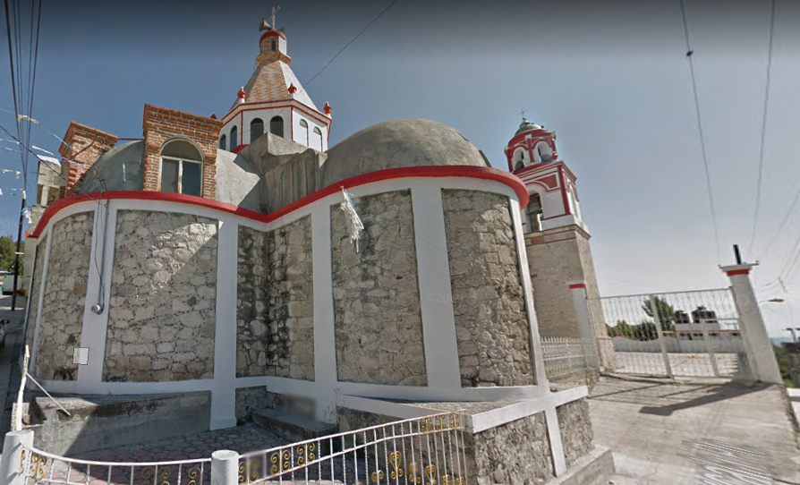
Village at 2,252 m in Ixtacuixtla, with a church of St Anthony of Padua near the Tlaxcala–San Martín Texmelucan highway.
From San Martín Texmelucan: 10 min by car (13 km by road) How to get there ↓
Near here
See everything nearby ↓


Plan your visit to San Antonio Tizostoc
Where to stay near San Antonio Tizostoc
Compare hotels, posadas and guest houses in San Antonio Tizostoc.
Tours to San Antonio Tizostoc
Day trips and guided outings from Huejotzingo often include San Antonio Tizostoc; with a local guide you can get there without a car.
 Tours from Puebla City
Africam Safari Zoo Admission with Transportation
★ 4.8 (87) · From US$35
How to get to San Antonio Tizostoc
- From San Martín Texmelucan: about 10 min by road (~13 km)
- Nearest airport: Puebla (PBC), 7 min by car to Huejotzingo
Links open a partner site. We may earn a commission if you book, at no cost to you.
Tours from Puebla City, near San Antonio Tizostoc


Tours, prices and ratings from Viator, checked weekly. We may earn a commission if you book.
About San Antonio Tizostoc
San Antonio Tizostoc is a locality in the municipality of Ixtacuixtla de Mariano Matamoros, in western Tlaxcala, at roughly 2,252 metres above sea level. INEGI counted 2,130 people there in the 2020 census; the population has grown steadily from 436 in 1900 and 1,341 in 1980. Its patron saint is St Anthony of Padua, who gives the village its name.
Tizostoc is a Nahuatl word. Wikipedia breaks it into tizatl (chalk), oztotl (cave) and the locative suffix -co, so something like "place of the chalk cave", though the article does not settle on a final translation. The village appears by name in the municipality's agrarian history: the Enciclopedia de los Municipios lists Tizostoc among the towns that filed land petitions in 1917, alongside Ixtacuixtla, Xocoyucan and Tezoquipan, when peasants claimed the ejidos of neighbouring haciendas. In the early 2000s the same source recorded commerce and services, rather than farming, as its main activity.
The building that anchors the village is the church of San Antonio, which the municipal catalogue places about 500 metres off the Tlaxcala–San Martín Texmelucan highway, at the junction heading north. It is a stone-walled building with a dome and a bell tower painted white and red. The whole municipality lies on the Cacaxtla and Xochitécatl tourist route, and in the surrounding area families make paper flowers, baskets, piñatas and alebrijes, crafts the encyclopedia credits to Ixtacuixtla's artisans in general.
How to get to San Antonio Tizostoc
Drive from San Martín Texmelucan: 10 min, 13 km
Tizostoc sits by the Tlaxcala–San Martín Texmelucan highway, the same road (federal 117, Tlaxcala–Popocatla–San Martín) that reaches Villa Mariano Matamoros, the municipal seat, about 15 km from Tlaxcala city according to the Enciclopedia de los Municipios. From Tlaxcala, take that highway west and, at the junction the municipal catalogue describes, follow a street north for about 500 m to the church of San Antonio. From Puebla it is about 35 km, around 40 minutes by car; the nearest pueblo on our list, Huejotzingo, is about 21 km away, roughly 25 minutes. There are no published public transport schedules for the village; without a car, go to Tlaxcala's bus terminal and look for local transport toward Ixtacuixtla and Villa Mariano Matamoros.
Directions to San Antonio Tizostoc on Google Maps
Distances are in a straight line; the road is usually longer.
Links open a partner site. We may earn a commission if you book, at no cost to you.
From the nearest cities to San Antonio Tizostoc
- San Martín Texmelucan · 13 km by road, 10 min
- Chiautempan · 21 km by road, 20 min
- Huamantla · 54 km by road, 40 min
Drive times by road from OpenStreetMap, without traffic or stops. Times marked ~ are estimated from the straight-line distance.
Visiting San Antonio Tizostoc: what to see and do
The church of San Antonio, stone-built with a white and red tower, 500 m from the highway.
The village square and streets, at 2,252 m above sea level.
Paper flowers, baskets, piñatas and alebrijes, the typical crafts of Ixtacuixtla.
Cacaxtla and Xochitécatl, the archaeological sites on the tourist route that includes the municipality.
Plan your trip
Places to stay in San Antonio Tizostoc
Compare hotels, posadas, and rentals in and around San Antonio Tizostoc.
Tours & activities
Day trips and guided outings from Huejotzingo often include San Antonio Tizostoc; with a local guide you can get there without a car.
Rental cars
Pick up a car at PBC (Puebla): about 7 min by road to Huejotzingo, then 21 km more to San Antonio Tizostoc, on your own schedule.
Flights
The nearest airport with scheduled flights is Puebla (PBC), about 7 min by road from Huejotzingo, the base for San Antonio Tizostoc.
Mobile data
Signal can drop away from Huejotzingo: download a map of the way to San Antonio Tizostoc before you set out, or carry an eSIM with data.
Links open a partner site. We may earn a commission if you book, at no cost to you.
When to go to San Antonio Tizostoc mild
San Antonio Tizostoc shares the climate of Huejotzingo, 21 km away. The best months to visit are January, February, March, and November.
See the month-by-month climate of Huejotzingo
Weather in San Antonio Tizostoc now and the next 7 days
Live forecast from Open-Meteo. Chance of rain is the day's highest.
The closest Pueblo Mágico: Huejotzingo

Huejotzingo is the Pueblo Mágico closest to San Antonio Tizostoc, with places to stay, food, and more to see.
Also close to
Closest to San Antonio Tizostoc
-
San Antonio Tecóac · Village · 1 km away
-
La Trinidad Tenexyecac · Village · 2 km away
-
San Jorge Tezoquipan · Town · 3 km away
-
Santa Cruz Techachalco · Village · 3 km away
-
Santa Justina Ecatepec · Town · 3 km away
-
Santa Ana Nopalucan · Town · 4 km away
-
Santa Inés Tecuexcomac · Town · 4 km away
-
San Francisco Temetzontla · Village · 5 km away


Near San Antonio Tizostoc


Drive times by road from OpenStreetMap, without traffic. Times marked ~ are estimated from the straight-line distance.
Location from OpenStreetMap. Written by Puebloteca.