Town Santa Ana Nopalucan, Tlaxcala Volcano Route Monasteries on the slopes of Popocatépetl Puebla Valley
Municipal seat in south-western Tlaxcala, a former producer of reed and salt, with the church of Santa Ana and a feast on 26 July.
From San Martín Texmelucan: 15 min by car (15 km by road) How to get there ↓
Near here


Plan your visit to Santa Ana Nopalucan
Where to stay near Santa Ana Nopalucan
Compare hotels, posadas and guest houses in Santa Ana Nopalucan.
Tours to Santa Ana Nopalucan
Day trips around Huejotzingo sometimes stop in Santa Ana Nopalucan; a tour is the easy way to see it without a car.
 Tours from Puebla City
Africam Safari Zoo Admission with Transportation
★ 4.8 (87) · From US$35
How to get to Santa Ana Nopalucan
- From San Martín Texmelucan: about 15 min by road (~15 km)
- Nearest airport: Puebla (PBC), 7 min by car to Huejotzingo
Links open a partner site. We may earn a commission if you book, at no cost to you.
Tours from Puebla City, near Santa Ana Nopalucan


Tours, prices and ratings from Viator, checked weekly. We may earn a commission if you book.
About Santa Ana Nopalucan
Santa Ana Nopalucan is the seat of the municipality of the same name, in south-western Tlaxcala, at about 2,200 metres above sea level. At the 2020 census the locality had 7,951 inhabitants, up from 782 in 1900 and 3,219 in 1980. The municipality covers barely 9 km² and is crossed by the Rojano river. It was once called Santa Anita because of its small population.
According to the accounts compiled on the place, the area was inhabited by Nahuas before the conquest and its first settlers are linked to the Olmeca-Xicalanca culture; Nopalucan was a passage toward Cacaxtla and Xochitécatl. During the Mexica siege of Tlaxcala, the tequesquite gathered here and at El Carmen Tequexquitla replaced sea salt. Reed taken from the ditches that separated the waters of the lagunillas was made into petates sold since pre-Hispanic times. In 1623 fray Blas de Escobar recorded 107 people at the visita; the church was secularised in 1640 and the convent only on 29 May 1770.
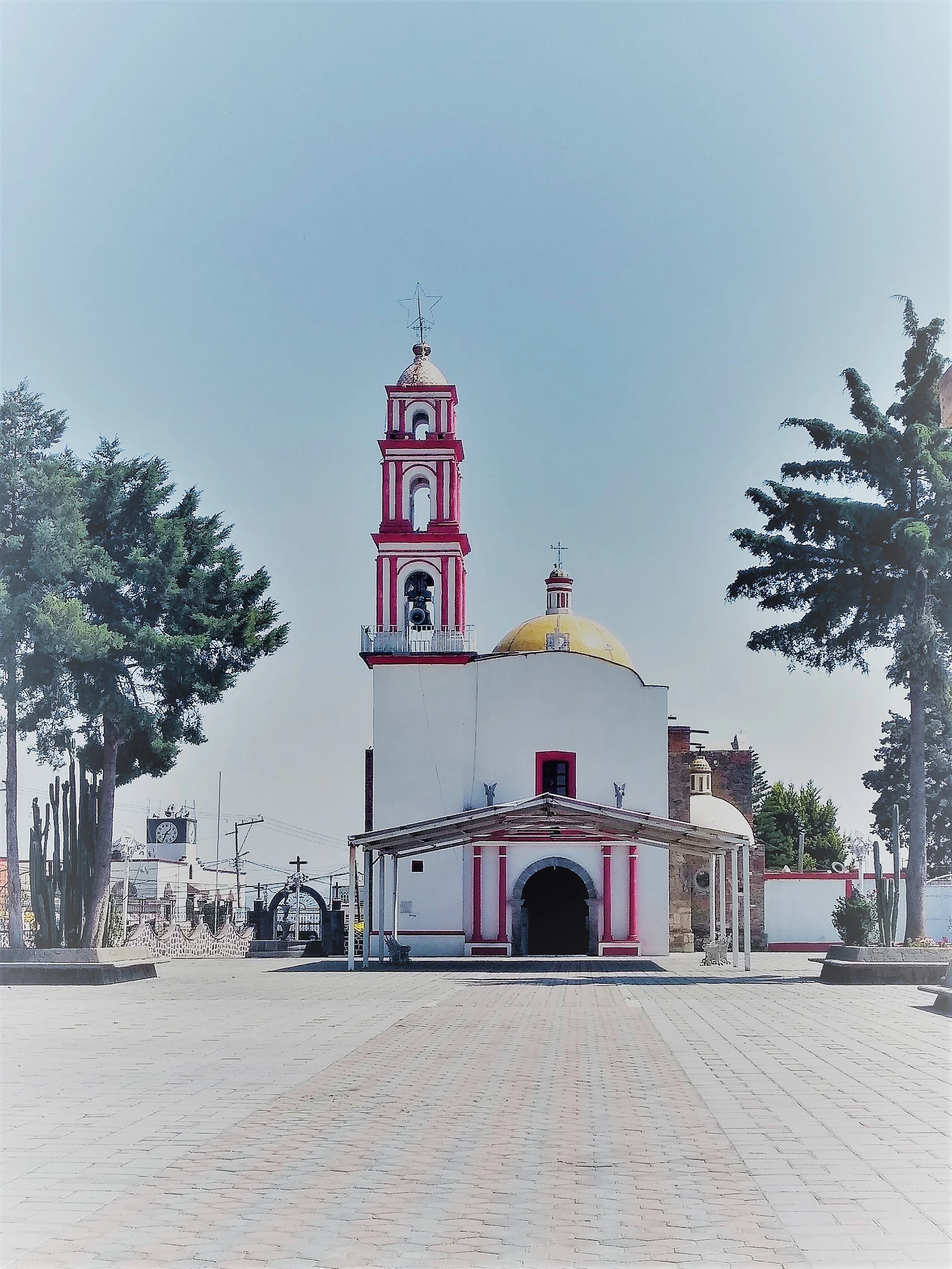
The church of Santa Ana, listed as a historic monument, has a fountain in its atrium and is the centre of the town. The patron's feast, Santa Ana, is 26 July, moved to the following Sunday when it falls on a weekday. At carnival two or three comparsas dance on Sunday, Monday and Tuesday, and on Tuesday at 18:00 the closing is held in front of the auditorium.
How to get to Santa Ana Nopalucan
Drive from San Martín Texmelucan: 15 min, 15 km
Santa Ana Nopalucan is in south-western Tlaxcala, about 32 km from Puebla city (about 35 minutes by car) and about 17 km from Huejotzingo, the nearest Pueblo Mágico (about 20 minutes). From Tlaxcala city you go through Natívitas and the lagunillas area to the square by the church of Santa Ana. The usual starting points are the Tlaxcala bus terminal or CAPU in Puebla; there are no published schedules for a direct route. Ride-hailing apps such as Uber list trips from the town to Santa Ana Chiautempan, about 22 km and 30 minutes by their estimate.
Directions to Santa Ana Nopalucan on Google Maps
Distances are in a straight line; the road is usually longer.
Links open a partner site. We may earn a commission if you book, at no cost to you.
From the nearest cities to Santa Ana Nopalucan
- San Martín Texmelucan · 15 km by road, 15 min
- Chiautempan · 23 km by road, 25 min
- Puebla · 39 km by road, 45 min
Drive times by road from OpenStreetMap, without traffic or stops. Times marked ~ are estimated from the straight-line distance.
Map of Santa Ana Nopalucan
Neighbourhoods and villages of Santa Ana Nopalucan
Part of Santa Ana Nopalucan or just outside it, closest first.
-
Santa Inés Tecuexcomac · Town · 1 km from the centre
Ixtacuixtla locality of 3,079 people, with the church of Santa Inés on the Tlaxcala-San Martín road and a farming economy. -
Santa Justina Ecatepec · Town · 2 km from the centre
Second-largest locality in Ixtacuixtla (5,122 people in 2020), on highway 117 between Tlaxcala and San Martín Texmelucan. -
San Jorge Tezoquipan · Town · 3 km from the centre
Second-largest locality in Panotla, 4,881 people in 2020, with a church of San Jorge and a Nahuatl name meaning "on the rocky mud". -
San Vicente Xiloxochitla · Town · 3 km from the centre
Natívitas community known as the cradle of the taco de canasta, with its fair on the first Sunday of December. -
La Trinidad Tenexyecac · Village · 4 km from the centre
Pottery village beside the Puebla-Tlaxcala motorway, known for mole cazuelas up to 1.40 m across. -
San Antonio Tecóac · Village · 4 km from the centre
Locality of 1,052 people in Ixtacuixtla; its Nahuatl name means "in the stone serpent" and its patron is St Anthony of Padua. -
San Antonio Tizostoc · Village · 4 km from the centre
Village at 2,252 m in Ixtacuixtla, with a church of St Anthony of Padua near the Tlaxcala–San Martín Texmelucan highway.

Day trips and tours from Santa Ana Nopalucan
The closest Pueblos Mágicos and places to visit, with the drive from Santa Ana Nopalucan and tours that leave from it.


Times marked ~ are estimated from the distance. Links open a partner site. We may earn a commission if you book, at no cost to you.
Before you go: getting to and around Santa Ana Nopalucan
- The nearest airport is Puebla (PBC).
- The best months to go are January, February, March, and November.
- 3 of the places on this page are more than 3 km from the centre: take a taxi, a ride-hailing app or a local bus.
- For day trips a rental car gives the most freedom; the tours above leave from Santa Ana Nopalucan.
Before you go to Santa Ana Nopalucan: hours, prices and tips
- Best season
- Feast of Santa Ana on 26 July (moved to the following Sunday if on a weekday); carnival closing on Tuesday at 18:00. EcuRed · checked Oct 2026
Hours and prices change, especially around holidays. Each fact links to where we checked it.
Visiting Santa Ana Nopalucan: what to see and do
The church of Santa Ana, a historic monument, with the fountain in its atrium.
The patron feast on 26 July.
The carnival, closing on Tuesday in front of the auditorium.
The nearby Cacaxtla and Xochitécatl sites, toward which the old road ran.
The ditches and the Rojano river, source of the reed and the salt.
Plan your trip
Places to stay in Santa Ana Nopalucan
Compare hotels, posadas, and rentals in and around Santa Ana Nopalucan.
Tours & activities
Day trips around Huejotzingo sometimes stop in Santa Ana Nopalucan; a tour is the easy way to see it without a car.
Rental cars
Pick up a car at PBC (Puebla): about 7 min by road to Huejotzingo, then 17 km more to Santa Ana Nopalucan, on your own schedule.
Flights
The nearest airport with scheduled flights is Puebla (PBC), about 7 min by road from Huejotzingo, the base for Santa Ana Nopalucan.
Mobile data
Signal can drop away from Huejotzingo: download a map of the way to Santa Ana Nopalucan before you set out, or carry an eSIM with data.
Links open a partner site. We may earn a commission if you book, at no cost to you.
When to go to Santa Ana Nopalucan mild
Santa Ana Nopalucan shares the climate of Huejotzingo, 17 km away. The best months to visit are January, February, March, and November.
See the month-by-month climate of Huejotzingo
Weather in Santa Ana Nopalucan now and the next 7 days
Live forecast from Open-Meteo. Chance of rain is the day's highest.
The closest Pueblo Mágico: Huejotzingo

Huejotzingo is the Pueblo Mágico closest to Santa Ana Nopalucan, with places to stay, food, and more to see.
Also close to
Near Santa Ana Nopalucan


Drive times by road from OpenStreetMap, without traffic. Times marked ~ are estimated from the straight-line distance.
Location from OpenStreetMap. Written by Puebloteca.