A region of Ciudad de México Estado de México Morelos Puebla Tlaxcala
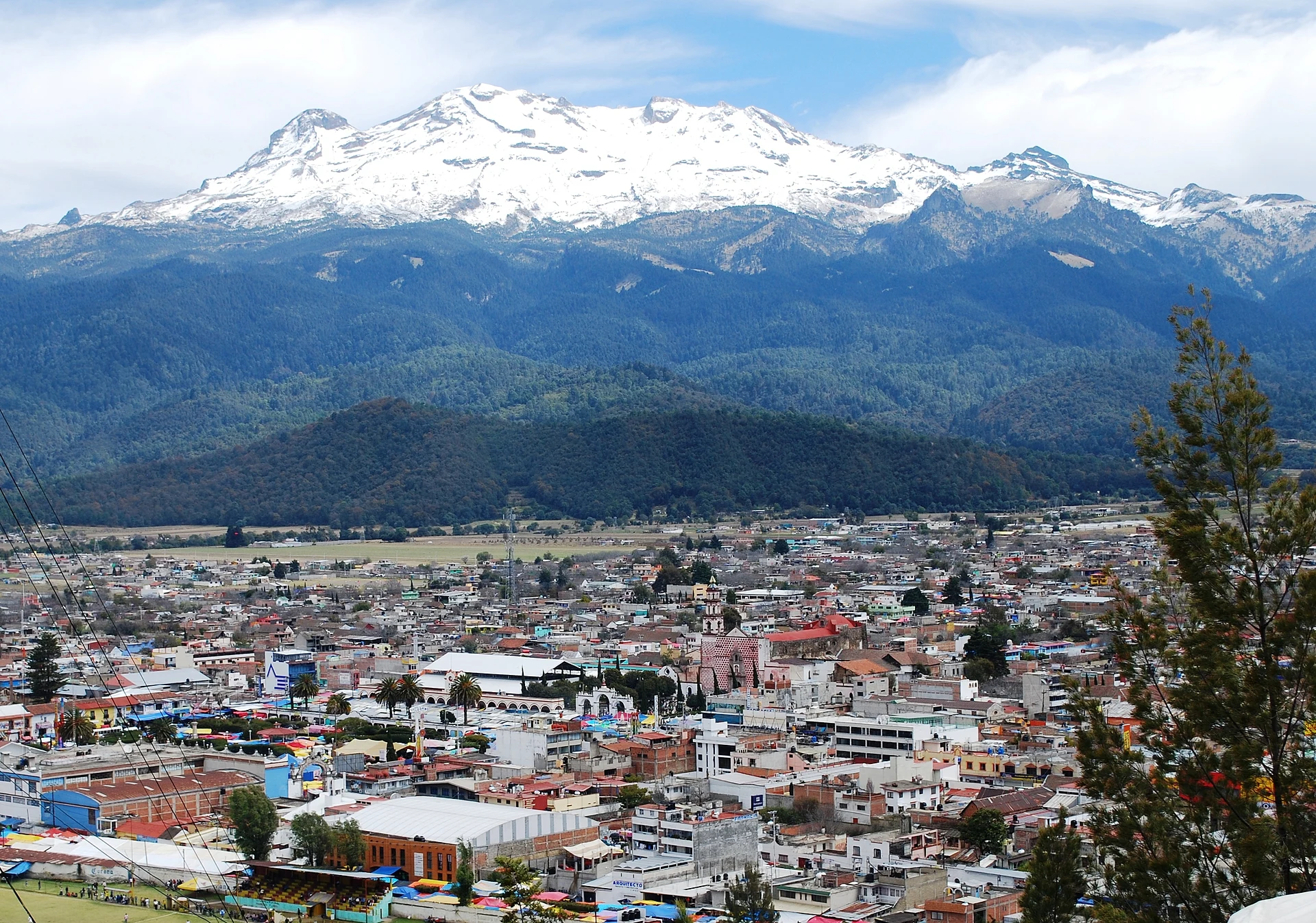
The towns and high country around Popocatépetl and Iztaccíhuatl, the snow-capped volcanoes between the valleys of Mexico and Puebla. Paso de Cortés, the saddle between them, is the way into the Izta-Popo national park; below it lie Amecameca on the Estado de México side and Huejotzingo, San Nicolás de los Ranchos and Atlixco on the Puebla side, with 16th-century convents on the slopes all around.
2 Pueblos Mágicos · 102 places to visit
Pueblos Mágicos in Volcano Route


Map
Places to visit in Volcano Route 102
102 places with their own page, grouped by kind.
Villages · 61 Towns · 27 Landmarks and museums · 6 Archaeological sites · 3 Mountains · 2 Cities · 1 Nature reserves · 1 Waterfalls · 1
Villages
-
Amilcingo · Village · Morelos
An amaranth-growing village of Temoac at 1,526 m below Popocatépetl: ahuehuete trees, the Señor de la Columna fiesta and community radio Amiltzinko. -
Analco de Ponciano Arriaga · Village · Puebla
Santa Cruz Analco, "across the water": a vegetable- and flower-growing village of San Salvador el Verde, at 2,380 m below Iztaccíhuatl. -
Atzitzihuacán · Village · Puebla
Village on the northern edge of Puebla's Mixteca by the Morelos line near Atlixco, with a 16th-century church of Santiago and a fiesta on 25 July. -
Cacaloxúchitl · Village · Puebla
"Peanut flower" in Nahuatl: a Huaquechula village at 1,627 m in the Atlixco valley, among farm fields and rivers running down from the Sierra Nevada. -
Cháhuac · Village · Puebla
Hamlet of Domingo Arenas, 5 km from Huejotzingo, on land once held by Huexotzinco's nobility and later by the Cháhuac hacienda. -
Guadalupe Zaragoza · Village · Puebla
Village in the municipality of Tlahuapan on the forested slopes of the Sierra Nevada by the State of Mexico line, honouring Ignacio Zaragoza. -
Huazulco · Village · Morelos
Morelos's 'amaranth capital' in Temoac, at 1,551 m: alegrías and sugar skulls, with the Santa Catarina fiesta on 25 November. 4,439 residents. -
Huecahuasco · Village · Morelos
Village in Ocuituco at about 2,080 m on the slopes of Popocatépetl; it existed in the 16th century and keeps St Mark's day on 25 April. -
Huejotengo · Village · Morelos
Ocuituco village at 2,164 m on the Popocatépetl slope, where women rebuilt their homes after the 2017 quake and now process avocado. -
Huepalcalco · Village · Morelos
San Miguel Huepalcalco: an Ocuituco village at 2,283 m on the Popocatépetl slope, "at the houses of planks" in Nahuatl. -
Iztapalapa de Cuitláhuac · Village · Ciudad de México
Eight-barrio original village north of Cerro de la Estrella; the San Lucas church and the Holy Week Passion play are what visitors come for. -
Jesús Tepactepec · Village · Tlaxcala
Village in Natívitas municipality, almost joined to the seat, with the sanctuary of Padre Jesús de los Tres Caminos and its March festival. -
Jumiltepec · Village · Morelos
Ocuituco village on the slopes of Popocatépetl, with a parish dating to 1551, a hilltop chapel 2 km up and a Candelaria fiesta on 2 February. -
La Magdalena Yancuitlalpan · Village · Puebla
Village of Tochimilco on the slopes of Popocatépetl, "on the new land", about 17 km from the Pueblo Mágico of Atlixco. -
Los Reyes Tlanechicolpan · Village · Puebla
Village of San Jerónimo Tecuanipan 5 km from Cholula, dedicated to the Three Kings; its Nahuatl name means "meeting place". -
Metepec · Village · Morelos
Metepec in Morelos, a village in Ocuituco municipality at 2,057 m on the slopes of Popocatépetl; not the Metepec in the State of Mexico. -
Natívitas · Village · Tlaxcala
Southern Tlaxcala seat once called "España Chiquita": a baroque parish, ruined Franciscan convent walls, and Cacaxtla just 3 km away. -
Ocoxaltepec · Village · Morelos
Village of about 1,500 people at 2,374 m on the slopes of the Popocatepetl region, in Ocuituco, with a cool, rainy mountain climate. -
Pueblo de Iztacalco · Village · Ciudad de México
A former lake-island town in east Mexico City: Franciscan San Matías church, a market and barrio chapels, a short walk from Metro Iztacalco. -
San Andrés Cuamilpa · Village · Tlaxcala
Tetlatlahuca village whose Nahuatl name means "in the wooded milpa"; church of Saint Andrew the Apostle. -
San Antonio Alpanocan · Village · Puebla
Indigenous Tochimilco community on the slopes of Popocatépetl, surrounded by Morelos; the 2017 earthquake brought down 90% of its buildings. -
San Baltazar Atlimeyaya · Village · Puebla
"Where water springs": a Tianguismanalco village at the foot of Popocatépetl, 10 km from Atlixco, in a district of forest, streams and trout. -
San Bartolomé Tenango · Village · Tlaxcala
Village in Tetlatlahuca with a 19th-century church of San Bartolomé, its tower topped by a tiled dome; fiesta on 24 August. -
San Bernabé Capula · Village · Tlaxcala
Natívitas village, "place where capulines abound", with a chapel of San Bernabé and an auxiliary president chosen by custom. -
San Buenaventura Nealtican · Village · Puebla
Seat of Nealtican, "place where I bathe", below Popocatépetl, beside a lava field with quarries and a parish church finished in 1739. -
San Buenaventura Tecaltzingo · Village · Puebla
An auxiliary borough of San Martín Texmelucan, at 2,320 m in the irrigated Atoyac valley; its Nahuatl name means 'in the little stone house'. -
San Cristóbal Nexquipayac · Village · Puebla
A hamlet of 25 people in the Tlahuapan forests, at 2,481 metres on the slopes of the Sierra Nevada near the State of Mexico line. -
San Cristóbal Tepatlaxco · Village · Puebla
Texmelucan village on highway 190 below Cerro Totolqueme, which lends its name to the pre-Hispanic mounds of Tepatlaxco. -
San Diego Huehuecalco · Village · Estado de México
Village south of Amecameca at 2,511 m, with a chapel to San Diego and a 13 to 16 November fiesta of rodeo and the dance of the Moors. -
San Felipe Teotlalcingo · Village · Puebla
"Little valley of the gods" at the foot of the Sierra Nevada, beside the Izta-Popo park, with a 17th-century parish and brickworks. -
San Francisco Huilango · Village · Puebla
Village of Tochimilco on the slopes of Popocatépetl, "where logs are dragged", about 18 km from Atlixco. -
San Francisco Zentlalpan · Village · Estado de México
Village 3 km north of Amecameca, "on the land of corn cobs"; a chapel to San Francisco de Asís and a 4 October fiesta with brass bands. -
San Gabriel Popocatla · Village · Tlaxcala
Ixtacuixtla village in western Tlaxcala, known for papier-mâché workshops that build catrinas up to 4 m tall, alebrijes and piñatas. -
San Gregorio Atzompa · Village · Puebla
Seat of its own municipality 6 km from Cholula, with a 16th-century parish to Saint Gregory, pottery and chiles en nogada with local walnuts. -
San Jerónimo Coyula · Village · Puebla
"Where rattles abound": a village of 7,750 people 9 km from Atlixco, in the valley of flowers and avocados below the volcanoes. -
San Jerónimo Tecuanipan · Village · Puebla
"Where fierce animals live": a seat of 2,545 people 11 km from Cholula, with a 16th-century church and carved metates. -
San Juan Amecac · Village · Puebla
Nahua village of Atzitzihuacán whose name means "on the thread of water", among Popocatépetl ravines near Atlixco and the Morelos border. -
San Juan Tuxco · Village · Puebla
Village of San Martín Texmelucan at the foot of the Sierra Nevada, "among the rabbits", with a parish church of San Juan and a chapel of the Sacrament. -
San Lorenzo Chiautzingo · Village · Puebla
Seat of Chiautzingo, "in the little marsh", on the foothills of the Sierra Nevada near Huejotzingo, with carnival in its barrios. -
San Lucas el Grande · Village · Puebla
The largest town in San Salvador el Verde, at 2,317 m below Iztaccíhuatl, among tejocote orchards, flower fields and black-stone workshops. -
San Luis Coyotzingo · Village · Puebla
Village in Huejotzingo with a pre-Hispanic mound dedicated to Camaxtli and an Indigenous wheat mill from 1559; a chacmool turned up here in 1973. -
San Mateo Ayecac · Village · Tlaxcala
Locality of Tepetitla on the Atoyac river, with a 19th-century church of San Mateo and a fiesta on 21 September. -
San Mateo Ozolco · Village · Puebla
"On the old road": a Calpan village at 2,674 m, stretched along a ridge between wooded ravines coming down from the Sierra Nevada. -
San Matías Cuijingo · Village · Estado de México
A Juchitepec delegation at 2,500 m with a view of Popocatépetl, legends of an eagle and San Matías, and feasts in May and December. -
San Miguel Papaxtla · Village · Puebla
Village at the foot of Cerro Tecajete, in San Jerónimo Tecuanipan, whose residents own the hill and quarry its tezontle. -
San Miguel Xochitecatitla · Village · Tlaxcala
Village of 2,199 people at the foot of the Xochitécatl archaeological zone, with a parish church to Saint Michael the Archangel. -
San Pedro Benito Juárez · Village · Puebla
The inhabited village closest to Popocatépetl's crater, about 11 km away, on the volcano's slopes in the municipality of Atlixco. -
San Salvador el Verde · Village · Puebla
Farming town in western Puebla, the old Xopalican, "green place", in a municipality that climbs to the summit of Iztaccíhuatl. -
San Vicente Chimalhuacán · Village · Estado de México
Village in Ozumba with a 16th-century Dominican convent and the parish that holds Sor Juana Inés de la Cruz's baptism record. -
Santa Ana Portales · Village · Tlaxcala
A locality of 968 people in Tetlatlahuca at 2,188 m, with the chapel of Santa Ana and San Joaquín, about 20 km from Huejotzingo. -
Santa Ana Xalmimilulco · Village · Puebla
Huejotzingo village right on the México–Puebla highway at the Tlaxcala line, with Popocatépetl and Iztaccíhuatl to the west. -
Santa Cruz Moxolahuac · Village · Puebla
Ejido village at the northern tip of Tlahuapan, 2,776 m up and right against Nanacamilpa, Tlaxcala; it lives on crops, livestock and some trade. -
Santa María Atexcac · Village · Puebla
Village of Huejotzingo at 2,400 m on the eastern slope of Iztaccíhuatl, "in the water that springs from the rock", with upper and lower quarters. -
Santa María Moyotzingo · Village · Puebla
Large town south of Texmelucan with a Preclassic pyramid base, the tepematzin, that looks like a little hill in the middle of town. -
Santa María Texmelucan · Village · Puebla
Village of Tlahuapan at the foot of Iztaccíhuatl, "place of little oaks", with a Holy Week procession that lasts all night. -
Santiago Coltzingo · Village · Puebla
"In the little bends": an auxiliary town of Tlahuapan at 2,460 m on the wooded slopes of the Sierra Nevada, land of trout and pulque. -
Santiago Tepopula · Village · Estado de México
Farming village 2 km south of Tenango del Aire on the Sierra Nevada foothills; Santiago feast from 24 to 27 July. -
Santiago Xalitzintla · Village · Puebla
The closest inhabited village to Popocatépetl's crater, 12 km away, whose people revere the volcano as Don Goyo. -
Temoac · Village · Morelos
Seat of Morelos's easternmost municipality, 28 km from Cuautla: a 16th-century church, cuexcomate granaries and the Señor de la Columna feast. -
Tianguismanalco · Village · Puebla
Village at the foot of Popocatépetl, "at the levelled market", beside the Nealtican malpaís, a lava field covered in pine-oak forest. -
Tlaltenango · Village · Puebla
Small municipal seat in metropolitan Puebla beside Huejotzingo, founded in 1527, with a parish church of San Pedro Apóstol and a brick-and-tile tradition.
























Towns
-
Amecameca de Juárez · Town · Estado de México
A Pueblo con Encanto at the foot of Iztaccíhuatl and Popocatépetl: the Sacromonte shrine, a Dominican parish, a big market and the road to Paso de Cortés. -
Atlautla de Victoria · Town · Estado de México
A farming town on the lower slopes of Popocatépetl, with a 16th-century parish of San Miguel and a 29 September feast where the archangel beats Lucifer. -
Ayapango de Gabriel Ramos Millán · Town · Estado de México
A Pueblo con Encanto below Iztaccíhuatl: named "French-style" adobe houses, the Santiago parish, the El Calvario ruins and the cheeses of nearby Poxtla. -
Juchitepec de Mariano Riva Palacio · Town · Estado de México
The "hill of flowers", on high farmland between Chalco and Morelos: the Santo Domingo parish, the Señor de las Agonías feast in April and tecuí to toast with. -
Ozumba · Town · Estado de México
A Pueblo con Encanto below Popocatépetl: Tuesday and Friday market, a Franciscan church with 16th-century murals, and the font where Sor Juana was baptised. -
San Damián Texóloc · Town · Tlaxcala
Municipal seat of just over 10 km², of pre-Hispanic origin and a milk-and-farming economy; parish of San Damián. -
San Jerónimo Zacualpan · Town · Tlaxcala
Southern Tlaxcala town with a clock-tower church, tule weaving, carnival charros and a San Jerónimo fiesta on 30 September. -
San Jorge Tezoquipan · Town · Tlaxcala
Second-largest locality in Panotla, 4,881 people in 2020, with a church of San Jorge and a Nahuatl name meaning "on the rocky mud". -
San Juan Huactzinco · Town · Tlaxcala
Bread-baking town in southern Tlaxcala with a Franciscan church from 1670, carnival costumes and a San Juan Apóstol fiesta on 27 December. -
San Lorenzo Axocomanitla · Town · Tlaxcala
One of Mexico's smallest municipalities: a 17th-century church, San Lorenzo's fiesta on 10 August and fibre basketry. -
San Miguel Xoxtla · Town · Puebla
Small municipality on the northern edge of the Puebla metro area by Tlaxcala, "abundance of flowers", split from Tlaltenango in 1940. -
San Rafael · Town · Estado de México
A paper-mill town in Tlalmanalco at the foot of Iztaccíhuatl, with a Porfirian casino, French-style houses and forest waterfalls a few km away. -
San Rafael Tlanalapan · Town · Puebla
Town in San Martín Texmelucan, "land across the river", home in mid-August to the National Chile Poblano Fair. -
San Vicente Xiloxochitla · Town · Tlaxcala
Natívitas community known as the cradle of the taco de canasta, with its fair on the first Sunday of December. -
Santa Ana Nopalucan · Town · Tlaxcala
Municipal seat in south-western Tlaxcala, a former producer of reed and salt, with the church of Santa Ana and a feast on 26 July. -
Santa Apolonia Teacalco · Town · Tlaxcala
Basket-making municipality in the Natívitas valley: huejote and pirul baskets, the church of Santa Apolonia and a fiesta on 9 February. -
Santa Justina Ecatepec · Town · Tlaxcala
Second-largest locality in Ixtacuixtla (5,122 people in 2020), on highway 117 between Tlaxcala and San Martín Texmelucan. -
Santa María Zacatepec · Town · Puebla
Town in Juan C. Bonilla beside Puebla's airport and federal highway 190, where a 130 m sinkhole opened in 2021. -
Santa Rita Tlahuapan · Town · Puebla
Seat of Tlahuapan, "land of oaks", by the Puente del Emperador on the old royal road to Mexico City; Puebla's first vineyards began here. -
Santiago Michac · Town · Tlaxcala
The most populous locality in Natívitas: church of Santiago Apóstol, a fiesta on 23-26 July and a short hop from Cacaxtla. -
Santo Tomás la Concordia · Town · Tlaxcala
Natívitas town founded after a flood, with Saint Thomas and Saint Sebastian as patrons and a moros y cristianos dance. -
Tenango del Aire · Town · Estado de México
Small seat below the volcanoes, with a 16th-century parish, a Divine Mercy shrine and the Casa de Madera museum. -
Tepetitla de Lardizábal · Town · Tlaxcala
A seat beside San Martín Texmelucan, with the church of San Mateo (fiesta 21 September), reed work and fireworks. -
Tetlatlahuca · Town · Tlaxcala
A municipal seat with the parish of Santa Isabel (fiesta 19 November), tule crafts and an ancient settlement on the Cerro de La Cruz. -
Tlalmanalco de Velázquez · Town · Estado de México
A Franciscan-founded town below Iztaccíhuatl, with a 16th-century open chapel carved by Indigenous craftsmen and a small archaeology museum. -
Villa Alta · Town · Tlaxcala
Locality in Tepetitla de Lardizábal with the former San Pedro Rojano hacienda and an April fair for the Señor de la Era. -
Villa Mariano Matamoros · Town · Tlaxcala
Seat of Ixtacuixtla, with the Franciscan ex-convent of San Felipe (1554-1585) and the tile-covered Calvario church and staircase.


Landmarks and museums
-
Convento de San Juan Bautista (Tetela del Volcán) · Landmark · Morelos
Dominican friary in Tetela del Volcán, a World Heritage site, with cloister murals of apostles and cherubs; its tower fell in the 2017 earthquake. -
Ex Convento de Santo Domingo de Guzmán · Landmark · Morelos
Dominican friary in Hueyapan, high on Popocatépetl's slopes and part of a World Heritage site; the 2017 quake brought its dome down, and restoration goes on. -
Exconvento de Santa María Magdalena · Landmark · Puebla
Baroque Dieguino convent in central San Martín Texmelucan, a national monument since 1933, with Churrigueresque altarpieces and a 1794 German organ. -
Monasterios en las faldas del Popocatépetl · Landmark · Morelos
Fourteen 16th-century friaries in Morelos and Puebla, World Heritage since 1994 (Tlaxcala joined in 2021): walled atriums, posa chapels, open chapels. -
Santuario de San Miguel del Milagro · Landmark · Tlaxcala
National Shrine of St Michael, built where tradition places the 1631 apparition to Diego Lázaro, beside Cacaxtla; pilgrims come for the water of its well. -
Templo y Exconvento de Santiago Apóstol de Ocuituco · Landmark · Morelos
The Augustinians' first convent in New Spain, begun in 1534 on Popocatépetl's slopes; World Heritage since 1994, with a lion fountain in its cloister.



Archaeological sites
-
Los Cerritos de Tepatlaxco · Archaeological site · Puebla
Nine pyramid bases on the rims of ravines on the slopes of Cerro Totolqueme, inhabited from 300 BC to 600 AD, just outside Texmelucan. -
Tlalancaleca (zona arqueológica) · Archaeological site · Puebla
Formative-period city at the foot of the Sierra Nevada, among central Mexico's largest before Teotihuacan; it outlived a Popocatépetl eruption. -
Xochitécatl · Archaeological site · Tlaxcala
A ceremonial centre begun about 800 BC on an extinct volcano's summit, with the Pyramid of the Flowers and the round Spiral Building, facing Cacaxtla.


Mountains
-
Pico Teyotl · Mountain · Puebla
A summit of about 4,600 m on the Iztaccíhuatl massif, "where stones are born", inside Izta-Popo national park, in San Salvador el Verde. -
Tecajete · Mountain · Puebla
A 2,460 m cinder cone by San Miguel Papaxtla in the Puebla valley; a short, steep path climbs to its crater and two peaks.

Cities
-
San Martín Texmelucan · City · Puebla
Market city in western Puebla, 32 km from the capital, known for its huge Tuesday clothing tianguis and the poblano chiles of Tlanalapan.

Nature reserves
-
Parque Nacional Sacromonte · Nature reserve · Estado de México
A 45-hectare sacred hill above Amecameca, a national park since 1939: the black Christ's cave shrine, a hilltop chapel and views of both volcanoes.

Waterfalls
-
Cascada de Apatlaco · Waterfall · Puebla
A roughly 50 m waterfall fed by Iztaccíhuatl's meltwater, in Apatlaco Eco Park, with cabins and camping on the road up to Paso de Cortés.

Top tours in Volcano Route


Tours, prices and ratings from Viator, checked weekly. We may earn a commission if you book.
Getting around Volcano Route
Fly into Puebla (PBC).
Cities to start from: Mexico City Puebla Cuautla Atlixco San Martín Texmelucan Chiautempan
Most of the region is reached by road: a rental car is the easiest way to see several places in a day, and buses link the larger towns.
When to visit Volcano Route
Most of Volcano Route is at its best in January, February, March, and November.
Month-by-month climate on each Pueblo Mágico's page: Atlixco, Huejotzingo