
Village Amecameca, Estado de México Municipality of Amecameca Valley of Mexico Volcano Route
Village 3 km north of Amecameca, "on the land of corn cobs"; a chapel to San Francisco de Asís and a 4 October fiesta with brass bands.
From Cuautla: 45 min by car (46 km by road) How to get there ↓
Near here
See everything nearby ↓


Plan your visit to San Francisco Zentlalpan
Where to stay near San Francisco Zentlalpan
Compare hotels, posadas and guest houses in San Francisco Zentlalpan.
Tours to San Francisco Zentlalpan
Day trips and guided outings from Tlayacapan often include San Francisco Zentlalpan; with a local guide you can get there without a car.
 Tours from Atlixco
Atlixco Volcano Views Popocatépetl Tour Forest Route
From US$108
How to get to San Francisco Zentlalpan
- From Cuautla: about 45 min by road (~46 km)
- Nearest airport: Mexico City (MEX), 1 h 33 min by car to Tlayacapan
Links open a partner site. We may earn a commission if you book, at no cost to you.
Tours from Atlixco, near San Francisco Zentlalpan
Tours, prices and ratings from Viator, checked weekly. We may earn a commission if you book.
About San Francisco Zentlalpan
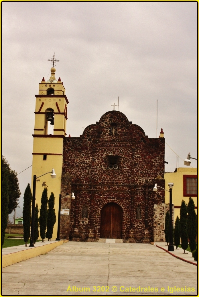
Zentlalpan sits about 3 km north of Amecameca's centre in a straight line and had 2,024 inhabitants in 2020. The name comes from centli, corn cob, tlalli, land, and pan, on top of: "on the land of corn cobs", which suits the farming landscape of the valley. San Francisco de Asís is the patron, and his chapel, with a dark stone front and a yellow-painted bell tower, is the first thing you notice on arrival.
The feast falls on 4 October. Amecameca's town hall describes this village's celebration as several bands playing, with processions and masses for the saint. It is the date to come if you want to see the village gathered; the rest of the year it is a small community with no tourist services of its own.
Zentlalpan works best as a short stop on a visit to Amecameca, where the municipality's real draws are: the Asunción parish, built in the 16th century, the Sacromonte with its shrine, the Panoaya hacienda museums, the Apatlaco waterfall and the pass between the two volcanoes. Amecameca is also where to stock up, at its Monday, Wednesday and Sunday tianguis.
How to get to San Francisco Zentlalpan
Drive from Cuautla: 45 min, 46 km
Zentlalpan lies north of Amecameca, so from the capital you cover nearly the whole trip on the 115, past Chalco. By car it is about 53 km and a little under an hour from TAPO (Rome2Rio). On the bus there are two ways: the direct service to Amecameca, or a Super Rápidos to San Marcos Huixtoco and a transfer to Volcanes at Caseta Chalco; either way allow roughly an hour and ten minutes. Once in Amecameca, the village is about 3 km from the terminal (a few blocks northwest of the zócalo) by air, close to ten minutes by taxi on my reckoning. There is no published published public route. Cuautla is about 39 km away by air.
Directions to San Francisco Zentlalpan on Google Maps
Distances are in a straight line; the road is usually longer.
Links open a partner site. We may earn a commission if you book, at no cost to you.
From the nearest cities to San Francisco Zentlalpan
- Cuautla · 46 km by road, 45 min
- Mexico City · 57 km by road, 55 min
- San Martín Texmelucan · 81 km by road, 1 h 15 min
Drive times by road from OpenStreetMap, without traffic or stops. Times marked ~ are estimated from the straight-line distance.
Before you go to San Francisco Zentlalpan: hours, prices and tips
- Hours
- Amecameca's tianguis (street market) runs on Mondays, Wednesdays and Sundays. Wikivoyage (Amecameca) · checked Oct 2026
- Best season
- Patron feast of San Francisco de Asís on 4 October, with several bands, processions and masses. Gobierno de Amecameca y Wikipedia (Municipio de Amecameca) · checked Oct 2026
Hours and prices change, especially around holidays. Each fact links to where we checked it.
Visiting San Francisco Zentlalpan: what to see and do
Look at the chapel of San Francisco de Asís, dark stone with a yellow bell tower, by the village square.
Come on 4 October for the patron feast, with bands, procession and mass.
Visit the Asunción parish on Amecameca's zócalo, built between 1554 and 1562.
Climb the Sacromonte, with the shrine of the Señor del Sacromonte and views of the volcanoes.
Head to the Apatlaco waterfall or to Paso de Cortés, between Popocatépetl and Iztaccíhuatl.
Plan your trip
Places to stay in San Francisco Zentlalpan
Compare hotels, posadas, and rentals in and around San Francisco Zentlalpan.
Tours & activities
Day trips and guided outings from Tlayacapan often include San Francisco Zentlalpan; with a local guide you can get there without a car.
Rental cars
Pick up a car at MEX (Mexico City): about 1 h 33 min by road to Tlayacapan, then 30 km more to San Francisco Zentlalpan, on your own schedule.
Flights
The nearest airport with scheduled flights is Mexico City (MEX), about 1 h 33 min by road from Tlayacapan, the base for San Francisco Zentlalpan.
Mobile data
Signal can drop away from Tlayacapan: download a map of the way to San Francisco Zentlalpan before you set out, or carry an eSIM with data.
Links open a partner site. We may earn a commission if you book, at no cost to you.
When to go to San Francisco Zentlalpan mild
San Francisco Zentlalpan shares the climate of Tlayacapan, 30 km away. The best months to visit are January, February, March, and December.
See the month-by-month climate of Tlayacapan
Weather in San Francisco Zentlalpan now and the next 7 days
Live forecast from Open-Meteo. Chance of rain is the day's highest.
The closest Pueblo Mágico: Tlayacapan

Tlayacapan is the Pueblo Mágico closest to San Francisco Zentlalpan, with places to stay, food, and more to see.
Also close to
- Tepoztlán · Morelos · 38 km away
- Huejotzingo · Puebla · 39 km away
- Atlixco · Puebla · 46 km away
- Cholula · Puebla · 51 km away
- Otumba · Estado de México · 61 km away
Closest to San Francisco Zentlalpan
-
Parque Nacional Sacromonte · Nature reserve · 2 km away
-
Amecameca de Juárez · Town · 3 km away
-
Ayapango de Gabriel Ramos Millán · Town · 3 km away
-
San Diego Huehuecalco · Village · 7 km away
-
San Rafael · Town · 7 km away
-
Tlalmanalco de Velázquez · Town · 7 km away
-
Santiago Tepopula · Village · 8 km away
-
Tenango del Aire · Town · 8 km away


Near San Francisco Zentlalpan


Drive times by road from OpenStreetMap, without traffic. Times marked ~ are estimated from the straight-line distance.
Location from OpenStreetMap. Written by Puebloteca.