
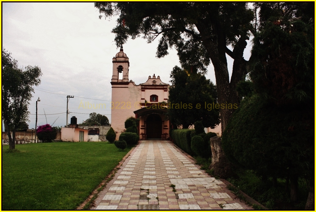
Village Cocotitlán, Estado de México Valley of Mexico
Cocotitlán's second-largest village, the "place of many maguey"; a chapel to San Andrés, a mammoth find, and an 1885 photograph in INAH's archive.
From Mexico City: 45 min by car (47 km by road) How to get there ↓
Near here
See everything nearby ↓


Plan your visit to San Andrés Metla
Where to stay near San Andrés Metla
Compare hotels, posadas and guest houses in San Andrés Metla.
Tours to San Andrés Metla
Day trips and guided outings from Tlayacapan often include San Andrés Metla; with a local guide you can get there without a car.
How to get to San Andrés Metla
- From Mexico City: about 45 min by road (~47 km)
- Nearest airport: Mexico City (MEX), 1 h 33 min by car to Tlayacapan
Links open a partner site. We may earn a commission if you book, at no cost to you.
About San Andrés Metla
San Andrés Metla counted 2,372 residents in 2020, making it Cocotitlán's second-largest locality after the seat, which lies roughly 3 km away in a straight line. The name joins metl, maguey, with tlan, abundance: "where maguey is plentiful". Saint Andrew the Apostle is the patron. A photograph from 1885 by Alfred Briquet, now in INAH's Fototeca Nacional and captioned "San Andrés Metla, a village of the municipality of Cocotitlán", shows how long the village has been on record; at the time it belonged to the district of Chalco.
A Revista Zócalo piece on the municipality reports that mammoth remains turned up in San Andrés Metla, and describes petroglyphs and pre-Hispanic stone and clay figurines on the Cerro de Cocotitlán, the neighbouring hill with the chapel of the Virgen de Guadalupe. The place of worship is the chapel of San Andrés on Calle Chapultepec, in the middle of the village. For the festival calendar look at the whole municipality: San José on 19 March, the Purísima on 8 December, and the Feria del Elote, which runs from the first Saturday of August to the first Sunday of September. Cocotitlán's Segadores, Serranos and Pastoras dances are performed at patron-saint feasts, and the Marotas at Todos Santos.
How to get to San Andrés Metla
Drive from Mexico City: 45 min, 47 km
Volcanes coaches leave TAPO for Cocotitlán (stop: Cedral) about every half hour and take close to 55 minutes (Rome2Rio data; check with the company). A Super Rápidos to San Marcos Huixtoco followed by a Volcanes from Caseta Chalco also works. Driving, it is some 36 km from TAPO, 37 minutes without traffic: motorway toward Puebla, exit for Chalco, then federal 115 (México–Cuautla), which goes on to Amecameca.
Cocotitlán is 3 km by air from Metla, a short taxi hop or about 10 minutes' drive (my estimate). There is no published direct link with Tlayacapan, in Morelos, though the air distance is around 33 km.
Directions to San Andrés Metla on Google Maps
Distances are in a straight line; the road is usually longer.
Links open a partner site. We may earn a commission if you book, at no cost to you.
From the nearest cities to San Andrés Metla
- Mexico City · 47 km by road, 45 min
- Cuautla · 57 km by road, 55 min
- San Martín Texmelucan · 71 km by road, 1 h 5 min
Drive times by road from OpenStreetMap, without traffic or stops. Times marked ~ are estimated from the straight-line distance.
Before you go to San Andrés Metla: hours, prices and tips
- Best season
- The Feria del Elote runs in Cocotitlán from the first Saturday of August to the first Sunday of September; San José is on 19 March and the Purísima on 8 December (municipal feasts, not Metla-specific). Wikipedia (Municipio de Cocotitlán) · checked Oct 2026
Hours and prices change, especially around holidays. Each fact links to where we checked it.
Visiting San Andrés Metla: what to see and do
Visit the chapel of San Andrés on Calle Chapultepec, in the middle of the village.
Climb the Cerro de Cocotitlán, with its chapel of the Virgen de Guadalupe and the petroglyphs the Zócalo report describes (ask locally about access).
Head into Cocotitlán for the parish of the Purísima Concepción, finished in 1700, with its Baroque altarpieces.
Come in August or September for the municipality's Feria del Elote.
Plan your trip
Places to stay in San Andrés Metla
Compare hotels, posadas, and rentals in and around San Andrés Metla.
Tours & activities
Day trips and guided outings from Tlayacapan often include San Andrés Metla; with a local guide you can get there without a car.
Rental cars
Pick up a car at MEX (Mexico City): about 1 h 33 min by road to Tlayacapan, then 33 km more to San Andrés Metla, on your own schedule.
Flights
The nearest airport with scheduled flights is Mexico City (MEX), about 1 h 33 min by road from Tlayacapan, the base for San Andrés Metla.
Mobile data
Signal can drop away from Tlayacapan: download a map of the way to San Andrés Metla before you set out, or carry an eSIM with data.
Links open a partner site. We may earn a commission if you book, at no cost to you.
When to go to San Andrés Metla mild
San Andrés Metla shares the climate of Tlayacapan, 33 km away. The best months to visit are January, February, March, and December.
See the month-by-month climate of Tlayacapan
Weather in San Andrés Metla now and the next 7 days
Live forecast from Open-Meteo. Chance of rain is the day's highest.
The closest Pueblo Mágico: Tlayacapan

Tlayacapan is the Pueblo Mágico closest to San Andrés Metla, with places to stay, food, and more to see.
Also close to
- Tepoztlán · Morelos · 37 km away
- Huejotzingo · Puebla · 46 km away
- Teotihuacán · Estado de México · 53 km away
- Otumba · Estado de México · 54 km away
- Atlixco · Puebla · 55 km away
Closest to San Andrés Metla
-
Cocotitlán · Town · 3 km away
-
Tlalmanalco de Velázquez · Town · 4 km away
-
San Gregorio Cuautzingo · Village · 5 km away
-
San Pablo Atlazalpan · Town · 7 km away
-
Tenango del Aire · Town · 7 km away
-
Chalco de Díaz Covarrubias · City · 8 km away
-
Santiago Tepopula · Village · 8 km away
-
San Rafael · Town · 9 km away


Near San Andrés Metla


Drive times by road from OpenStreetMap, without traffic. Times marked ~ are estimated from the straight-line distance.
Location from OpenStreetMap. Written by Puebloteca.