Town Cocotitlán, Estado de México Valley of Mexico
A Chalco-valley town with a church finished in 1700, Baroque altarpieces, a corn fair every August and the Marotas dancers on All Saints' night.
From Mexico City: 45 min by car (44 km by road) How to get there ↓
Near here
See everything nearby ↓


Plan your visit to Cocotitlán
Where to stay near Cocotitlán
Compare hotels, posadas and guest houses in Cocotitlán.
Tours to Cocotitlán
Day trips around Tlayacapan sometimes stop in Cocotitlán; a tour is the easy way to see it without a car.
 Tours from Mexico City
Teotihuacan pyramids morning or afternoon without tourist traps
★ 4.9 (10,269) · From US$59
How to get to Cocotitlán
- From Mexico City: about 45 min by road (~44 km)
- Nearest airport: Mexico City (MEX), 1 h 33 min by car to Tlayacapan
Links open a partner site. We may earn a commission if you book, at no cost to you.
Tours from Mexico City, near Cocotitlán


Tours, prices and ratings from Viator, checked weekly. We may earn a commission if you book.
About Cocotitlán
Cocotitlán lies on the southern edge of the Chalco valley, on the México–Cuautla highway, about 40 km from Mexico City at roughly 2,310 m. It is the seat of a small municipality almost wrapped by Chalco, Tlalmanalco and Temamatla, and had 10,290 residents in 2020. The Nahuatl name, from cocotli, turtle dove, means "place of doves".
People have lived here a long time: archaeologist Jaime Noyola, quoted by the federal municipal encyclopedia, places large villages at Cocotitlán and neighbouring Metla a century or two before the Common Era, and platforms, pottery and a tomb have been found. In colonial times the town, then San José Cocotitlán, was a mission station of the Franciscans at Tlalmanalco. It became a municipality on 13 May 1868, together with San Andrés Metla, whose authorities keep a codex dated 1674. The Revolution swept back and forth through it: followers of Félix Díaz held it in 1912, by the end of that year General Everardo González's Zapatistas had made it their headquarters, from which they attacked Chalco in September 1913, and the town changed hands again in 1915 and 1916.
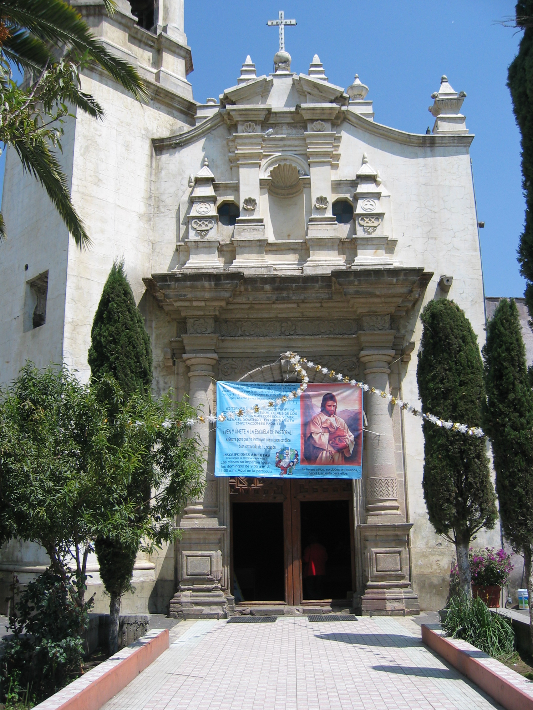
The visit centres on the parish church of the Purísima Concepción. A stone plaque beside its arches records that it was finished on 9 April 1700. It is built as a Latin cross, and its treasure is its Baroque altarpieces: the main one is dedicated to Saint Joseph, the town's patron, flanked by a Passion altarpiece and one of Nuestro Padre Jesús, while paintings of the twelve apostles line the nave. The 2017 earthquake damaged the tower, and a full restoration took nearly eight years. The same encyclopedia mentions a chapitel, a small late 16th-century oratory, and a chapel set among boulders carved with petroglyphs.
The days to come are 19 March, Saint Joseph's day, and 8 December, with the Segadores, Serranos and Pastoras dances and the Aztec dance locals call "Los Apaches". August brings the corn fair, and on the night of 1 November the Marotas dance through the streets around bonfires lit in front of each house. Rainy-season cooking means chileatole, a corn and epazote drink, and in October and November shacualote, squash candied with piloncillo.
How to get to Cocotitlán
Drive from Mexico City: 45 min, 44 km
This is the easiest town in the area to reach: about 39 km from the TAPO terminal, around 40 minutes without traffic. Calzada Ignacio Zaragoza leads to the México–Puebla toll road (150D); at the Chalco exit drop onto Federal Highway 115 (México–Cuautla), and Cocotitlán is a few kilometres south, beside the highway. State road 900 to Juchitepec and Tepetlixpa starts here.
By public transport, Volcanes buses leave the TAPO (Metro San Lázaro) along the Cuautla road about every 30 minutes, taking about 55 minutes; alternatively ride Super Rápidos to San Marcos Huixtoco, by the Chalco toll booth, and change to a Volcanes bus for the last 10 minutes or so. Tlayacapan, the nearest of our pueblos, is about 49 km away via Juchitepec and Highway 113, roughly an hour.
Directions to Cocotitlán on Google Maps
Distances are in a straight line; the road is usually longer.
Links open a partner site. We may earn a commission if you book, at no cost to you.
From the nearest cities to Cocotitlán
- Mexico City · 44 km by road, 45 min
- Cuautla · 61 km by road, 1 h
- San Martín Texmelucan · 68 km by road, 1 h 5 min
Drive times by road from OpenStreetMap, without traffic or stops. Times marked ~ are estimated from the straight-line distance.
Before you go to Cocotitlán: hours, prices and tips
- Best season
- The main feasts are 19 March (Saint Joseph, the patron), 8 December (the Immaculate Conception) and 12 December (Our Lady of Guadalupe). The corn fair runs from the first Saturday of August to the first Sunday of September. Wikipedia · checked Oct 2026
Hours and prices change, especially around holidays. Each fact links to where we checked it.
Visiting Cocotitlán: what to see and do
The parish church of the Purísima Concepción, finished in 1700, with the plaque recording it beside the arches.
The Baroque altarpiece of Saint Joseph and the side altarpieces of the Passion and Nuestro Padre Jesús.
The paintings of the twelve apostles in the nave.
The chapitel, a small late 16th-century oratory.
The chapel among boulders carved with petroglyphs.
The corn fair, from early August to early September.
The Marotas dance on the night of 1 November.
Plan your trip
Places to stay in Cocotitlán
Compare hotels, posadas, and rentals in and around Cocotitlán.
Tours & activities
Day trips around Tlayacapan sometimes stop in Cocotitlán; a tour is the easy way to see it without a car.
Rental cars
Pick up a car at MEX (Mexico City): about 1 h 33 min by road to Tlayacapan, then 33 km more to Cocotitlán, on your own schedule.
Flights
The nearest airport with scheduled flights is Mexico City (MEX), about 1 h 33 min by road from Tlayacapan, the base for Cocotitlán.
Mobile data
Signal can drop away from Tlayacapan: download a map of the way to Cocotitlán before you set out, or carry an eSIM with data.
Links open a partner site. We may earn a commission if you book, at no cost to you.
When to go to Cocotitlán mild
Cocotitlán shares the climate of Tlayacapan, 33 km away. The best months to visit are January, February, March, and December.
See the month-by-month climate of Tlayacapan
Weather in Cocotitlán now and the next 7 days
Live forecast from Open-Meteo. Chance of rain is the day's highest.
The closest Pueblo Mágico: Tlayacapan

Tlayacapan is the Pueblo Mágico closest to Cocotitlán, with places to stay, food, and more to see.
Also close to
- Tepoztlán · Morelos · 37 km away
- Huejotzingo · Puebla · 49 km away
- Teotihuacán · Estado de México · 51 km away
- Otumba · Estado de México · 53 km away
- Atlixco · Puebla · 58 km away
Closest to Cocotitlán
-
San Andrés Metla · Village · 3 km away
-
San Gregorio Cuautzingo · Village · 3 km away
-
Chalco de Díaz Covarrubias · City · 5 km away
-
San Pablo Atlazalpan · Town · 5 km away
-
Tlalmanalco de Velázquez · Town · 7 km away
-
Cerro Xico · Mountain · 8 km away
-
Tenango del Aire · Town · 8 km away
-
Ixtapaluca · City · 10 km away


Near Cocotitlán


Drive times by road from OpenStreetMap, without traffic. Times marked ~ are estimated from the straight-line distance.
Location from OpenStreetMap. Written by Puebloteca.